Saint-Hilaire-de-Briouze
Saint-Hilaire-de-Briouze | |
|---|---|
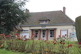
 The town hall in Saint-Hilaire-de-Briouze | |
| Coordinates: 48°42′24″N 0°19′23″W / 48.7067°N 0.3231°W | |
| Country | France |
| Region | Normandy |
| Department | Orne |
| Arrondissement | Argentan |
| Canton | Athis-Val de Rouvre |
| Intercommunality | Val d'Orne |
| Government | |
| • Mayor (2020–2026) | Christine Pommier[1] |
Area 1 | 13.63 km2 (5.26 sq mi) |
| Population (2022)[2] | 299 |
| • Density | 22/km2 (57/sq mi) |
| Time zone | UTC+01:00 (CET) |
| • Summer (DST) | UTC+02:00 (CEST) |
| INSEE/Postal code | 61402 /61220 |
| Elevation | 201–270 m (659–886 ft) (avg. 221 m or 725 ft) |
| 1 French Land Register data, which excludes lakes, ponds, glaciers > 1 km2 (0.386 sq mi or 247 acres) and river estuaries. | |
Saint-Hilaire-de-Briouze (French pronunciation: [sɛ̃t‿ilɛʁ də bʁijuz] ⓘ, literally Saint-Hilaire of Briouze) is a commune in the Orne department in north-western France.[3]
Geography
The commune is made up of the following collection of villages and hamlets, Le Valdary, Les Auges,Les Mézerets, La Huverie, La Grande Bêche and Saint-Hilaire-de-Briouze.[4]
The commune borders the area known as Suisse Normande.[5]
Saint-Hilaire-de-Briouze along with another 70 communes is part of a 20,593 hectare, Natura 2000 conservation area, called the Haute vallée de l'Orne et affluents.[6]
There are 4 watercourses that run through the commune, The river Rouvre plus 3 streams, Fief Benoit, Gué d'Arnettes, and the Vaux.
- Church of Saint-Hilaire
- war memorial of Saint-Hilaire-de-Briouze
- Chapelle of Saint-Hermeland de Montreuil-au-Houlme
See also
References
- ^ "Répertoire national des élus: les maires". data.gouv.fr, Plateforme ouverte des données publiques françaises (in French). 9 August 2021.
- ^ "Populations de référence 2022" (in French). The National Institute of Statistics and Economic Studies. 19 December 2024.
- ^ "Commune de Saint-Hilaire-de-Briouze (61402)". INSEE.
- ^ a b "Saint-Hilaire-de-Briouze · 61220, France". Saint-Hilaire-de-Briouze · 61220, France.
- ^ "Map of Suisse Normande" (PDF).
- ^ "INPN - FSD Natura 2000 - FR2500099 - Haute vallée de l'Orne et affluents - Description".


