
Pelsall Wood
| Pelsall Wood | |
|---|---|
| Area | |
 Wood Lane, Pelsall Wood, Pelsall | |
 Pelsall Wood Location within the West Midlands | |
| OS grid reference | SK016038 |
| Metropolitan borough | |
| Metropolitan county | |
| Region | |
| Country | England |
| Sovereign state | United Kingdom |
| Post town | WALSALL |
| Postcode district | WS3 |
| Dialling code | 01922 |
| Police | West Midlands |
| Fire | West Midlands |
| Ambulance | West Midlands |
| UK Parliament | |
Pelsall Wood is an area[1][2] of Pelsall in the Metropolitan Borough of Walsall in the West Midlands county of England. It is located 1 mile (1.6 km) to the northwest of Pelsall, 2 miles (3.2 km) northeast of Bloxwich, 3 miles (4.8 km) southwest of Brownhills, 4 miles (6.4 km) northeast of Walsall, 7 miles (11 km) southeast of Cannock and 7 miles (11 km) southwest of Burntwood. It is close to Pelsall North Common.[3]
History
According to a 19th century, the land around Pelsall Wood consisted of nothing more than open land and Iron Works, as well as the Wyrley and Essington Canal at Pelsall Junction passing through it.[4] In the 20th century, the land around Pelsall Wood had slightly expanded to include an inn and some properties towards the Iron Works.[5] Pelsall Wood was once the home to the "Pelsall Wood Colliery".[6][7] The colliery was opened by the Pelsall Coal & Iron Company. It was later purchased by the Walsall Wood Colliery in 1894. It continued to operate and mine coal until 1964, when the coal deposits at the site were depleted. In an entry from the Walsall Wood in history by Walsall Council,[8] it mentions:
In the late 19th century the Company took over the Pelsall Coal & Iron Company, whose engineer developed and put into use one of the first coal cutting machines in the country.
— Walsall Council, Walsall Wood in history
After closure of the colliery, the area around it was redeveloped for housing.[9] Building of the estate was undertaken by Aldridge Urban District Council.[10]
From 1735 until 2005, there was a pub called the "Free Trade Inn".[11] It was left abandoned after closure for a number of years until 2018, when it was converted into three houses.[12]
Canal
To the north and northeast, the Wyrley and Essington Canal runs passed the estate. Additionally, Pelsall Junction[13] and the Pelsall Works Bridge cross the canal.[14]
Pelsall North Common
Pelsall North Common, acts as an extension of the nearby Pelsall Common and is a large open heath land.
Some notable landmarks and points of interest around the common include:
- The Cannock Extension Canal - A partially disused canal that connected Pelsall to Cannock. It now only runs from the junction at Pelsall to the A5 Road/Watling Street at North Lanes and Norton Canes.[15]
- The Fingerpost Pub - A public house situated above the canal and off Norton Road.[16]
- Pelsall Iron Works Site - The site of the former Pelsall Iron Works, opened in 1832 by Richard Fryer from Lord Hatherton.[17] The site of the Iron Works are now part of the common.[18]
- Pelsall Junction - A junction for the Wyrley and Essington Canal and Cannock Extension Canal. The footbridge crossing the Wyrley and Essington Canal is a Grade II listed building.[19]
- Pelsall Works Bridge - The former entry to the Pelsall Iron Works, now used for public and cycle access to both Fishley Lane and the canal's footpath to the common. It is a Grade II listed building.[20]
- York's Bridge - An old Victorian-built road bridge connecting Pelsall to Norton Canes, Great Wyrley, Landywood, Little Wyrley, North Lanes and Little Bloxwich.[21] A new road bridge is currently being constructed to replace Yorks Bridge.[22]
 The Canal Extension Canal leaving Pelsall Junction
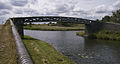 Pelsall Junction Footbridge
 Pelsall Works Bridge
 Yorks Bridge and the Fingerpost Pub (formerly the Royal Oak)
 Pelsall North Common
 The Wyrley and Essington Canal, the site of Pelsall Iron Works was across the canal


Transport
The main road through that passes the area is the A4124/Wolverhampton Road. There is also a regular bus service, operated by National Express West Midlands between Walsall, Bloxwich, Wednesfield and Wolverhampton. Additional buses operated by Walsall Community Transport link the area to Kingstanding, Brownhills, Leamore and Brownhills West.[23] The nearest railway stations are Bloxwich, Bloxwich North, Landywood and Walsall on the Chase Line. As well as Shenstone on the Cross-City Line and Wolverhampton for services on the Rugby–Birmingham–Stafford line and West Coast Main Line. The area's nearest railway stations were in both Pelsall and Brownhills on the former South Staffordshire line. This line now forms the McClean Way greenway between Walsall and Lichfield.
References
- ^ "Pelsall Wood". britishplacenames.uk. Retrieved 7 February 2025.
- ^ "pelsall wood estate". THE BNA. Retrieved 7 February 2025.
{{cite web}}: CS1 maint: url-status (link) - ^ "Pelsall North Common Local Nature Reserve and Nest Common | Walsall Council". go.walsall.gov.uk. Retrieved 13 November 2024.
- ^ "Ordnance Survey First Series, Sheet 62,". www.visionofbritain.org.uk. Vision of Britain. Retrieved 7 February 2025.
- ^ "Ordnance Survey of Great Britain New Popular Edition, Sheet 119 - Stafford". www.visionofbritain.org.uk. Vision of Britain. Retrieved 7 February 2025.
- ^ Baker (geologist.), Thomas (1848). Bakers's Practical survey of the geology, mineralogy, and historical events of the district of Dudley. p. 61.
- ^ List of the Plans of Abandoned Mines Deposited in the Home Office Under the Coal & Metalliferous Mines Regulation Acts. H.M. Stationery Office. 1897. p. 59.
- ^ "Walsall Wood in history | Walsall Council". go.walsall.gov.uk. Retrieved 7 February 2025.
- ^ Civil and Structural Engineers Review. 1956. p. 564.
- ^ Highways and Bridges and Engineering Works. Road Publications. 1952. p. 15.
- ^ "The Free Trade Inn, Wood Lane, Pelsall". Black Country History. Retrieved 7 February 2025.
{{cite web}}: CS1 maint: url-status (link) - ^ "The Free Trade Inn". pelsalltimes. Retrieved 7 February 2025.
- ^ "Pelsall Junction – Gazetteer – CanalPlanAC". CanalplanAC - Canal Route Planner. Retrieved 7 February 2025.
- ^ Shill, Ray (15 February 2013). Wyrley & Essington Canal Through Time. Amberley Publishing Limited. ISBN 978-1-4456-3243-8.
- ^ "Cannock Extension Canal | Canal maps". canalrivertrust.org.uk. Retrieved 7 February 2025.
- ^ "The Fingerpost | Pub | Pelsall, Walsall WS3 5AU, UK". Mysite. Retrieved 7 February 2025.
- ^ "Pelsall Coal and Iron Company". pelsalltimes. Retrieved 7 February 2025.
- ^ "Pelsall Ironworks, Pelsall North Common". Black Country History. Retrieved 7 February 2025.
- ^ Historic England. "WYRLEY AND ESSINGTON CANAL FOOTBRIDGE AT PELSALL JUNCTION (Grade II) (1077179)". National Heritage List for England. Retrieved 7 February 2025.
- ^ Historic England. "Pelsall Works Bridge (Grade II) (1087110)". National Heritage List for England. Retrieved 7 February 2025.
- ^ "A History of York's Bridge". pelsalltimes. Retrieved 7 February 2025.
- ^ Hardiman, Deborah (30 December 2024). "Watch: Work gathering pace on £3m canal bridge replacement near Walsall to improve road safety". www.expressandstar.com. Retrieved 7 February 2025.
- ^ "Pelsall Wood – Bus Times". bustimes.org. Retrieved 7 February 2025.