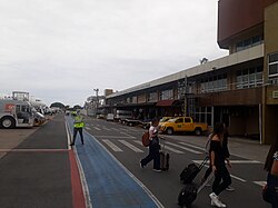
Navegantes Airport
Navegantes–Ministro Victor Konder International Airport Aeroporto Internacional de Navegantes–Ministro Victor Konder | |||||||||||
|---|---|---|---|---|---|---|---|---|---|---|---|
 | |||||||||||
 | |||||||||||
| Summary | |||||||||||
| Airport type | Public | ||||||||||
| Operator | |||||||||||
| Serves | Navegantes | ||||||||||
| Time zone | BRT (UTC−03:00) | ||||||||||
| Elevation AMSL | 5 m / 18 ft | ||||||||||
| Coordinates | 26°52′43″S 048°39′03″W / 26.87861°S 48.65083°W | ||||||||||
| Website | www | ||||||||||
| Map | |||||||||||
 | |||||||||||
| Runways | |||||||||||
| |||||||||||
| Statistics (2024) | |||||||||||
| |||||||||||
Navegantes–Ministro Victor Konder International Airport (IATA: NVT, ICAO: SBNF) is the airport serving Navegantes, Brazil, as well as Itajaí, Balneário Camboriú, and Blumenau. Since June 10, 1959, it is named after the Itajaí-born Victor Konder (1886–1941), Minister of Public Works (1926–1930), whose administration encouraged the birth of Brazilian commercial aviation.[5]
The airport is operated by CCR.
History
At the time of its foundation, Navegantes was a district of Itajaí. With its emancipation in 1961, it was necessary to adapt the airport name to its present form. This was done on December 30, 2002, by a presidential decree.[6]
Previously operated by Infraero, on April 7, 2021, CCR won a 30-year concession to operate the airport.[7]
Airlines and destinations
| Airlines | Destinations |
|---|---|
| Azul Brazilian Airlines | Belo Horizonte–Confins, Campinas Seasonal: Chapecó, Foz do Iguaçu, Recife[8] |
| Gol Linhas Aéreas | Rio de Janeiro–Galeão, São Paulo–Congonhas, São Paulo–Guarulhos Seasonal: Buenos Aires–Ezeiza |
| LATAM Brasil | São Paulo–Congonhas, São Paulo–Guarulhos Seasonal: Brasília |
Statistics

Following is the number of passenger, aircraft and cargo movements at the airport, according to Infraero (2007-2021) and CCR (2022-2024) reports:[9][10][1]
| Year | Passenger | Aircraft | Cargo (t) |
|---|---|---|---|
| 2024 | 1,996,630 |
23,114 |
|
| 2023 | 2,217,744 | 25,881 | |
| 2022a | 1,486,900 | 19,049 | |
| 2021 | 1,396,981 |
19,508 |
3,140 |
| 2020 | 921,153 |
14,060 |
2,287 |
| 2019 | 1,929,043 |
22,787 |
3,731 |
| 2018 | 1,908,976 |
22,897 |
4,171 |
| 2017 | 1,588,921 |
19,924 |
1,955 |
| 2016 | 1,471,037 |
19,273 |
2,106 |
| 2015 | 1,483,308 |
21,393 |
2,567 |
| 2014 | 1,351,557 |
20,704 |
2,670 |
| 2013 | 1,203,561 |
23,517 |
1,873 |
| 2012 | 1,277,486 |
24,485 |
1,732 |
| 2011 | 1,167,898 |
21,662 |
1,689 |
| 2010 | 852,487 |
16,094 |
1,350 |
| 2009 | 593,900 |
12,124 |
884 |
| 2008 | 395,743 |
11,705 |
922 |
| 2007 | 419,113 | 8,806 | 816 |
Note:
a: 2022 series provided by CCR is incomplete, lacking data for the months of January, February and part of March.
Access
In relation to their city centers, the airport is located 12 km (7 mi) from Navegantes, 7 km (4 mi) from Itajaí, 20 km (12 mi) from Balneário Camboriú, and 45 km (28 mi) from Blumenau.
See also
References
- ^ a b "Movimentação Aeroportuária". CCR (in Portuguese). Retrieved 10 February 2025.
- ^ "Navegantes". CCR Aeroportos (in Portuguese). Retrieved 31 May 2023.
- ^ "Aeródromos". ANAC (in Portuguese). 29 June 2020. Retrieved 10 May 2021.
- ^ "Ministro Victor Konder (SBNF)". DECEA (in Portuguese). Retrieved 17 September 2023.
- ^ "Lei n˚3.564, de 10 de junho de 1959". Presidência da República (in Portuguese). 10 June 1959. Retrieved 19 November 2023.
- ^ "Lei n˚10.634, de 30 de dezembro de 2002". Presidência da República (in Portuguese). 30 December 2002. Retrieved 19 November 2023.
- ^ "Governo federal arrecada R$ 3,3 bilhões com leilão de 22 aeroportos". Agência Brasil (in Portuguese). Retrieved 7 April 2021.
- ^ "Azul Dec 2024/Jan 2025 Recife Network Additions". Aeroroutes. Retrieved 23 December 2024.
- ^ "Anuário Estatístico Operacional" (PDF). Infraero (in Portuguese). 12 April 2012. Retrieved 10 June 2024.
- ^ "Estatísticas". Infraero (in Portuguese). Retrieved 10 June 2024.
External links
- Airport information for SBNF at Great Circle Mapper. Source: DAFIF (effective October 2006).
- Current weather for SBNF at NOAA/NWS
- Accident history for NVT at Aviation Safety Network

