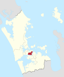
Maungakiekie-Tāmaki ward
Maungakiekie-Tāmaki Ward | |
|---|---|
 | |
| Country | New Zealand |
| Island | North Island |
| Region | Auckland Region |
| Government | |
| • Councillor | Josephine Bartley |
| Area | |
| • Land | 40.39 km2 (15.59 sq mi) |
| Population (June 2024)[2] | |
• Total | 88,200 |
Maungakiekie-Tāmaki Ward is an Auckland Council ward which elects one councillor and covers the Maungakiekie-Tāmaki Local Board. The current councillor is Josephine Bartley.
Demographics
Maungakiekie-Tāmaki ward covers 40.39 km2 (15.59 sq mi)[1] and had an estimated population of 88,200 as of June 2024,[2] with a population density of 2,184 people per km2.
| Year | Pop. | ±% p.a. |
|---|---|---|
| 2006 | 66,372 | — |
| 2013 | 80,346 | +2.77% |
| 2018 | 87,054 | +1.62% |
| 2023 | 88,545 | +0.34% |
| The 2006 population is for a smaller area of 36.38 km2. Source: [3][4] | ||

Maungakiekie-Tāmaki had a population of 88,545 in the 2023 New Zealand census, an increase of 1,491 people (1.7%) since the 2018 census, and an increase of 8,199 people (10.2%) since the 2013 census. There were 43,521 males, 44,655 females and 366 people of other genders in 30,423 dwellings.[5] 3.9% of people identified as LGBTIQ+. The median age was 34.6 years (compared with 38.1 years nationally). There were 16,698 people (18.9%) aged under 15 years, 19,230 (21.7%) aged 15 to 29, 41,898 (47.3%) aged 30 to 64, and 10,719 (12.1%) aged 65 or older.[4]
People could identify as more than one ethnicity. The results were 44.2% European (Pākehā); 13.4% Māori; 23.6% Pasifika; 30.3% Asian; 3.2% Middle Eastern, Latin American and African New Zealanders (MELAA); and 1.5% other, which includes people giving their ethnicity as "New Zealander". English was spoken by 91.8%, Māori language by 2.8%, Samoan by 4.4%, and other languages by 30.3%. No language could be spoken by 2.8% (e.g. too young to talk). New Zealand Sign Language was known by 0.4%. The percentage of people born overseas was 42.5, compared with 28.8% nationally.[4]
Religious affiliations were 40.6% Christian, 4.4% Hindu, 2.6% Islam, 1.1% Māori religious beliefs, 2.6% Buddhist, 0.3% New Age, 0.2% Jewish, and 1.8% other religions. People who answered that they had no religion were 40.6%, and 6.0% of people did not answer the census question.[4]
Of those at least 15 years old, 24,282 (33.8%) people had a bachelor's or higher degree, 28,557 (39.7%) had a post-high school certificate or diploma, and 19,014 (26.5%) people exclusively held high school qualifications. The median income was $46,600, compared with $41,500 nationally. 10,194 people (14.2%) earned over $100,000 compared to 12.1% nationally. The employment status of those at least 15 was that 40,383 (56.2%) people were employed full-time, 7,380 (10.3%) were part-time, and 2,400 (3.3%) were unemployed.[4]
Councillors
| Maungakiekie-Tāmaki Ward councillor of Auckland | |
|---|---|
since 2018 | |
| Term length | Three years |
| Inaugural holder | Richard Northey |
| Formation | 1 November 2010 |
| Website | www.aucklandcouncil.govt.nz |
| Election | Councillors elected | Affiliation | Votes | Notes |
|---|---|---|---|---|
| 2010 | Richard Northey | Labour | 9236 | |
| 2013 | Denise Krum | Communities and Residents | 8483 | |
| 2016[6] | Denise Lee | Auckland Future | 9361[7] | elected as Denise Krum. Reverted to her maiden name, Lee, after the election.[8] Resigned after election to parliament at the 2017 general election, triggering a by-election.[9] |
| 2018 by-election | Josephine Bartley | Labour | 7225 | elected in by-election, 17 February 2018.[10] |
| 2019 | Josephine Bartley | Labour | 8358[11] | |
| 2022 | Josephine Bartley | Labour | 8877[12] |
Election Results
Election Results for the Maungakiekie-Tāmaki Ward:
| Name | Affiliation | Votes | |
|---|---|---|---|
| 1 | Josephine Bartley | Labour | 8877 |
| Troy Elliott | Communities and Residents | 6868 | |
| John Peebles | Independent | 1812 | |
| Christopher Carroll | 1213 | ||
| Blank | 954 | ||
| Informal | 29 | ||
References
- ^ a b "Stats NZ Geographic Data Service". Ward 2023 (generalised). Retrieved 21 February 2025.
- ^ a b "Aotearoa Data Explorer". Statistics New Zealand. Retrieved 26 October 2024.
- ^ "Statistical area 1 dataset for 2018 Census". Statistics New Zealand. March 2020. Maungakiekie-Tāmaki Ward (07609).
- ^ a b c d e "Totals by topic for individuals, (RC, TALB, UR, SA3, SA2, Ward, Health), 2013, 2018, and 2023 Censuses". Stats NZ – Tatauranga Aotearoa – Aotearoa Data Explorer. Maungakiekie-Tāmaki Ward (w_07609). Retrieved 3 October 2024.
- ^ "Totals by topic for dwellings, (RC, TALB, UR, SA3, SA2, Ward, Health), 2013, 2018, and 2023 Censuses". Stats NZ – Tatauranga Aotearoa – Aotearoa Data Explorer. Retrieved 3 October 2024.
- ^ "Local body election nominations close". Radio New Zealand. 12 August 2016. Retrieved 7 December 2017.
- ^ "Ward councillors – Maungakiekie-Tāmaki Ward confirmed" (PDF). Auckland Council. 2016. Retrieved 7 December 2017.
- ^ "Maungakiekie-Tamaki councillor changes name". Stuff. 12 October 2016. Retrieved 7 December 2017.
- ^ "Resignations received from new MPs". Auckland Council. 13 October 2017. Retrieved 17 February 2018.
- ^ "New Auckland Council representatives elected". The New Zealand Herald. February 2018. Retrieved 20 February 2018.
- ^ "Local board members" (PDF). Auckland Council. 18 October 2019. Retrieved 21 October 2019.
- ^ a b "Local Elections 2022 - Official Results" (PDF). Auckland Council. 15 October 2022. Archived (PDF) from the original on 17 October 2022. Retrieved 17 October 2022.
