
File:Tokara-eilanden.png
No higher resolution available.
Tokara-eilanden.png (419 × 175 pixels, file size: 4 KB, MIME type: image/png)
Summary
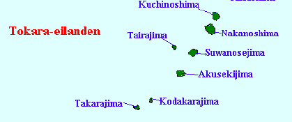
| Description | English: Map of the Tokara Islands, Kagoshima Prefecture, Japan |
||
| Date | (UTC) | ||
| Source | |||
| Author |
|
||
| Other versions |
|

| This is a retouched picture, which means that it has been digitally altered from its original version. The original can be viewed here: Satsunan Islands.png:
|
Licensing
I, the copyright holder of this work, hereby publish it under the following license:
| I, the copyright holder of this work, release this work into the public domain. This applies worldwide. In some countries this may not be legally possible; if so: I grant anyone the right to use this work for any purpose, without any conditions, unless such conditions are required by law. |
Original upload log
This image is a derivative work of the following images:
- File:Satsunan_Islands.png licensed with PD-self
- 2007-01-05T16:16:30Z Krisgrotius 780x1083 (77720 Bytes) {{Information |Description=Map of the Satsunan Islands (Ōsumi Islands + Tokara Islands + Amami Islands), Ryukyu , Japan |Source= own work |Date=~~~~~ |Author=~~~ |Permission= |other_versions= public }}
Uploaded with derivativeFX
File history
Click on a date/time to view the file as it appeared at that time.
| Date/Time | Thumbnail | Dimensions | User | Comment | |
|---|---|---|---|---|---|
| current | 18:55, 1 March 2009 | | 419 × 175 (4 KB) | A1000 | {{Information |Description=Map of the Satsunan Islands (Ōsumi Islands + Tokara Islands + Amami Islands), Ryukyu , Japan |Source=*File:Satsunan_Islands.png |Date=2009-03-01 18:54 (UTC) |Author=*File:Satsunan_Islands.png: [[User:Krisgrotius|Kri |
File usage
The following 6 pages use this file:
Global file usage
The following other wikis use this file:
- Usage on arz.wikipedia.org
- Usage on cs.wikipedia.org
- Usage on de.wikipedia.org
- Usage on es.wikipedia.org
- Usage on fr.wikipedia.org
- Usage on ml.wikipedia.org
- Usage on mr.wikipedia.org
- Usage on no.wikipedia.org
- Usage on pl.wikipedia.org
- Usage on uk.wikipedia.org
- Usage on www.wikidata.org
- Usage on zh-min-nan.wikipedia.org
- Usage on zh-yue.wikipedia.org
- Usage on zh.wikipedia.org