
File:Netherlands Antilles before 1986.png
No higher resolution available.
Netherlands_Antilles_before_1986.png (610 × 351 pixels, file size: 47 KB, MIME type: image/png)
Summary
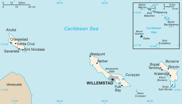
| Description | Map of the Netherlands Antilles before the secession of Aruba in 1986. For a map marking present-day capitals, see File:Dutch Caribbean map.png. |
| Date | (UTC) |
| Source | |
| Author |
|
| This is a retouched picture, which means that it has been digitally altered from its original version. Modifications: scaled Aruba map down and merged the two maps; also drawn part of Venezuela. The original can be viewed here: Aruba map.png:
|
| I, the copyright holder of this work, release this work into the public domain. This applies worldwide. In some countries this may not be legally possible; if so: I grant anyone the right to use this work for any purpose, without any conditions, unless such conditions are required by law. |
This image is in the public domain because it contains materials that originally came from the United States Central Intelligence Agency's World Factbook.
|
 |
Original upload log
This image is a derivative work of the following images:
- File:Netherlands_Antilles-CIA_WFB_Map.png licensed with PD-USGov-CIA-WF
- 2010-08-05T22:44:53Z Ras67 326x351 (8142 Bytes) cropped
- 2006-01-30T09:05:54Z Hoshie 329x353 (9943 Bytes) Updated map of the Netherlands Antilles from the CIA Factbook, 10 Jan 06 rev: http://www.cia.gov/cia/publications/factbook/maps/nt-map.gif
- 2005-03-27T09:16:44Z Wolfman 329x354 (5820 Bytes) {{CIA-map}}
- File:Aruba_map.png licensed with PD-USGov-CIA-WF
Uploaded with derivativeFX
File history
Click on a date/time to view the file as it appeared at that time.
| Date/Time | Thumbnail | Dimensions | User | Comment | |
|---|---|---|---|---|---|
| current | 11:42, 20 December 2011 | | 610 × 351 (47 KB) | Thayts | Minor readability issue |
| 11:04, 8 September 2011 |  | 610 × 351 (47 KB) | Thayts | Smoothened edge | |
| 19:58, 7 September 2011 |  | 610 × 351 (46 KB) | Thayts | {{Information |Description=Map of the Netherlands Antilles before the secession of Aruba in 1986. |Source=*File:Netherlands_Antilles-CIA_WFB_Map.png *File:Aruba_map.png |Date=2011-09-07 19:57 (UTC) |Author=*[[:File:Netherlands_Antilles-CIA_WFB |
File usage
The following 3 pages use this file:
Global file usage
The following other wikis use this file:
- Usage on ast.wikipedia.org
- Usage on ast.wiktionary.org
- Usage on azb.wikipedia.org
- Usage on es.wikipedia.org
- Usage on gl.wikipedia.org
- Usage on io.wikipedia.org
- Usage on ja.wikipedia.org
- Usage on ko.wikipedia.org