
File:NGA-GEOINT.png

Size of this preview: 800 × 594 pixels. Other resolutions: 320 × 238 pixels | 640 × 476 pixels | 1,024 × 761 pixels | 1,339 × 995 pixels.
Original file (1,339 × 995 pixels, file size: 1.18 MB, MIME type: image/png)
Summary
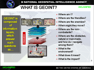
| Description | English: Graphic illustrating the definition of Geospatial Intelligence (GEOINT) |
|||
| Date | Unknown date | |||
| Source | Graphic was extracted from http://slideplayer.com/slide/4175372/ of a National Geospatial-Intelligence Agency (NGA) presentation that was presented to a public forum | |||
| Author | NGA | |||
| Permission (Reusing this file) |
|

Licensing
Original upload log
The original description page was here. All following user names refer to en.wikipedia.
| Date/Time | Dimensions | User | Comment |
|---|---|---|---|
| 2018-04-24 20:56:45 | 1339 × 995 | McChizzle | {{Information |Description=Graphic illustrating the definition of [[Geospatial Intelligence]] (GEOINT) |Source= Graphic was extracted from http://slideplayer.com/slide/4175372/ of a [[National Geospatial-Intelligence Agency]] (NGA) presentation that was presented to a public forum |Date=Unknown |Author=NGA |Permission={{PD-USGov-Military}} |other versions= }} |
File history
Click on a date/time to view the file as it appeared at that time.
| Date/Time | Thumbnail | Dimensions | User | Comment | |
|---|---|---|---|---|---|
| current | 02:37, 25 July 2018 | | 1,339 × 995 (1.18 MB) | FSock | Transferred from en.wikipedia (MTC!) (1.1.1) |
File usage
The following page uses this file:
Global file usage
The following other wikis use this file:
- Usage on ar.wikipedia.org
- Usage on fr.wikipedia.org
- Usage on ro.wikipedia.org