
File:Metromoves-map.jpg
No higher resolution available.
Metromoves-map.jpg (348 × 298 pixels, file size: 31 KB, MIME type: image/jpeg)
| Description |
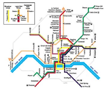
A low resolution map of the MetroMoves mass transit plan. |
|---|---|
| Source |
Derived from a screen shot of http://www.pro-transit.com/pdf/regionalrailplan.pdf |
| Article | |
| Portion used |
All |
| Low resolution? |
Yes |
| Purpose of use |
This image serves as the primary means to describe the light rail, commuter rail, and streetcar proposal by the Southwest Ohio Regional Transit Authority. |
| Replaceable? |
This image can not be replaced by another image because no portion of the MetroMoves plan was ever implemented. Therefore, the only visual means that's available to describe the plan is that which was released by SORTA. |
| Fair useFair use of copyrighted material in the context of MetroMoves//en.wikipedia.org/wiki/File:Metromoves-map.jpgtrue | |
Licensing
File history
Click on a date/time to view the file as it appeared at that time.
| Date/Time | Thumbnail | Dimensions | User | Comment | |
|---|---|---|---|---|---|
| current | 03:52, 11 July 2008 | | 348 × 298 (31 KB) | J.H (talk | contribs) | {{Non-free use rationale |Article=MetroMoves |Description=A low resolution map of the MetroMoves mass transit plan. |Source=Derived from a screen shot of http://www.pro-transit.com/pdf/regionalrailplan.pdf |Portion=All |Low_resolution=Yes |Purpose=This im |
You cannot overwrite this file.
File usage
The following page uses this file: