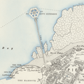
File:Margate jetty circa 1892 map.png

Size of this preview: 600 × 600 pixels. Other resolutions: 240 × 240 pixels | 480 × 480 pixels | 779 × 779 pixels.
Original file (779 × 779 pixels, file size: 1.01 MB, MIME type: image/png)
File history
Click on a date/time to view the file as it appeared at that time.
| Date/Time | Thumbnail | Dimensions | User | Comment | |
|---|---|---|---|---|---|
| current | 11:43, 15 March 2021 |  | 779 × 779 (1.01 MB) | Dumelow | == {{int:filedesc}} == {{Information |Description=Margate Jetty from OS mapping |Source=https://maps.nls.uk/ |Date= Map circa 1892 |Author=Ordnance Survey |Permission= |other_versions= }} {{Template:PD-UKGov}} |
File usage
The following page uses this file:

