
File:LafayetteIN1868.JPG

Original file (4,400 × 3,400 pixels, file size: 3.97 MB, MIME type: image/jpeg)
Information
| Description |
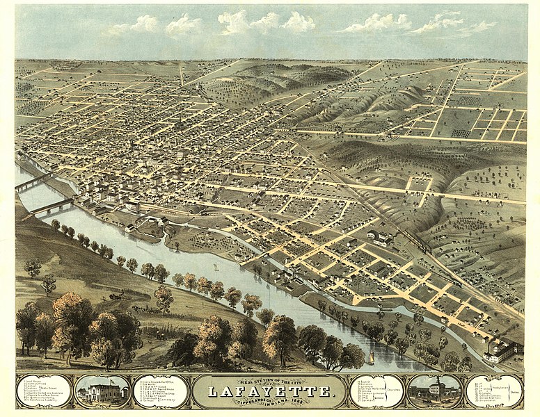
This panoramic map from LC Panoramic maps (2nd ed.), page 2, illustrates a bird's-eye view of Lafayette, Indiana in 1868. Drawn 1868 by A. Ruger and published in Chicago by Chicago Lith. Co., the perspective map is indexed for points of interest. NOTES: Perspective map not drawn to scale. Includes ill. and index to points of interest. Medium: col. map 56 x 70 cm. Call Number: G4094.L2A3 1868 .R8 Rug 43 .G6. Reference: LC Panoramic maps (2nd ed.), 197 Repository: Library of Congress Geography and Map Division Washington, D.C. 20540-4650 USA. Digital ID: g4094l pm001970 |
|---|---|
| Source |
Library of Congress Geography and Map Division, Washington, D.C. 20540-4650 |
| Date |
1868 |
| Author |
A. Ruger |
| Permission (Reusing this file) |
Public Domain
|
40°24′32″N 86°54′42″W / 40.40889°N 86.91167°W
Licensing:
File history
Click on a date/time to view the file as it appeared at that time.
| Date/Time | Thumbnail | Dimensions | User | Comment | |
|---|---|---|---|---|---|
| current | 07:45, 18 August 2008 | | 4,400 × 3,400 (3.97 MB) | Suntag (talk | contribs) |
You cannot overwrite this file.
File usage
The following page uses this file: