
File:FortDavisCampaignMap.jpg
FortDavisCampaignMap.jpg (290 × 344 pixels, file size: 21 KB, MIME type: image/jpeg)
Summary
| Description |
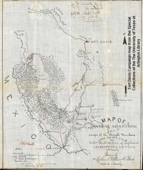
A photo of a black and white hand drawn map from 1880 showing Fort Davis and the Chinati Mountains used during military campaigns against the Apache Indians led by Victorio. |
|---|---|
| Source |
Special Collections, The University of Texas at Arlington Library |
| Article | |
| Portion used |
no |
| Low resolution? |
yes |
| Purpose of use |
For use in articles related to the description of the map. |
| Replaceable? |
Only known image of map partly commissioned by Louis H. Carpenter |
| Other information | |
| Fair useFair use of copyrighted material in the context of Louis H. Carpenter//en.wikipedia.org/wiki/File:FortDavisCampaignMap.jpgtrue | |
| Description |
A photo of a black and white hand drawn map from 1880 showing Fort Davis and the Chinati Mountains used during military campaigns against the Apache Indians led by Victorio. |
|---|---|
| Source |
Special Collections, The University of Texas at Arlington Library |
| Article | |
| Portion used |
no |
| Low resolution? |
yes |
| Purpose of use |
For use in articles related to the description of the map. |
| Replaceable? |
Only known image of map partly commissioned by Louis H. Carpenter |
| Other information | |
| Fair useFair use of copyrighted material in the context of Fort Davis National Historic Site//en.wikipedia.org/wiki/File:FortDavisCampaignMap.jpgtrue | |
| Description |
A photo of a black and white hand drawn map from 1880 showing Fort Davis and the Chinati Mountains used during military campaigns against the Apache Indians led by Victorio. |
|---|---|
| Source |
Special Collections, The University of Texas at Arlington Library |
| Article | |
| Portion used |
no |
| Low resolution? |
yes |
| Purpose of use |
For use in articles related to the description of the map. |
| Replaceable? |
Only known image of map partly commissioned by Louis H. Carpenter |
| Other information | |
| Fair useFair use of copyrighted material in the context of University of Texas at Arlington//en.wikipedia.org/wiki/File:FortDavisCampaignMap.jpgtrue | |
Licensing:
File history
Click on a date/time to view the file as it appeared at that time.
| Date/Time | Thumbnail | Dimensions | User | Comment | |
|---|---|---|---|---|---|
| current | 02:40, 30 May 2017 | | 290 × 344 (21 KB) | DatBot (talk | contribs) | Reduce size of non-free image (BOT - disable) |
| 14:57, 26 August 2009 | No thumbnail | 475 × 564 (111 KB) | Jrcrin001 (talk | contribs) | {{Non-free use rationale |Article = Louis H. Carpenter |Description = A photo of a black and white hand drawn map from 1880 showing Fort Davis and the Chinati Mountains used during military campaigns against the Apache Indians led by Vic |
You cannot overwrite this file.
File usage
The following 2 pages use this file: