Downey, Iowa
Downey, Iowa | |
|---|---|
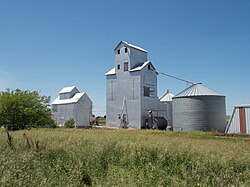
 Grain bins along the Iowa Interstate railroad tracks in Downey | |
| Coordinates: 41°36′58″N 91°20′55″W / 41.61611°N 91.34861°W | |
| Country | United States |
| State | Iowa |
| County | Cedar |
| Township | Springdale |
| Area | |
• Total | 0.68 sq mi (1.75 km2) |
| • Land | 0.68 sq mi (1.75 km2) |
| • Water | 0.00 sq mi (0.00 km2) |
| Elevation | 689 ft (210 m) |
| Population (2020) | |
• Total | 112 |
| • Density | 165.93/sq mi (64.04/km2) |
| Time zone | UTC-6 (Central (CST)) |
| • Summer (DST) | UTC-5 (CDT) |
| ZIP code | 52358[2] |
| Area code | 319 |
| GNIS feature ID | 455974[3] |
Downey is an unincorporated community in Cedar County, Iowa, United States.[3]
Demographics
| Census | Pop. | Note | %± |
|---|---|---|---|
| 2020 | 112 | — | |
| U.S. Decennial Census[4] | |||
History
Downey was established in 1856, the spring after the Chicago, Rock Island and Pacific Railroad was built through it, though the area had first been settled in 1836.[5] Downey is named for its founder, Hugh D. Downey.[6]
Downey's population was 100 in 1902,[7] and 105 in 1925.[8] The population was 111 in 1940.[9]
References
- ^ "2020 U.S. Gazetteer Files". United States Census Bureau. Retrieved March 16, 2022.
- ^ "Downey IA ZIP Code". zipdatamaps.com. 2024. Retrieved February 5, 2024.
- ^ a b "Downey". Geographic Names Information System. United States Geological Survey, United States Department of the Interior.
- ^ "Census of Population and Housing". Census.gov. Retrieved June 4, 2016.
- ^ The History of Cedar County, Iowa: Containing a History of the County, Its Cities, Towns, etc. Western Historical Company. 1878. p. 512.
- ^ Aurner, Clarence Ray (1910). A Topical History of Cedar County, Iowa, Volume 1. S. J. Clarke. pp. 129.
- ^ Cram's Modern Atlas: The New Unrivaled New Census Edition. J. R. Gray & Company. 1902. pp. 203–207.
- ^ Premier Atlas of the World: Containing Maps of All Countries of the World, with the Most Recent Boundary Decisions, and Maps of All the States, territories, and Possessions of the United States with Population Figures from the Latest Official Census Reports, Also Data of Interest Concerning International and Domestic Political Questions. Rand McNally & Company. 1925. p. 190.
- ^ The Attorneys List. United States Fidelity and Guaranty Company, Attorney List Department. 1940. p. 298.


