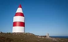
Daymark


A daymark is a navigational aid for sailors and pilots, distinctively marked to maximize its visibility in daylight.[1]
The word is also used in a more specific, technical sense to refer to a signboard or daytime identifier that is attached to a day beacon or other aid to navigation.[2] In that sense, a daymark conveys to the mariner during daylight hours the same significance as the aid's light or reflector does at night.[3] Standard signboard shapes are square, triangular, and rectangular, while the standard colours are red, green, orange, yellow, and black.[2]
Notable daymarks
- Trinity House Obelisk, UK
- Kingswear Daymark, UK
- Tasku beacon tower, Finland
- Keskiniemi beacon tower, Finland
- Hiidenniemi beacon tower, Finland
- Laitakari beacon tower, Finland
- Herring Tower, Langness, Isle of Man
- Le Hocq, Jersey
- La Tour Cârrée, Jersey
- Scharhörnbake, Germany
Symbols used on US charts
Chart symbols used by the US National Oceanic and Atmospheric Administration Department, 2013.[4]
| Paper chart | Simplified | Simplified symbol name |
|---|---|---|

|
Square or rectangular daymark | |

|
Triangular daymark, point up | |

|

|
Triangular daymark, point down |
| Retro reflector |
See also
References
- ^ "daymark". Oxford English Dictionary (Online ed.). Oxford University Press. Retrieved 2021-10-04. (Subscription or participating institution membership required.)
- ^ a b "Nautical Terms for boating and marine industry terminology". www.marineinstitute.org. Archived from the original on 2003-12-17. Retrieved 2017-03-08.
- ^ Light List, Volume II, Atlantic Coast. Washington, DC: US Government Printing Office. 2015. pp. ix.
- ^ US Chart No. 1: Symbols, Abbreviations and Terms used on Paper and Electronic Navigational Charts. Department of Commerce National Oceanic and Atmospheric Administration Department of Defense National Geospatial-Intelligence Agency. 2013. p. 86.
External links
 The dictionary definition of daymark at Wiktionary

