
Datei:Danishmend 1097, locator map.svg

Größe der PNG-Vorschau dieser SVG-Datei: 800 × 417 Pixel. Weitere aus SVG automatisch erzeugte PNG-Grafiken in verschiedenen Auflösungen: 320 × 167 Pixel | 640 × 333 Pixel | 1.024 × 533 Pixel | 1.280 × 667 Pixel | 2.560 × 1.333 Pixel | 1.440 × 750 Pixel
Originaldatei (SVG-Datei, Basisgröße: 1.440 × 750 Pixel, Dateigröße: 209 KB)
![]()
Diese Datei und die Informationen unter dem roten Trennstrich werden aus dem zentralen Medienarchiv Wikimedia Commons eingebunden.
![]()
Beschreibung
| Beschreibung |
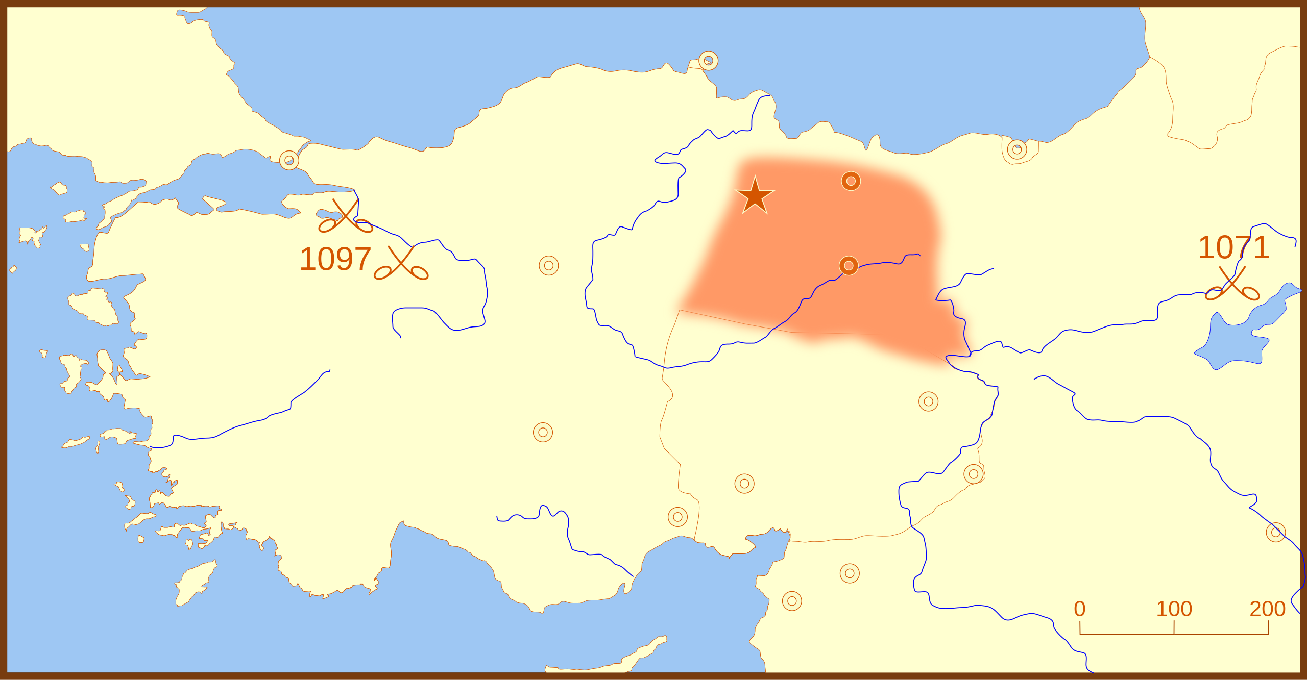
A locator map for the Danishmend territories, as of 1097. This map also shows locations for the following battles:
|
| Datum | |
| Quelle | Eigenes Werk |
| Urheber | MapMaster |
Other versions
References
- Hammond World Atlas Corporation (2007) Historical World Atlas, ISBN 9-780843-71391-6
Lizenz
Ich, der Urheberrechtsinhaber dieses Werkes, veröffentliche es hiermit unter der folgenden Lizenz:

|
Es ist erlaubt, die Datei unter den Bedingungen der GNU-Lizenz für freie Dokumentation, Version 1.2 oder einer späteren Version, veröffentlicht von der Free Software Foundation, zu kopieren, zu verbreiten und/oder zu modifizieren; es gibt keine unveränderlichen Abschnitte, keinen vorderen und keinen hinteren Umschlagtext.
Der vollständige Text der Lizenz ist im Kapitel GNU-Lizenz für freie Dokumentation verfügbar. |
Diese Datei ist unter den Creative Commons-Lizenzen Namensnennung – Weitergabe unter gleichen Bedingungen 4.0 International, 3.0 nicht portiert, 2.5 Allgemein, 2.0 Allgemein und 1.0 Allgemein lizenziert.
- Dieses Werk darf von dir
- verbreitet werden – vervielfältigt, verbreitet und öffentlich zugänglich gemacht werden
- neu zusammengestellt werden – abgewandelt und bearbeitet werden
- Zu den folgenden Bedingungen:
- Namensnennung – Du musst angemessene Urheber- und Rechteangaben machen, einen Link zur Lizenz beifügen und angeben, ob Änderungen vorgenommen wurden. Diese Angaben dürfen in jeder angemessenen Art und Weise gemacht werden, allerdings nicht so, dass der Eindruck entsteht, der Lizenzgeber unterstütze gerade dich oder deine Nutzung besonders.
- Weitergabe unter gleichen Bedingungen – Wenn du das Material wiedermischst, transformierst oder darauf aufbaust, musst du deine Beiträge unter der gleichen oder einer kompatiblen Lizenz wie das Original verbreiten.
Du darfst es unter einer der obigen Lizenzen deiner Wahl verwenden.
Dateiversionen
Klicke auf einen Zeitpunkt, um diese Version zu laden.
| Version vom | Vorschaubild | Maße | Benutzer | Kommentar | |
|---|---|---|---|---|---|
| aktuell | 04:32, 26. Feb. 2008 | | 1.440 × 750 (209 KB) | MapMaster | Added Battle of Dorylaeum |
| 03:49, 26. Feb. 2008 |  | 1.440 × 750 (187 KB) | MapMaster | more edits | |
| 06:00, 25. Feb. 2008 |  | 1.440 × 750 (184 KB) | MapMaster | minor edits | |
| 00:20, 25. Feb. 2008 |  | 1.440 × 750 (184 KB) | MapMaster | {{Information |Description=A locator map for the Danishmend territories, as of 1097. |Source=self-made |Date=24 February 2008 |Author= MapMaster |Permission= |other_versions= }} |
Dateiverwendung
Die folgenden 4 Seiten verwenden diese Datei:
Globale Dateiverwendung
Die nachfolgenden anderen Wikis verwenden diese Datei:
- Verwendung auf ar.wikipedia.org
- Verwendung auf bg.wikipedia.org
- Verwendung auf br.wikipedia.org
- Verwendung auf el.wikipedia.org
- Verwendung auf es.wikipedia.org
- Verwendung auf fr.wikipedia.org
- Verwendung auf id.wikipedia.org
- Verwendung auf it.wikipedia.org
- Verwendung auf pt.wikipedia.org
- Verwendung auf tr.wikipedia.org
- Verwendung auf uz.wikipedia.org