
File:Amesbury station site geograph-3232089-by-Ben-Brooksbank.jpg

Size of this preview: 800 × 488 pixels. Other resolutions: 320 × 195 pixels | 640 × 390 pixels | 1,024 × 624 pixels | 1,280 × 781 pixels | 2,394 × 1,460 pixels.
Original file (2,394 × 1,460 pixels, file size: 2.72 MB, MIME type: image/jpeg)
Summary
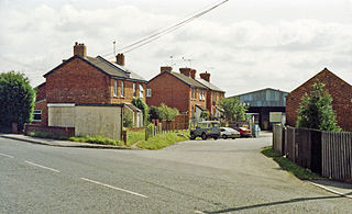
| Description | English: Site of Amesbury station, 1992. View eastward beside the (old) A303, towards Newton Tony and the triangular junctions with the ex-LSW London - Salisbury etc. main line near Porton: ex-LSW branch to Bulford and Bulford Camp; all closed to passengers 30/6/52, goods 4/3/63. |
| Date | |
| Source | From geograph.org.uk |
| Author | Ben Brooksbank |
| Permission (Reusing this file) |
Creative Commons Attribution Share-alike license 2.0 |
| Attribution (required by the license) | Ben Brooksbank / Site of Amesbury station, 1992 / |
| Camera location | | View this and other nearby images on: OpenStreetMap |
|---|
Licensing

|
This image was taken from the Geograph project collection. See this photograph's page on the Geograph website for the photographer's contact details. The copyright on this image is owned by Ben Brooksbank and is licensed for reuse under the Creative Commons Attribution-ShareAlike 2.0 license. |
This file is licensed under the Creative Commons Attribution-Share Alike 2.0 Generic license.
Attribution: Ben Brooksbank
- You are free:
- to share – to copy, distribute and transmit the work
- to remix – to adapt the work
- Under the following conditions:
- attribution – You must give appropriate credit, provide a link to the license, and indicate if changes were made. You may do so in any reasonable manner, but not in any way that suggests the licensor endorses you or your use.
- share alike – If you remix, transform, or build upon the material, you must distribute your contributions under the same or compatible license as the original.
File history
Click on a date/time to view the file as it appeared at that time.
| Date/Time | Thumbnail | Dimensions | User | Comment | |
|---|---|---|---|---|---|
| current | 21:55, 23 November 2012 | | 2,394 × 1,460 (2.72 MB) | Chevin | == {{int:filedesc}} == {{Information |Description={{en|1='''Site of Amesbury station, 1992.'''<br/> View eastward beside the (old) A303, towards Newton Tony and the triangular junctions with the ex-LSW London - Salisbury etc. main line near Porton: ex-... |
File usage
The following page uses this file:
Global file usage
The following other wikis use this file:
- Usage on www.wikidata.org