
Ramat Yishai
Ramat Yishai
| |
|---|---|
Local council (from 1958) | |
| Hebrew transcription(s) | |
| • ISO 259 | Ramat Yiššay |
 View of Ramat Yishai from the west | |
 Ramat Yishai | |
| Coordinates: 32°42′12″N 35°9′54″E / 32.70333°N 35.16500°E | |
| Grid position | 166/234 PAL |
| District | Northern |
| Founded | 1925 |
| Government | |
| • Head of Municipality | Ofer Ben-Eliezer |
| Area | |
• Total | 2,388 dunams (2.388 km2 or 590 acres) |
| Population (2022)[1] | |
• Total | 8,120 |
| • Density | 3,400/km2 (8,800/sq mi) |
| Ethnicity | |
| • Jews and others | 99.9% |
| • Arabs | 0.1% |
Ramat Yishai (Hebrew: רָמַת יִשַּׁי, Jesse's Heights; Arabic: رمات يشاي) is a town in the Northern District of Israel, located on the side of the Haifa–Nazareth road about 4 kilometres (2.5 mi) eastern to Kiryat Tivon. It was established in 1925 on land purchased from the Arab village of Jeida. The town achieved local council status in 1958. In 2022 it had a population of 8,120.
Name
The town and local council are named Ramat Yishai, literaly Jesse's Heights. The town is named for the Jewish teacher and philanthropist Yisrael Yehudah "Yishai" Adler, which was among the founders of Tel Aviv, and who donated funds that were crucial to the town's survival after it was raided by Arabs during the 1936–39 Arab revolt in Palestine.[2]
Adler's first name, Yisrael Yehudah, can be shortened in Hebrew to Yis-Y, written יִשַּׁ"י and pronouneced Yishai. The town's is occasionally mistakingly mentioned as being named after the biblical figure, Jesse, King David's father, whose name is also pronouned Yishai in Hebrew.
History
Archaeological remnants have been found from Middle Bronze Age I (a tomb) and the Roman, Byzantine, Umayyad and Abbasid eras. Of particular interest, was a zoomorphic vessel of glass, dating to the Umayyad era.[3] Remains from the Crusades, as well as from the Mamluk era has also been found here.[3]
In 1875 Victor Guérin found rock-cut cisterns in the area that have been repeatedly dug up, concluding that the archelogical site must be an ancient one. Guérin identified the site with the ancient Israelite city of Idalah, a part of the inheritance of the Tribe of Zebulon.[4][5][6]
Ottoman era
During the Ottoman era, an Arab village existed on the lands where Ramat Yishai is currently located. the village's name was Jeida (sometimes spelled in English as Jayda[7], Geida[8] or Jedda[9]) which possibly meant "long-necked" in Arabic as a description of a previous inhabitant of the village or land,[10] or an Arabicization of the Hebrew name Idalah.
Jeida was first mentioned in the Ottoman defter for the year 1555-6, named Jayda, located in the Nahiya of Tabariyya of the Liwa of Safad, and with its land designated as Ziamet land.[7] The village appeared as Geida on the map which Pierre Jacotin compiled in 1799.[8] In 1881, the PEF's Survey of Western Palestine (SWP) found that the village was much like the nearby village Al-Harithiyah, described as "A miserable hamlet of mud". A spring was mentioned to be 3/4 of a mile to the west.[11]

around the late 19th century, the lands of the village were acquired by the Twsiny family, which partnered with the Lebanese Greek Orthodox Christian Sursuk family from Beirut. the landowners either finanaced the construction or the renovation of the Ramat Yishai Khan, after which it was used as the residence of the foreman who oversaw farmhands working their lands. The building was colloquially identified as a persian Khan, a travlers' inn.[12][13]
British Mandate era

In 1925, the Twsiny and Sursuk families sold a total of 15,000 dunams to a Zionist organization, which later sold it to the "Manor" society, an association of Polish-Jewish immigrant families that intended to create a socialist textile factory in Palestine, similar to the New Lanark project in Scotland.[9][14][15]
The Manor Society founded a textile mill on the lands, and additional 18 shacks used as housing for the mill's workers, a shared kitchen, a school, and a cow shed. five shallow wells were dug to provide drinking water for the 251 factory workers that moved to the land by 1926.[15] The mill was initially unsuccessful. by 1928 the mill was sold by auction, and only 22 families remained in the village,[16] working mostly in grain agriculture, with a fludgling milking industry.[17] in 1933 the textile mill was leased by German investors of the Nul company, and revived.[18]
During the Arab Revolt the isolated Jewish population was subject to constant attacks, sniper fire and ambushes from armed militias of local Arabs. On 12 October 1936 the villager Mordechai Feldman was ambushed and killed. On the night of 5 June 1938, armed Arabs attacked the Jews in the village again, killed one of the volunteer notrim, Zvi Levine, wounded another, and burned down the textile factory and other buildings.[19][20] Due to the attacks, the village was almost abandoned, with the 9 remaining families abandoning their homes to live in the Khan, and petitioned Zionist organizations to provide relief.[21]
in 1943, on of Tel Aviv's founders, the Jewish philanthropist Yisrael Yehudah "Yishai" Adler pledged a donation of 10,000 Palestine pounds to costruct permanent homes for the textile mill workers and public buildings in the village. The village was renamed in his honour shortly thereafter.[2] Construction began in January 25, 1944.[22] A synogauge and clinic were built in 1947.[23]
State of Israel
by 1949, the village grew to a total of 45 families, mostly employed by the textile mill.[24] in 1950 a 200-family Ma'abara, a refugee tent city, was created by the state nearby.[25] Three years later the tent city was demolished as the refugees were resettled in Migdal Haemek.[26]
Since the 1990s, Ramat Yishai has undergone rapid development. In 2010, the population was estimated at close to 7,000 people, with 1,800 households at the high end of the socioeconomic scale.[9]
Culture and Notable Landmarks
One of the better known buildings in the village is called "the Khan" (caravanserai in Arabic), a 1909 building with surrounding walls. The logo of the village consists of this Ottoman-era building with a palm tree next to it. The town hall flies 2 logo-on-bedsheet flags with this emblem in dark blue on a light blue and a yellow field, respectively. [citation needed]
Demographics
| Town of Ramat Yishai Population by year | |
| 1859 | 120 |
| 1887 | 140 |
| 1922 | 327 |
| 1931 | 115 |
| 1937 | 78 |
| 1945 | 50 |
| 2010 | ~7,000 |
| 2022 | 8,120 |
| 2025 | 7,998 |
In 1859, the village of Jeida was estimated to have 120 inhabitants, and the tillage was 20 feddans.[11] A population list from about 1887 showed that Jeida had about 140 inhabitants; all Muslims.[27] In the 1922 census of Palestine conducted by the British Mandate authorities, Jaida had a total population of 327; 324 Muslims and 3 Christians;[28] of which two were Roman Catholics and one was Melkite Catholic.[29]
A 1926 newspaper report claimed that a total of 251 Jews inhabited the land.[15] At the time of the 1931 census, Jaida had 29 occupied houses and a population of 77 Jews, 2 Christians, and 33 Muslims; a total of 115.[30] In mid-1937, the overall estimated population of 78 included 43 non-Jews and 35 Jews.[31] In the 1945 statistics, Ramat Yishai had 50 residents, all Jewish. It was noted that it was previously called Jeida.[32][33]
in the 2010 Ramat Yishai experienced a minor population boom, driven by families moving from larger cities, motivated by the improving transportation infrastructure in the region[9]
External links
- Ramat Yishai Official website
- Survey of Western Palestine, Map 5: IAA, Wikimedia commons
Notable residents
- Tzahi Elihen, footballer
- Itay Shechter, footballer
References
- ^ a b "Regional Statistics". Israel Central Bureau of Statistics. Retrieved 21 March 2024.
- ^ a b Jeida - Ramat Yishai, Davar (Sept. 8, 1943)
- ^ a b Porat, 06/02/2007, Ramat Yishay
- ^ Guérin, 1880, p. 392
- ^ Conder and Kitchener, 1881, SWP I, p. 308
- ^ Idalah is mentioned in Book of Joshua 19:15, "Included were Kattath, Nahalal, Shimron, Idalah, and Bethlehem; there were twelve cities, along with their villages."
- ^ a b Rohde, 1979, p. 82
- ^ a b Karmon, 1960, p. 163]Archived 2019-12-22 at the Wayback Machine
- ^ a b c d Betting on the Trans-Israel Highway The Jerusalem Post
- ^ According to Palmer, 1881, p. 109
- ^ a b Conder and Kitchener, 1881, SWP I, p. 270
- ^ Esther Nitzani, The Khan that Survived in the Valley, Davar (Nov. 3, 1975)
- ^ Zeev Vilnai, The Building in Ramat Yishai, Davar (Nov. 14, 1975)
- ^ List of villages sold by Sursocks and their partners to the Zionists since British occupation of Palestine, evidence to the Shaw Commission, 1930
- ^ a b c 'Manor' Moshav in Jida, Davar (Aug. 12, 1926)
- ^ Industry in Jeida, Davar (Sept. 2, 1928)
- ^ In the Emek: Jeida, Davar (Sept. 2, 1930)
- ^ In the Village: Jeida Textile Mill in New hands, Davar (Oct. 2, 1933)
- ^ Zeev Aner (1994) Stories from Eretz Israel,
- ^ Zvi Levine Izkor
- ^ Yeruham, What Will Become of Jeida?, Davar (Aug. 16, 1938)
- ^ Ramat Yishai Homes' Cornerstone, Davar (Jan. 26, 1944)
- ^ [-- In the Village: A Double Celebration in Ramat Yishai], Davar (Aug. 24, 1947)
- ^ Lack of Housing Limits Aliya to Ramat Yishai, Davar (May 24, 1949)
- ^ Olim Camp in Nahalal, Davar (June 21, 1950)
- ^ The Town Founded by Mistake - And Doomed to Fail, Maariv (Jan. 9, 1959)
- ^ Schumacher, 1888, p. 175
- ^ Barron, 1923, Table XI, Sub-District of Haifa, p. 33
- ^ Barron, 1923, Table XVI, p. 49
- ^ Mills, 1932, p. 92
- ^ Government of Palestine, Department of Statistics, Village Statistics, Feb. 1938, p.24.
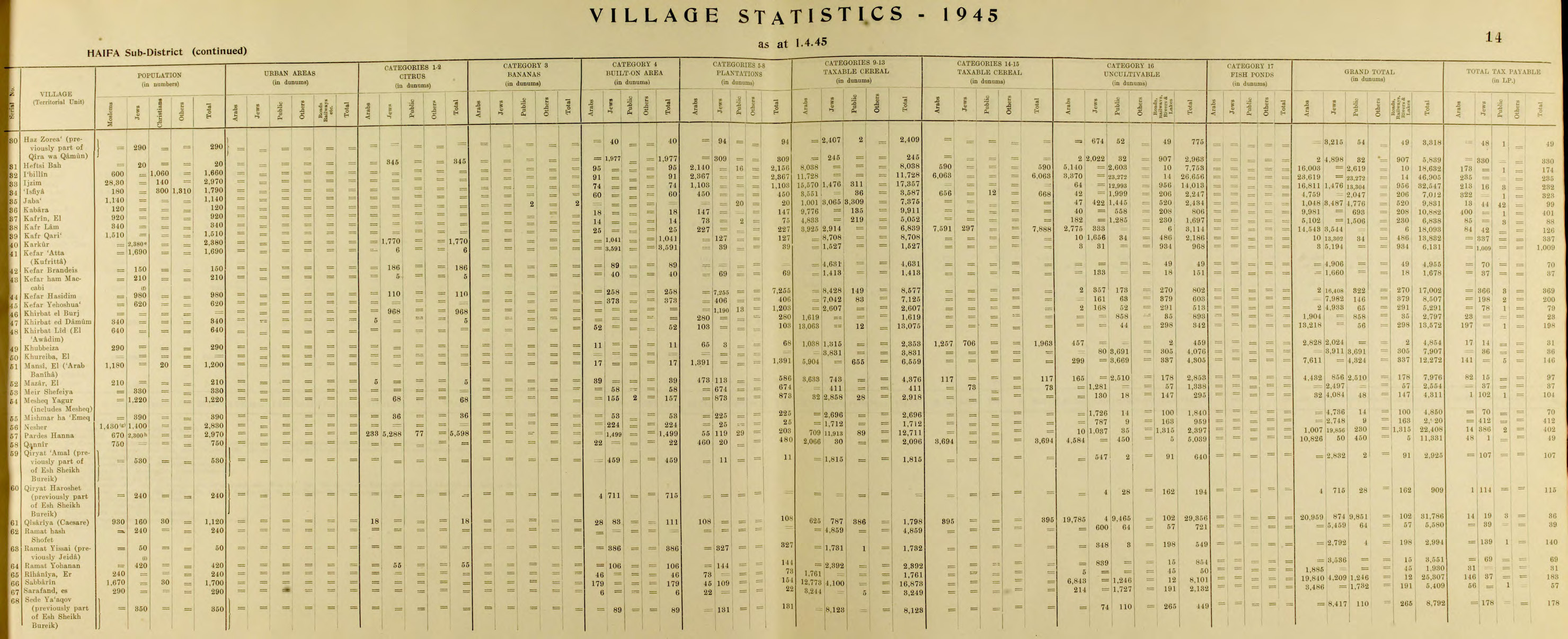
- ^ Government of Palestine, Department of Statistics, 1945, p. 14
- ^ Government of Palestine, Department of Statistics. Village Statistics, April, 1945. Quoted in Hadawi, 1970, p. 49
Bibliography
- Atrash, Walid; Hanna, Butros (2016-04-17). "Ramat Yishay" (128). Hadashot Arkheologiyot – Excavations and Surveys in Israel.
{{cite journal}}: Cite journal requires|journal=(help) - Barron, J.B., ed. (1923). Palestine: Report and General Abstracts of the Census of 1922. Government of Palestine.
- Bisharat, Eyad (2016-03-07). "Ramat Yishay" (128). Hadashot Arkheologiyot – Excavations and Surveys in Israel.
{{cite journal}}: Cite journal requires|journal=(help) - Conder, C.R.; Kitchener, H.H. (1881). The Survey of Western Palestine: Memoirs of the Topography, Orography, Hydrography, and Archaeology. Vol. 1. London: Committee of the Palestine Exploration Fund.
- Daniel, Zohar (2010-06-18). "Ramat Yishay" (122). Hadashot Arkheologiyot – Excavations and Surveys in Israel.
{{cite journal}}: Cite journal requires|journal=(help) - Government of Palestine, Department of Statistics (1945). Village Statistics, April, 1945.
- Guérin, V. (1880). Description Géographique Historique et Archéologique de la Palestine (in French). Vol. 3: Galilee, pt. 1. Paris: L'Imprimerie Nationale.
- Hadawi, S. (1970). Village Statistics of 1945: A Classification of Land and Area ownership in Palestine. Palestine Liberation Organization Research Centre.
- Hanna, Butros (2010-06-18). "Ramat Yishay (South)" (122). Hadashot Arkheologiyot – Excavations and Surveys in Israel.
{{cite journal}}: Cite journal requires|journal=(help) - Hanna, Butros (2012-10-31). "Ramat Yishay (A)" (124). Hadashot Arkheologiyot – Excavations and Surveys in Israel.
{{cite journal}}: Cite journal requires|journal=(help) - Hanna, Butros (2012-10-31). "Ramat Yishay (B)" (124). Hadashot Arkheologiyot – Excavations and Surveys in Israel.
{{cite journal}}: Cite journal requires|journal=(help) - Hanna, Butros (2013-08-26). "Ramat Yishay, Ha-Oren St. (A)" (125). Hadashot Arkheologiyot – Excavations and Surveys in Israel.
{{cite journal}}: Cite journal requires|journal=(help) - Karmon, Y. (1960). "An Analysis of Jacotin's Map of Palestine" (PDF). Israel Exploration Journal. 10 (3, 4): 155–173, 244–253. Archived from the original (PDF) on 2019-12-22. Retrieved 2015-11-30.
- Mills, E., ed. (1932). Census of Palestine 1931. Population of Villages, Towns and Administrative Areas. Jerusalem: Government of Palestine.
- Palmer, E.H. (1881). The Survey of Western Palestine: Arabic and English Name Lists Collected During the Survey by Lieutenants Conder and Kitchener, R. E. Transliterated and Explained by E.H. Palmer. Committee of the Palestine Exploration Fund.
- Porat, Leea (2005-11-13). "Ramat Yishay" (117). Hadashot Arkheologiyot – Excavations and Surveys in Israel.
{{cite journal}}: Cite journal requires|journal=(help) - Porat, Leea (2007-02-06). "Ramat Yishay" (119). Hadashot Arkheologiyot – Excavations and Surveys in Israel.
{{cite journal}}: Cite journal requires|journal=(help) - Rhode, H. (1979). Administration and Population of the Sancak of Safed in the Sixteenth Century. Columbia University. Archived from the original on 2020-03-01. Retrieved 2017-12-28.
- Schumacher, G. (1888). "Population list of the Liwa of Akka". Quarterly Statement - Palestine Exploration Fund. 20: 169–191.
- Tepper, Y. (2016-04-14). "Ramat Yishay" (128). Hadashot Arkheologiyot – Excavations and Surveys in Israel.
{{cite journal}}: Cite journal requires|journal=(help)

| International | |
|---|---|
| National | |