
File:Grimsby Synagogue - geograph.org.uk - 141647.jpg
Size of this preview: 450 × 600 pixels. Other resolutions: 180 × 240 pixels | 480 × 640 pixels.
Original file (480 × 640 pixels, file size: 97 KB, MIME type: image/jpeg)
Summary
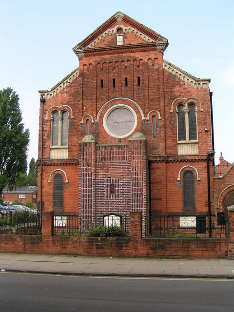
| Description | English: Sir Moses Montefiore Synagogue, Heneage Road, Grimsby, Lincolnshire, seen from the south. Also known as Grimsby Hebrew Congregation, the community was founded in 1742. The foundation stone was laid in July 1885 and the Synagogue officially opened on 11 December 1889. |
| Date | |
| Source | From geograph.org.uk |
| Author | John Readman |
| Attribution (required by the license) | John Readman / Grimsby Synagogue / |
| Camera location | | View this and other nearby images on: OpenStreetMap |
|---|
_&language=en)
Licensing

|
This image was taken from the Geograph project collection. See this photograph's page on the Geograph website for the photographer's contact details. The copyright on this image is owned by John Readman and is licensed for reuse under the Creative Commons Attribution-ShareAlike 2.0 license. |
This file is licensed under the Creative Commons Attribution-Share Alike 2.0 Generic license.
Attribution: John Readman
- You are free:
- to share – to copy, distribute and transmit the work
- to remix – to adapt the work
- Under the following conditions:
- attribution – You must give appropriate credit, provide a link to the license, and indicate if changes were made. You may do so in any reasonable manner, but not in any way that suggests the licensor endorses you or your use.
- share alike – If you remix, transform, or build upon the material, you must distribute your contributions under the same or compatible license as the original.
File history
Click on a date/time to view the file as it appeared at that time.
| Date/Time | Thumbnail | Dimensions | User | Comment | |
|---|---|---|---|---|---|
| current | 07:08, 31 January 2010 | | 480 × 640 (97 KB) | GeographBot | == {{int:filedesc}} == {{Information |description={{en|1=Grimsby Synagogue. The synagogue in Grimsby is situated in Heneage Road, which at one time was close to the centre of the busy fishing industry. Not far away was the fish docks and the corporation d |
File usage
The following 2 pages use this file:
Global file usage
The following other wikis use this file:
- Usage on fr.wikipedia.org
- Usage on www.wikidata.org