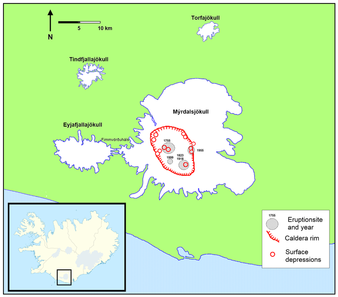
Fil:Location of Katlas caldera.png

Storlek på förhandsvisningen: 683 × 600 pixlar. Andra upplösningar: 273 × 240 pixlar | 547 × 480 pixlar | 875 × 768 pixlar | 1 166 × 1 024 pixlar | 1 769 × 1 553 pixlar.
Originalfil (1 769 × 1 553 pixlar, filstorlek: 229 kbyte, MIME-typ: image/png)
Filhistorik
Klicka på ett datum/klockslag för att se filen som den såg ut då.
| Datum/Tid | Miniatyrbild | Dimensioner | Användare | Kommentar | |
|---|---|---|---|---|---|
| nuvarande | 30 augusti 2010 kl. 21.33 |  | 1 769 × 1 553 (229 kbyte) | RicHard-59 | Added location of 1999 eruption based on image on [http://pics.livejournal.com/michaelbix/pic/0001db5b pics.livejournal.com] |
| 29 maj 2010 kl. 08.45 |  | 1 769 × 1 553 (228 kbyte) | RicHard-59 | The glaciers: more details; caldera rim more precise; eruption sites; surface depression-sites | |
| 27 april 2010 kl. 09.48 |  | 724 × 500 (69 kbyte) | RicHard-59 | {{Information |Description={{en|1=Partly enlarged section: shows the area of Mýrdalsjökull-glacier with estimated location of the caldera of Katla-volcano. Location is based on this [http://www.raunvis.hi.is/~mtg/pdf/Jokull49_HBetal_Myrdalsjokull.pdf st |
Filanvändning
Följande sida använder den här filen:
Global filanvändning
Följande andra wikier använder denna fil:
- Användande på bn.wikipedia.org
- Användande på cs.wikipedia.org
- Användande på de.wikipedia.org
- Användande på en.wikipedia.org
- Användande på es.wikipedia.org
- Användande på fi.wikipedia.org
- Användande på hy.wikipedia.org
- Användande på is.wikipedia.org
- Användande på ky.wikipedia.org
- Användande på mk.wikipedia.org
- Användande på pl.wikipedia.org
- Användande på ro.wikipedia.org
- Användande på sl.wikipedia.org

