Witteveen, Midden-Drenthe
Witteveen | |
|---|---|
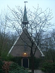
 Former chapel of Witteveen | |
| Coordinates: 52°48′51″N 6°39′36″E / 52.81417°N 6.66000°E | |
| Country | Netherlands |
| Province | Drenthe |
| Municipality | Midden-Drenthe |
| Established | 1926 |
| Area | |
• Total | 15.72 km2 (6.07 sq mi) |
| Elevation | 17 m (56 ft) |
| Population (2021)[1] | |
• Total | 555 |
| • Density | 35/km2 (91/sq mi) |
| Time zone | UTC+1 (CET) |
| • Summer (DST) | UTC+2 (CEST) |
| Postal code | 9439[1] |
| Dialing code | 0593 |
Witteveen (Dutch pronunciation: [ˈʋɪtəˌveːn]; English: White Bog) is a village in the Dutch province of Drenthe. It is a part of the municipality of Midden-Drenthe, and lies about 16 km northeast of Hoogeveen.
The village was first mentioned in 1856 as "het Witteveen", and means "white peat". In 1926, the peat was excavated as part of a project for the unemployed.[3] 50 houses were built to house the workers. In 1929, a small Dutch Reformed church was built.[4] The church is nowadays used as a residential home.[5]
Gallery
- Former clergy house
- Welcome to Witteveen
References
- ^ a b c "Kerncijfers wijken en buurten 2021". Central Bureau of Statistics. Retrieved 11 April 2022.
- ^ "Postcodetool for 9439PA". Actueel Hoogtebestand Nederland (in Dutch). Het Waterschapshuis. Retrieved 11 April 2022.
- ^ "Witteveen - (geografische naam)". Eymologiebank (in Dutch). Retrieved 11 April 2022.
- ^ Ronald Stenvert (2001). Witteveen (in Dutch). Zwolle: Waanders. p. 61. ISBN 90 400 9454 3. Retrieved 11 April 2022.
- ^ "Witteveen". Plaatsengids (in Dutch). Retrieved 11 April 2022.
External links
 Media related to Witteveen, Midden-Drenthe at Wikimedia Commons


