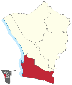
Walvis Bay Rural

Walvis Bay Rural constituency is a constituency in the Erongo Region of Namibia. It comprises the rural area surrounding the constituency's district capital city of Walvis Bay, and additionally some streets on the outskirts of the city.[1] It had a population of 26,916 in 2011, up from 16,293 in 2001. Walvis Bay Rural covers 9,150 km2 (3,530 sq mi) of land.[2] As of 2020 the constituency had 25,746 registered voters.[3]
Walvis Bay Rural was created in 1998. Following a recommendation of the Second Delimitation Commission of Namibia, and in preparation of the 1998 general election, the old Walvis Bay Constituency was split into Walvis Bay Urban and Walvis Bay Rural.[4]
Inhabitants
Walvis Bay Rural constituency includes a string of settlements by the ǂAonin (Southern Topnaar) community, a subtribe of the Nama people. These settlements are situated along the Kuiseb River and include Utuseb and Rooibank.[5]
Politics
Walvis Bay Rural is traditionally a stronghold of the South West Africa People's Organization (SWAPO) party. In the 2004 regional election SWAPO politician Johannes Nangolo received 4,426 of the 5,300 votes cast and became councillor.[6] Councillor Nangolo (SWAPO) was re-elected in the 2010 regional elections with 3,804 votes. His closest challenger was Tjitekuru Joseph of the Rally for Democracy and Progress, who received 646 votes.[7] Nangolo also won the 2015 regional elections with 3,928 votes. Runner-up and only challenger was Joan Valencia Izaaks of the Democratic Turnhalle Alliance (DTA) who received 801 votes.[8][9]
The 2020 regional election was won by Florian Tegako Donatus of the Independent Patriots for Change (IPC, an opposition party formed in August 2020). He obtained 3,433 votes. The SWAPO candidate, Hilma Tonata Shikongo, came second with 2,318 votes, and Ambrosius Swartbooi of the Landless People's Movement (LPM, an opposition party formed in 2016) came in third with 904 votes.[3]
References
- ^ de Klerk, Eveline (14 September 2020). "Constituency boundaries questioned". New Era. p. 1.
- ^ "Chapter 2: Population Structure, Composition and Density" (PDF). 2011 Population and Housing Census - Erongo Regional Profile. Namibia Statistics Agency. p. 4. Retrieved 4 November 2024.
- ^ a b "Regional Council 2020 Election Results". Interactive map. Electoral Commission of Namibia. 18 January 2021. Retrieved 17 March 2021.
- ^ "Re-division of certain regions into constituencies: Regional Councils Act, 1992" (pdf). Government Gazette of the Republic of Namibia. No. 1940. Government of Namibia. 31 August 1998. p. 21.
- ^ de Klerk, Eveline (25 January 2013). "Rural community wants police station". New Era.
- ^ "Electoral Act, 1992: Notification of Result of General Election for Regional Councils" (pdf). Government Gazette of the Republic of Namibia. No. 3366. Government of Namibia. 3 January 2005. p. 12.
- ^ Election results from Electoral Commission of Namibia
- ^ "Regional elections 2015". The Namibian. Regional Elections supplement. 1 December 2015. p. D2.
- ^ "Regional Council Election Results 2015". Electoral Commission of Namibia. 3 December 2015. p. 3.
