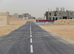
Umm Qarn
Umm Qarn أم قرن | |
|---|---|
Village | |
 Residential area in Umm Qarn | |
| Coordinates: 25°34′40″N 51°27′0″E / 25.57778°N 51.45000°E | |
| Country | |
| Municipality | Al Daayen |
| Zone | Zone 70 |
| District no. | 126 |
| Area | |
• Total | 11.4 km2 (4.4 sq mi) |

Umm Qarn (Arabic: أم قرن) is a Qatari village in the municipality of Al Daayen.[2] Located just off Al Shamal Highway, the village hosts the municipal office and currently serves as the municipality's administrative seat.[3]
The settlement derives its name from local geographical features. Umm Qarn translates to 'mother of flat shaped hill'.[4]
History
In July 1985, the government announced it had begun a campaign to distribute fresh water to rural villages in Qatar suffering from water shortages. As part of this campaign, QAR 25,000 was allocated towards water distribution in Umm Qarn.[5]
Geography
Umm Qarn is situated in eastern Qatar, about 35 km from the capital Doha.[6] It is located in the northern part of the Al Daayen Municipality. The villages of Abu Thaylah and Simaisma are nearby.[7]
It forms the southernmost boundary of the southern sector of Qatar's interior plain region. The area around Umm Qarn, as part of this southern sector, is characterized by small hills and valleys. Rawdas (depressions) are also a common feature. Elevations in the area range from 3 metres (9.8 ft) to 45 metres (148 ft).[8]
Landmarks
An 580-acre stud farm, Umm Qarn Stud Farm, is found in the village. It is a luxury stable which houses dozens of champion horses. Most food requirements are imported from abroad except during winter when grass seed originating from the US is planted.[9]
Developments
The Qatar National Master Plan (QNMP) is described as a "spatial representation of the Qatar National Vision 2030".[10] As part of the QNMP's Urban Centre plan, which aims to implement development strategies in 28 central hubs that will serve their surrounding communities, Umm Qarn has been designated a Town Centre, which is the third-highest designation.[11]
Al Daayen Municipality is developing Umm Qarn as a retail and administrative center for the municipality's northern settlements, such as Simaisma. Currently, the village already has a municipal office, the municipality's only primary healthcare center, a civil defense center, a police station and two primary schools. Officials have discussed the future possibility of constructing a metro station in the village.[3] About four-fifths of the village's overall area stands vacant. New projects have been taking place to the north-east of the current village nucleus, particularly a public school and a new governments services complex. Municipal officials are planning to create new office and retail spaces near the government services complex. The government services complex will be 74,744 m2 and contain emergency and police services, a mosque and a primary health care centre. A 41,267 m2 social centre is also in the works.[12]
Agriculture
The Arab Qatari Company for Poultry Production was founded in 1984 with its main poultry farm being in Umm Qarn.[13] In 1985, the year after its establishment, the government announced it would be implementing a project to increase the production of meat chickens to 4 million and eggs to 45 million on annual basis.[14]
Annually, over 300,000 seedlings are grown in Umm Qarn's nursery. Most of these seedlings are distributed to Qatar's various government ministries. The nursery covers an area of about 20 hectares and has 7 growing areas.[6] A tree nursery in nearby Rawdat Bakheela in Al Khor Municipality was rehabilitated in 2008, and is used by the government for research and tree production.[15]
Education
The following schools are located in Umm Qarn:
| Name of School | Curriculum | Grade | Genders | Ref |
|---|---|---|---|---|
| Az Zaanen Primary and Secondary School | Independent | Primary/Secondary | Female-only | [16] |
| Sumaismah Primary School | Independent | Primary | Male-only |
External links
Umm Qarn: Qatar, Geographic.org
References
- ^ "District Area Map". Ministry of Development Planning and Statistics. Retrieved 12 March 2019.
- ^ "2010 population census" (PDF). Qatar Statistics Authority. Retrieved 29 June 2015.
- ^ a b "Al Daayen Municipality: Vision and Development Strategy" (PDF). Ministry of Municipality and Environment. December 2017. p. 15. Retrieved 22 May 2018.
- ^ Jacques LeBlanc (March 2008). "A fossil hunting guide to the tertiary formations of Qatar, Middle East".
- ^ "توصيل المياه العذبة لقرى منطقة الشمال" (in Arabic). Al Raya. 4 July 1985. Retrieved 10 June 2024.
- ^ a b "تطوير روضة بخيلة ينقذها من الإهمال والاندثار" (in Arabic). Al Sharq. 13 February 2013. Retrieved 8 August 2017 – via PressReader.
- ^ "Qatar Socio-Economic Atlas". Ministry of Development Planning and Statistics. Retrieved 8 August 2017.
- ^ "طبوغرافية شبه جزيرة قطر" (in Arabic). Qatar Historical Encyclopedia. 28 April 2024. Retrieved 20 July 2024.
- ^ Sheena McKenzie (1 March 2013). "Qatar's six-star hotel ... for horses". CNN. Retrieved 25 November 2019.
- ^ "About Qatar National Master Plan". Ministry of Municipality and Environment. Retrieved 11 November 2019.
- ^ "About the Centre Plans". Ministry of Municipality and Environment. Retrieved 11 November 2019.
- ^ "Centre Plans and Zoning Regulations" (PDF). Ministry of Municipality and Environment. pp. 183–189. Retrieved 11 November 2019.
- ^ "Arab multinational enterprises : an analytical compendium" (PDF). United Nations Conference on Trade and Development. 29 March 1993. p. 50. Retrieved 10 June 2024.
- ^ "توسعة المخزون الغذائى الاستراتيجي للبلاد . مشروع كبير لانتاج الالبان والبيض واللحوم وبنك للمعلومات الاحصائية" (in Arabic). Al Raya. 7 March 1985. Retrieved 10 June 2024.
- ^ "تدشين أسبوع الشجرة بروضة بخيلة اليوم" (in Arabic). Al Raya. 2 March 2008. Retrieved 8 August 2017.
- ^ "Qatari Schools". Supreme Education Council. Archived from the original on 24 September 2015. Retrieved 18 July 2015.

