Strada statale 35 dei Giovi
| State Highway 35 | ||||
|---|---|---|---|---|
| Strada statale 35 | ||||
| Giovi | ||||
 | ||||
| Route information | ||||
| Maintained by ANAS | ||||
| Length | 172.8 km (107.4 mi) | |||
| Existed | 1928–present | |||
| Major junctions | ||||
| From | Genoa | |||
| A4 at Cormano A52 at Paderno Dugnano | ||||
| To | Como | |||
| Location | ||||
| Country | Italy | |||
| Regions | Liguria, Piedmont, Lombardy | |||
| Highway system | ||||
| ||||
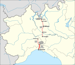
Strada statale 35 dei Giovi is an Italian state highway 172.8 kilometres (107.4 mi) long in Italy located in the regions of Liguria, Piedmont and Lombardy, which connects Genoa and the Italian Riviera with Como and the Canton of Ticino, passing through Pavia and Milan. The road begins in Genoa in the Sampierdarena district where it constitutes an important urban crossing artery with the Reti and Fillak streets, and then ends in Como more precisely at the Customs House in Ponte Chiasso on the border with Switzerland. Between Tortona and Casteggio the SS 35 is in common with the strada statale 10, while the Milan-Cermenate section is a Superstrada, built around the 1960s known as Superstrada Milano-Meda.
History
Strada statale 35 dei Giovi was established in 1928 with the following route: "From Genoa to Ronco Scrivia - Serravalle to Tortona, with a branch from Serravalle to Spinetta Marengo near Alessandria and from Casteggio to Pavia - Milan - Asnago - Como on the Swiss border towards Chiasso".[1]
Following the legislative decree n. 112 of 1998, in 2001, the management passed from ANAS to the regional governments of Liguria, Piedmont and Lombardy Region, which have further devolved the competences to their respective provinces, as there is no regional road classification in these regions.
In 2018, the Ligurian section of the road was once again included in the road network of national interest, thus restoring its classification as a state road.[2][3] In 2021, the same happened to the Piemontese section and a little section in Lombardy.[3]
In the Milanese area, the road follows two historic arteries: in the northern section, in fact, the road already existed in the Middle Ages as the backbone of the communications of the Duchy of Milan, where it was known as the Dergano road, which in modern times became the Comasina.[4][5]
Route


dei Giovi | ||||
| Exit | ↓km↓ | Province | ||
|---|---|---|---|---|
| 127.0 km (78.9 mi) |
MI | |||
| 127.5 km (79.2 mi) |
MI | |||
| 128.5 km (79.8 mi) |
MI | |||
| 130.5 km (81.1 mi) |
MI | |||
| 131.5 km (81.7 mi) |
MI | |||
| 132.5 km (82.3 mi) |
MI | |||
| 133.5 km (83.0 mi) |
MI | |||
| 134.5 km (83.6 mi) |
MI | |||
| 135.0 km (83.9 mi) |
MI | |||
| 136.5 km (84.8 mi) |
MB | |||
| 138.5 km (86.1 mi) |
MB | |||
| 139.5 km (86.7 mi) |
MB | |||
| 140.0 km (87.0 mi) |
MB | |||
| 141.0 km (87.6 mi) |
MB | |||
| 143.0 km (88.9 mi) |
MB | |||
| 145.0 km (90.1 mi) |
MB | |||
| 145.5 km (90.4 mi) |
MB | |||
| 149.0 km (92.6 mi) |
MB | |||
| 150.5 km (93.5 mi) |
MB | |||
| 150.6 km (93.6 mi) |
CO | |||
References
- ^ Legge 17 maggio 1928, n. 1094
- ^ Decreto del Presidente del Consiglio dei ministri della Repubblica Italiana 20 febbraio 2018 in materia di "Revisione delle reti stradali di interesse nazionale e regionale ricadenti nelle Regioni Abruzzo, Basilicata, Calabria, Campania, Lazio, Liguria, Marche, Molise, Puglia, Toscana e Umbria."
- ^ a b "Rientro strade".
- ^ La strada di Dergano
- ^ La Comasina
See also
Other Italian roads
External links
![]() Media related to Strada statale 35 dei Giovi at Wikimedia Commons
Media related to Strada statale 35 dei Giovi at Wikimedia Commons

