Stora Drammen
58°56′N 10°58′E / 58.933°N 10.967°E


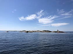
Stora Drammen is an uninhabited skerry situated northwest of the Bohuslän province of Götaland, Sweden. It is administratively part of Strömstad Municipality and represents the westernmost extreme point of Sweden.[1][2]
Geography
Stora Drammen is located within the Skagerrak Strait about 10 km from the nearest mainland city of Strömstad. It is also 2 km northwest from Nordkoster of the Koster Islands archipelago within the Kosterhavet National Park.[1][2] The skerry is part of the Tjärnö district of Strömstad municipality in Västra Götaland County. Stensvik is mainland Sweden's westernmost point and located about 15 km northeast of Stora Drammen.
A sea cairn is present on the skerry to mark the Sweden-Norway border, with the border with Norway's Østfold region running only a few hundred meters north of it.[3]
History
From the early 19th century, the Grisbådarna area within the Skagerrak Strait was subjected to a maritime territorial dispute between Sweden and Norway. The Permanent Court of Arbitration in The Hague established the border on October 23, 1909 and awarded Grisbådarna to Sweden.[4]
References
- ^ a b "Statistical Yearbook of Sweden 2010" (PDF). SCB. Retrieved 1 December 2020.
- ^ a b Bada, Ferdinand (12 July 2018). "The Most Extreme Points of Sweden". World Atlas. Retrieved 1 December 2020.
- ^ "Strömstad Kosterhavet". Swedish National Heritage Board. Retrieved 1 December 2020.
- ^ "Maritime Boundary Norway-Sweden (Grisbådarna)". The Hague. Retrieved 1 December 2020.
