Mouri Syedan: Difference between revisions
Content deleted Content added
added reference |
rm wordsimilarity.com: not a source, add infobox, c/e |
||
| Line 1: | Line 1: | ||
{{Infobox settlement |
|||
[[File:MOuri.jpg|thumb|Mouri Syedan]] |
|||
| name = |
|||
| ⚫ | '''Mouri Syedan''' is located on Lehtrar Road in [[Rawalpindi District]] of [[Punjab, Pakistan|Punjab]] |
||
| official_name = |
|||
| native_name ={{Nastaliq|}} |
|||
| native_name_lang = ur |
|||
| settlement_type = |
|||
| image_skyline = MOuri.jpg |
|||
| imagesize = |
|||
| image_alt = |
|||
| image_caption = |
|||
| ⚫ | |||
| pushpin_map = Pakistan Punjab#Pakistan |
|||
| pushpin_label_position = <!-- left, right, top, bottom, none --> |
|||
| pushpin_map_alt = |
|||
| pushpin_mapsize = |
|||
| pushpin_map_caption = |
|||
| subdivision_type = [[Country]] |
|||
| subdivision_name = [[Pakistan]] |
|||
| subdivision_type1 = [[Administrative units of Pakistan|Province]] |
|||
| subdivision_name1 = [[Punjab, Pakistan|Punjab]] |
|||
| subdivision_type2 = [[Districts of Pakistan|District]] |
|||
| subdivision_name2 = [[Rawalpindi District|Rawalpindi]] |
|||
| area_total_km2 = |
|||
| population_as_of = |
|||
| population_total = |
|||
| population_density_km2 = |
|||
| timezone1 = [[Time in Pakistan|PST]] |
|||
| utc_offset1 = +5 |
|||
<!-- Area/postal codes & others --------> |
|||
|postal_code = |
|||
|postal_code_type = [[Postal codes in Pakistan|Postal code]] |
|||
|area_code_type = [[Dialling codes in Pakistan|Dialling code]] |
|||
|area_code = |
|||
}} |
|||
| ⚫ | '''Mouri Syedan''' is located on Lehtrar Road in [[Rawalpindi District]] of [[Punjab, Pakistan|Punjab]], Pakistan.<ref>{{cite web |title=Mouri Syedan on Maps |url=https://www.google.com/maps/place/Mouri+Syedan/@33.6613898,73.3613793,17z/data=!3m1!4b1!4m5!3m4!1s0x38dfe6c94769798f:0xcf18ba159a95939f!8m2!3d33.6613898!4d73.363568 |website=[[Google Maps]] |accessdate=15 August 2018}}</ref> It is situated at an elevation of {{convert|2297|ft}}.<ref>{{cite web |title=Elevation of Mouri Syedan |url=https://mapcarta.com/26511464 |website=Mapcarta.com |accessdate=15 August 2018}}</ref> Mouri Syedan is famous for its turns, forests and streams. It is about {{convert|45|km}} away from [[Islamabad]].<ref>{{cite web |title=Distance from Islamabad |url=https://www.google.com/maps/dir/Islamabad,+Islamabad+Capital+Territory/Mouri+Syedan,+Lehtrar+Rd,+Chirah,+Islamabad,+Rawalpindi,+Punjab+45680/data=!4m8!4m7!1m2!1m1!1s0x38dfbfd07891722f:0x6059515c3bdb02b6!1m2!1m1!1s0x38dfe6c94769798f:0xcf18ba159a95939f!3e0 |website=[[Google Maps]] |accessdate=15 August 2018}}</ref> |
||
The main language spoken is [[Pahari-Pothwari]]. |
|||
== Languages == |
|||
Major languages spoken in Mouri Syedan are [[Pothohari language|Pothohari]] and [[Pahari language|Pahar]].<ref>{{cite web |title=Languages Spoken in Mouri Syedan |url=https://wordsimilarity.com/en/syedan |website=wordsimilarity.com |accessdate=15 August 2018}}</ref> |
|||
== See also == |
== See also == |
||
| Line 14: | Line 46: | ||
[[Category:Tourist attractions in Punjab, Pakistan]] |
[[Category:Tourist attractions in Punjab, Pakistan]] |
||
| ⚫ | |||
{{Rawalpindi-geo-stub}} |
{{Rawalpindi-geo-stub}} |
||
Latest revision as of 20:08, 9 December 2019
Mouri Syedan | |
|---|---|
 | |
| Coordinates: 33°39′41″N 73°21′49″E / 33.661425°N 73.363547°E | |
| Country | Pakistan |
| Province | Punjab |
| District | Rawalpindi |
| Time zone | UTC+5 (PST) |
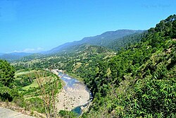
Mouri Syedan is located on Lehtrar Road in Rawalpindi District of Punjab, Pakistan.[1] It is situated at an elevation of 2,297 feet (700 m).[2] Mouri Syedan is famous for its turns, forests and streams. It is about 45 kilometres (28 mi) away from Islamabad.[3]
The main language spoken is Pahari-Pothwari.
See also
References
- ^ "Mouri Syedan on Maps". Google Maps. Retrieved 15 August 2018.
- ^ "Elevation of Mouri Syedan". Mapcarta.com. Retrieved 15 August 2018.
- ^ "Distance from Islamabad". Google Maps. Retrieved 15 August 2018.


