
Talk:Banovina of Croatia: Difference between revisions
Future Perfect at Sunrise (talk | contribs) →RfC: Shouldn't this Banovinas_in_BiH.GIF map be included in article?: restructuring, explanative links; hiding inappropriate fighting |
|||
| Line 33: | Line 33: | ||
North of kotar Bugojno was kotar Jajce wich included today's municipalities of Jajce,Jezero,Šipovo and Dobretići and which was part of Vrbas Banovina.<br> Laz, are you really just stalling or you can not go to the city library and take a look ina any of the school atlases from time of second Yugoslavia? In them you'll clearly see that Donji Vakuf '''was part''' of Banovina Croatia. --[[User:Ceha|Čeha]] <small>([[User talk:Ceha|razgovor]])</small> 23:57, 26 November 2009 (UTC) |
North of kotar Bugojno was kotar Jajce wich included today's municipalities of Jajce,Jezero,Šipovo and Dobretići and which was part of Vrbas Banovina.<br> Laz, are you really just stalling or you can not go to the city library and take a look ina any of the school atlases from time of second Yugoslavia? In them you'll clearly see that Donji Vakuf '''was part''' of Banovina Croatia. --[[User:Ceha|Čeha]] <small>([[User talk:Ceha|razgovor]])</small> 23:57, 26 November 2009 (UTC) |
||
==RfC: |
==RfC: Should [[:File:Banovinas_in_BiH.GIF]] map be included in article?== |
||
{{rfctag|hist}} |
{{rfctag|hist}} |
||
[[File:Banovinas_in_BiH.GIF|thumb|right|Proposed map, by [[User:Ceha]]]] |
|||
*[[:File:Banovinas_in_BiH.GIF]], proposed new map by [[User:Ceha]] |
|||
*[[:File:Map of Banovina of Croatia.jpg]], previously used non-free map (will soon be deleted for copyright reasons) |
|||
It is a more detailed map of the part of the Banovina area. [[User:Ceha|Čeha]] <small>([[User talk:Ceha|razgovor]])</small> 16:00, 26 November 2009 (UTC) |
It is a more detailed map of the part of the Banovina area. [[User:Ceha|Čeha]] <small>([[User talk:Ceha|razgovor]])</small> 16:00, 26 November 2009 (UTC) |
||
:There is no source for the precision that Ceha has claimed in the map. ([[User:LAz17|LAz17]] ([[User talk:LAz17|talk]]) 17:53, 26 November 2009 (UTC)). |
:There is no source for the precision that Ceha has claimed in the map. ([[User:LAz17|LAz17]] ([[User talk:LAz17|talk]]) 17:53, 26 November 2009 (UTC)). |
||
::This is an article about Banovina of Croatia. Present day map of Bosnia and Hercegovina with some color shades which should represent parts of Banovina in todays Bosnia is perhaps for the article about the history of Bosnia, or something.--[[User:Ex13|Ex13]] ([[User talk:Ex13|talk]]) 19:41, 26 November 2009 (UTC) |
::This is an article about Banovina of Croatia. Present day map of Bosnia and Hercegovina with some color shades which should represent parts of Banovina in todays Bosnia is perhaps for the article about the history of Bosnia, or something.--[[User:Ex13|Ex13]] ([[User talk:Ex13|talk]]) 19:41, 26 November 2009 (UTC) |
||
| Line 41: | Line 46: | ||
::Laz, upper maps are sources, and also; [http://manjgura.hr/wp-content/uploads/2009/04/kraljevina-jugoslavija-sa-podjelom-na-banovine-1929-god.jpg] [http://cro-eu.com/galerija-fotografija/albums/userpics/10001/9-Kraljevina_Jugoslavija_-_podjela_na_banovine_1931.jpg] [http://media.photobucket.com/image/banovina%20hrvatska/ignotus1/scan0001.jpg] [http://media.photobucket.com/image/banovina%20hrvatska/niko1957/1939b-1000.jpg] [http://img132.imageshack.us/img132/360/banovinahrvatskarl6.jpg], borders of Banovina followed borders of kotars. You can find full list of kotars here [http://hr.wikipedia.org/wiki/Banovina_Hrvatska]. --[[User:Ceha|Čeha]] <small>([[User talk:Ceha|razgovor]])</small> 00:20, 27 November 2009 (UTC) |
::Laz, upper maps are sources, and also; [http://manjgura.hr/wp-content/uploads/2009/04/kraljevina-jugoslavija-sa-podjelom-na-banovine-1929-god.jpg] [http://cro-eu.com/galerija-fotografija/albums/userpics/10001/9-Kraljevina_Jugoslavija_-_podjela_na_banovine_1931.jpg] [http://media.photobucket.com/image/banovina%20hrvatska/ignotus1/scan0001.jpg] [http://media.photobucket.com/image/banovina%20hrvatska/niko1957/1939b-1000.jpg] [http://img132.imageshack.us/img132/360/banovinahrvatskarl6.jpg], borders of Banovina followed borders of kotars. You can find full list of kotars here [http://hr.wikipedia.org/wiki/Banovina_Hrvatska]. --[[User:Ceha|Čeha]] <small>([[User talk:Ceha|razgovor]])</small> 00:20, 27 November 2009 (UTC) |
||
:::None of your maps there have donji vakuf included. On top of that, some of them contradict one another. We are dealing with the banovina of croatia, not the other banovinas... and as we can see, the other banovina links contradict one another. Please stop wasting our time. ([[User:LAz17|LAz17]] ([[User talk:LAz17|talk]]) 01:23, 27 November 2009 (UTC)). |
:::None of your maps there have donji vakuf included. On top of that, some of them contradict one another. We are dealing with the banovina of croatia, not the other banovinas... and as we can see, the other banovina links contradict one another. Please stop wasting our time. ([[User:LAz17|LAz17]] ([[User talk:LAz17|talk]]) 01:23, 27 November 2009 (UTC)). |
||
{{collapse top|Feuding editors sniping at each other}} |
|||
::::Laz, you are wasting my time as it is obvious that you do not know nothing about banovinas. I told you before, go to the library, check elementary public school atlas from ex-yugoslavia and you'll see that Donji Vakuf is involved. If you do not do that, than you are stalling the discussion and intentionally troling. |
::::Laz, you are wasting my time as it is obvious that you do not know nothing about banovinas. I told you before, go to the library, check elementary public school atlas from ex-yugoslavia and you'll see that Donji Vakuf is involved. If you do not do that, than you are stalling the discussion and intentionally troling. |
||
::::Second, I'm not sure if you are aware off, but if a country is divided into administrative units as it is with the banovinas in this case, then every town must be in one of the banovinas. Donji Vakuf was in Bugojno kotar in Primorska (Littoral) banovina before it was made part of Banovina Croatia. Only other banovina wich is north of it is Banovina Vrbas, wich it's kotar of Jajce. In 1939 Donji Vakuf was not made a seperate kotar, nor was annexed to the kotar of Jajce. That is a second proof that Donji Vakuf was part of Banovina Croatia. |
::::Second, I'm not sure if you are aware off, but if a country is divided into administrative units as it is with the banovinas in this case, then every town must be in one of the banovinas. Donji Vakuf was in Bugojno kotar in Primorska (Littoral) banovina before it was made part of Banovina Croatia. Only other banovina wich is north of it is Banovina Vrbas, wich it's kotar of Jajce. In 1939 Donji Vakuf was not made a seperate kotar, nor was annexed to the kotar of Jajce. That is a second proof that Donji Vakuf was part of Banovina Croatia. |
||
| Line 55: | Line 61: | ||
:Source 2 - http://i459.photobucket.com/albums/qq314/LAzWikiDude/DonjiVakufSitJedi.gif |
:Source 2 - http://i459.photobucket.com/albums/qq314/LAzWikiDude/DonjiVakufSitJedi.gif |
||
:In your maps you do not even see donji vakuf labeled. So, buzz off and stop wasting my time until you have something concrete to contribute. ([[User:LAz17|LAz17]] ([[User talk:LAz17|talk]]) 17:44, 28 November 2009 (UTC)). |
:In your maps you do not even see donji vakuf labeled. So, buzz off and stop wasting my time until you have something concrete to contribute. ([[User:LAz17|LAz17]] ([[User talk:LAz17|talk]]) 17:44, 28 November 2009 (UTC)). |
||
{{collapse bottom}} |
|||
Revision as of 20:08, 28 November 2009
| Yugoslavia Start‑class High‑importance | ||||||||||
| ||||||||||

| Croatia Start‑class High‑importance | ||||||||||
| ||||||||||
| Bosnia and Herzegovina Start‑class High‑importance | ||||||||||
| ||||||||||

Here we go again...
- I will not stand for your NDH legitimacy pushing. Take a gander at the Kingdom of Yugoslavia article. It is packed full of sources about that state, sources which have led to the User consensus on representing it as lasting either up to 1943, or even up to 1945. If you believe that the Banovina of Croatia, an administrative subdivision of the Kingdom of Yugoslavia, somehow ceased to exist before the Kingdom of Yugoslavia itself, you are talking nonsense. Nonsense again motivated by your consistent POV-pushing in the direction of "legitimizing" the fascist Independent State of Croatia (NDH), by diminishing the representation of the legal Croatian WWII entities in every conceivable way.
- Was the Banovina of Croatia succeeded by the NDH when it "ceased to exist" in 1941? Hmmm?? I wonder if you'll answer that... because writing up DFY or FS Croatia as the successors in 1941 is an utter travesty (and you know it).
- I am supremely indifferent as to whether or not you consider the word "puppet" to be unnecessary by your own opinion. It is correct, it is sourced, and removing it is clear POV-vandalism aimed at destroying factual accuracy by not mentioning crucial facts about a mentioned state's status. If I wish to add more detail to this article, you have absolutely no right to remove it because you don't like it personally.
- It may be incorrect to write up the FS Croatia as the successor, and you may have a point there... While both have arguments, I've been considering switching the 1943 successor state to DF Yugoslavia myself. If you object to the current successor, this alteration is fine. --DIREKTOR (TALK) 22:01, 9 July 2009 (UTC)
Discuss issues and not your believes
- (1) You are pushing POV as if the ISC never existed, you even tryed to remove it from the Template:History of Croatia. Its existence cannot be removed. It cannot be removed because you and me both would regard it obsolete and harmful towards Croatia, or because it was or wasn’t a state, but because it existed and history do not judge states, nations, etc. but regimes and individuals.
- (2) you and simmilar POVers continue your rude attempt to include in almost every article where the ISC is mentioned the phrase "puppet" (natturaly with a sentence or two about its creation, and such sentences). This is simply wrong, Banovina of Croatia has nothing to do with the ISC. Its history cannot be "tainted" with any description of what happened latter. We have the ISC article for that.
- (3) By using POV like ISC was not independent, a state, or Croatian is diminishing the responsability of that state in every conceivable way. The ISC had been a state created after the torture and the dictatorship of the Kingdom of Yugoslavia, it was created with the help of the Axis, it was legaly created since Italy and Bulgaria were not States Parties of the Hague Conventions (and the Kingdom of Albania under the House of Savoy also) + there were no international law on how states gain independence or statehood, even today that chapter of international law is being written (Kosovo). It is a completely different story the regime (Ustashi) or the legal system (dictatorship with limited assembly — written with small caps)
- (4) Banovina of Croatia as an administrative and federal unit ceased to exist in 1941, this can be proven by reading some of notable historians (all of them are not belevolent towards the ISC), Croatian Peasent Party members that went with the Royal Govt in Exile tryed to protect the Cvetković-Maček Agreement for the re-creation of the Banovina of Croatia after the war — but without no assurances for that re-creation.
- (5) No concensus (you have not even provided a precise link) is for all times'. Your POV is clear to us all, you defend the theory of the Kingdom of Yugoslavia existing on paper but fail to provide on what basis did the Allies recognize the Royal Govt in Exile. Before Teheran the Soviet had not recognized the Royal Govt in Exile but only the Partisans. After that (in Nov 1943) a compromise was made and the other two major Allied Powers (US and UK) recognized Partisans while the USSR recognized a 50/50 policy on the after war influence over Yugoslavia. At that point in time the Allied decided to re-create Yugoslavia after the war as a equall joint venture partnership and not the Kingdom of Yugoslavia under the Karageorgevitch.
- (6) Banovina of Croatia was an administrative unit that outgrew into a federal unit in the new-deal of Cvetković-Maček. I do not consider the Banovina as a precedent for the ISC nor the precedent for the FSC. The FSC was before the 1946-01-31 Constitution of FPRY a state which would became a member of the Yugoslav federation, but was in that time virtually independent from Belgrade (due to poor phone, rail, etc. connections between Šibenik early 1945, and latter Split based headquoters).
- (7) It is POV and vandalism to insist on writing defamations in the article that is not connected with the history of the ISC. Like the article on Croatian decorations where some biased and "narrow-banded" users the POV of your choice "puppet, fascist, created by, etc." to push POV and spread propaganda in an article that has no real connection with the issue.
- (8) The Democratic Federal Yugoslavia could have been constituted when AVNOJ declared itself as a Temporary National Assembly in 1945. Why? Because the federal states had to be constituted before the federation could had been constituted. E.g. When all the federal states were proclaimed by their own Antifascist Council, then the DFY have been proclaimed.
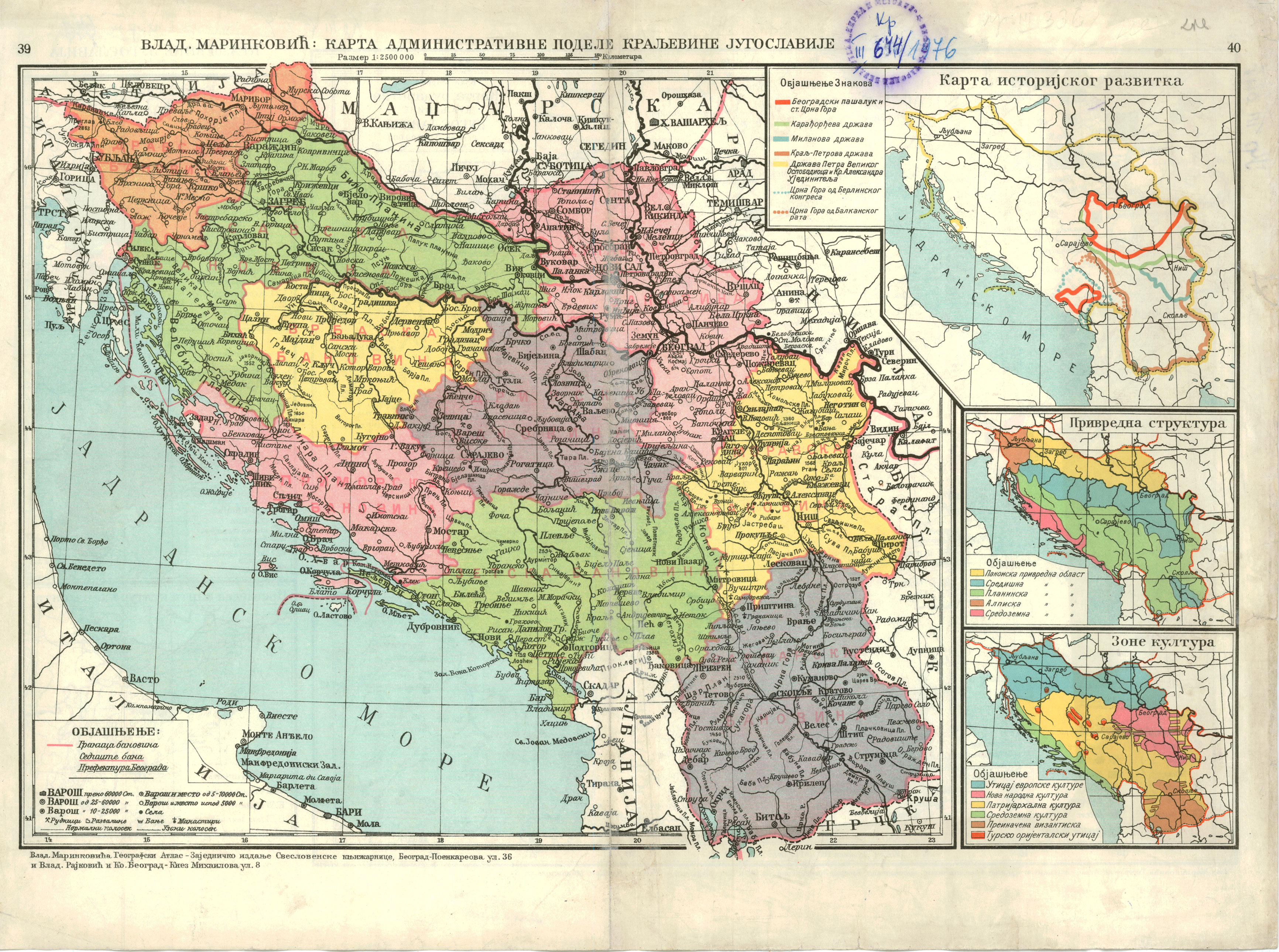
Banovina map
Today's town and municipality of Donji Vakuf was in 1939 in kotar of Bugojno which that year became part of Banovina Hrvatska. Before that kotar Bugojno was part of Primorska banovina. Whole of Primorska banovina 1939 became part of Ban. Hrvatska. Laz do you have some source which would claim otherways? --Čeha (razgovor) 08:09, 25 November 2009 (UTC)
- Look at this map, http://terkepek.adatbank.transindex.ro/kepek/netre/178.gif . It appears that there is much more land from Jajce to the border. The border on your map is much closer to jajce. (LAz17 (talk) 17:04, 25 November 2009 (UTC)).
- Bigger maps have smaller precision. Look at the positions of the Zenica and Travnik in yours map. They are to close. Livno is a bit eastern that it's true position, and Konjic, Travnik and Fojnica northern. Municipal map is more precise. If Donji Vakuf had been part of Vrbas banovina, than also half of todays municipality of Travnik would have been in Vrbas banovina, as well as half of Zenica and almost whole of Žepče. Don't you have a old Yougoslav geography atlas at home to check this? There the line is pretty much obvious showing that Donji Vakuf was in Banovina Croatia. --Čeha (razgovor) 20:07, 25 November 2009 (UTC)
- Also this [1] is full of errors. Do you see "bansogok hatural" (banate borders) 1931 in Syrmia in the map? That is not correct. That is a line from 1929. The same goes from line near Stolac. Stolac was part of Zetska banovina (1929-1931), but after 1931 is part of Littoral (Primorska) banovina. [2] [3], try to check Donji Vakuf location in those to maps. It is in Littoral (primorska) banovina whole the time. --Čeha (razgovor) 20:13, 25 November 2009 (UTC)
- Until we have a good detailed map we can not use this. Sorry. This map, http://upload.wikimedia.org/wikipedia/en/6/62/Map_of_Banovina_of_Croatia.jpg , is good enough anyways. It shows things nicely. I must admit that I really like it. At any rate, the border clearly goes along a kupres-bugojno-travnik line, barely going away from those towns. As we see, Jajce has more land around it, on the Serb side of the border there. Just use that map, it is good enough. No need to beat a dead horse, as the saying goes. (LAz17 (talk) 21:37, 25 November 2009 (UTC)).
- Laz, that is an nationalistic POV. Straith line goes through Travnik-Donji Vakuf-Kupres which is obvious on my map. I've given you two maps on wich that is clearly visible. If Donji Vakuf were not part of Banovina than there would be hole in that line. Also, let me repeat again, bigger map show things with less precission. Example: On your map Travnik is situated near the banovina line. Kotar travnik in 1939 included todays municipalities of Travnik, Novi Travnik, Vitez and most of Busovača. Whole of kotar was made part of the Banovina Hrvatska Banovina je nastala spajanjem dotadašnje Savske i Primorske banovine, uz dodatak većinski hrvatskih kotareva iz ostalih banovina (Brčko, Derventa, Dubrovnik, Fojnica, Gradačac, Ilok, Šid i Travnik ). Obuhvaćala je površinu od 65.456 km2. [4] and the exact location of town of Travnik can be seen on my map. Now if you do not have some proof showing otherways, please return the map. --Čeha (razgovor) 10:59, 26 November 2009 (UTC)
- Until we have a good detailed map we can not use this. Sorry. This map, http://upload.wikimedia.org/wikipedia/en/6/62/Map_of_Banovina_of_Croatia.jpg , is good enough anyways. It shows things nicely. I must admit that I really like it. At any rate, the border clearly goes along a kupres-bugojno-travnik line, barely going away from those towns. As we see, Jajce has more land around it, on the Serb side of the border there. Just use that map, it is good enough. No need to beat a dead horse, as the saying goes. (LAz17 (talk) 21:37, 25 November 2009 (UTC)).
- The line is not direct, and it encompasses donji vakuf which was not part of the croatian banovina. Simple as that. The area had almost no croats before and after the war. You can not claim that you have the accuracy to produce such a controversial map. At any rate, the maps on here already are good enough. (LAz17 (talk) 17:56, 26 November 2009 (UTC)).
- How the line is not direct? Does it goes 20 kilometers inward and than outward? How does it ethnic percentage of Donji Vakuf area has anything to do with border of Banovina? In southern Kupres there were some Serbian villages, they became part of Banovina. Whole of Primorska (Littoral) banovina became part of Banovina of Croatia. Kotar Bugojno was part of Primorska Banovina. Donji Vakuf municipality was part of kotar Bugojno.
- How the line is not direct? Does it goes 20 kilometers inward and than outward? How does it ethnic percentage of Donji Vakuf area has anything to do with border of Banovina? In southern Kupres there were some Serbian villages, they became part of Banovina. Whole of Primorska (Littoral) banovina became part of Banovina of Croatia. Kotar Bugojno was part of Primorska Banovina. Donji Vakuf municipality was part of kotar Bugojno.
- Also this [1] is full of errors. Do you see "bansogok hatural" (banate borders) 1931 in Syrmia in the map? That is not correct. That is a line from 1929. The same goes from line near Stolac. Stolac was part of Zetska banovina (1929-1931), but after 1931 is part of Littoral (Primorska) banovina. [2] [3], try to check Donji Vakuf location in those to maps. It is in Littoral (primorska) banovina whole the time. --Čeha (razgovor) 20:13, 25 November 2009 (UTC)
- Bigger maps have smaller precision. Look at the positions of the Zenica and Travnik in yours map. They are to close. Livno is a bit eastern that it's true position, and Konjic, Travnik and Fojnica northern. Municipal map is more precise. If Donji Vakuf had been part of Vrbas banovina, than also half of todays municipality of Travnik would have been in Vrbas banovina, as well as half of Zenica and almost whole of Žepče. Don't you have a old Yougoslav geography atlas at home to check this? There the line is pretty much obvious showing that Donji Vakuf was in Banovina Croatia. --Čeha (razgovor) 20:07, 25 November 2009 (UTC)
![[2]](http://www.hervardi.com/images/dravska_savska_banovina_1929_1931.jpg)
![[3]](http://www.hervardi.com/images/dravska_savska_banovina_1931_1939.jpg)
North of kotar Bugojno was kotar Jajce wich included today's municipalities of Jajce,Jezero,Šipovo and Dobretići and which was part of Vrbas Banovina.
Laz, are you really just stalling or you can not go to the city library and take a look ina any of the school atlases from time of second Yugoslavia? In them you'll clearly see that Donji Vakuf was part of Banovina Croatia. --Čeha (razgovor) 23:57, 26 November 2009 (UTC)
RfC: Should File:Banovinas_in_BiH.GIF map be included in article?
- File:Banovinas_in_BiH.GIF, proposed new map by User:Ceha
- File:Map of Banovina of Croatia.jpg, previously used non-free map (will soon be deleted for copyright reasons)
It is a more detailed map of the part of the Banovina area. Čeha (razgovor) 16:00, 26 November 2009 (UTC)
- There is no source for the precision that Ceha has claimed in the map. (LAz17 (talk) 17:53, 26 November 2009 (UTC)).
- This is an article about Banovina of Croatia. Present day map of Bosnia and Hercegovina with some color shades which should represent parts of Banovina in todays Bosnia is perhaps for the article about the history of Bosnia, or something.--Ex13 (talk) 19:41, 26 November 2009 (UTC)
- Ex13, where is the problem? This map shows part of banovina Croatia and because of that it should be in gallery. Gallery is a place where maps conected to Banovina should be, no?
- Laz, upper maps are sources, and also; [5] [6] [7] [8] [9], borders of Banovina followed borders of kotars. You can find full list of kotars here [10]. --Čeha (razgovor) 00:20, 27 November 2009 (UTC)
- None of your maps there have donji vakuf included. On top of that, some of them contradict one another. We are dealing with the banovina of croatia, not the other banovinas... and as we can see, the other banovina links contradict one another. Please stop wasting our time. (LAz17 (talk) 01:23, 27 November 2009 (UTC)).
![[5]](http://manjgura.hr/wp-content/uploads/2009/04/kraljevina-jugoslavija-sa-podjelom-na-banovine-1929-god.jpg)
![[6]](http://cro-eu.com/galerija-fotografija/albums/userpics/10001/9-Kraljevina_Jugoslavija_-_podjela_na_banovine_1931.jpg)
![[7]](http://media.photobucket.com/image/banovina%20hrvatska/ignotus1/scan0001.jpg)
![[8]](http://media.photobucket.com/image/banovina%20hrvatska/niko1957/1939b-1000.jpg)
![[9]](http://img132.imageshack.us/img132/360/banovinahrvatskarl6.jpg)
Feuding editors sniping at each other |
|---|
|
![[11]](http://i459.photobucket.com/albums/qq314/LAzWikiDude/BanovineSadJedGovnaMali.gif)