
Gilgit: Difference between revisions
MMuzammils (talk | contribs) * {{wikitravelpar|Gilgit}} |
→Geography: add Rakaposhi |
||
| Line 14: | Line 14: | ||
==Geography== |
==Geography== |
||
Only a part of the basin of the river Gilgit is included within |
Only a part of the basin of the river Gilgit is included within the political boundaries of Gilget District. There is an intervening width of mountainous country, represented chiefly by glaciers and ice-fields, and intersected by narrow sterile valleys, measuring some 100 to 150 m. in width, to the north and north-east, which separates the province of Gilgit from the Chinese frontier beyond the Muztagh and Karakoram. Towering above Gilgit is [[Rakaposhi|Mount Rakaposhi]] at 7,788 m. |
||
==Tourism and transport== |
==Tourism and transport== |
||
Revision as of 20:50, 20 January 2008


Gilgit (Urdu: گلگت) is the capital city of the Northern Areas, Pakistan. Its ancient name was Sargin which later on came to be known as Gilit and it is still called Gilit or Sargin-Gilit by local people, it was the Sikh and Dogra conquerors who gave it the name of GilgitCite error: A <ref> tag is missing the closing </ref> (see the help page).. The area descended into internecine turmoil before being occupied by the Sikhs in 1842. It was ceded to Jammu in 1846. Gilgit's inhabitants drove their new rulers out in an uprising in 1852. The Khushwakhte Dynasty of Yasin and gulapure led the people of Gilgit to drive out the Dogras. After Yasin was conquered by the Katur Dynasty of Chitral the power of the Khushwakhte was crushed. The rule of Jammu was restored in 1860. Gilgit came under British rule in 1889, when it was unified with neighbouring Nagar and Hunza in the Gilgit Agency. When British rule came to an end in 1947, the region was handed over to Kashmir and it has been subsequently claimed by and controlled by Pakistan, however India claims Gilgit as part of the Kashmir dispute.
Geography
Only a part of the basin of the river Gilgit is included within the political boundaries of Gilget District. There is an intervening width of mountainous country, represented chiefly by glaciers and ice-fields, and intersected by narrow sterile valleys, measuring some 100 to 150 m. in width, to the north and north-east, which separates the province of Gilgit from the Chinese frontier beyond the Muztagh and Karakoram. Towering above Gilgit is Mount Rakaposhi at 7,788 m.
Tourism and transport
Gilgit city is one of the two major hubs for all mountaineering expeditions in the Northern Areas of Pakistan. Almost all tourists headed for treks in Karakoram or Himalaya ranges arrive at Gilgit first. Many tourists choose to travel to Gilgit by air since the road travel between Islamabad and Gilgit by Karakoram Highway takes nearly 24 hours, whereas the air travel takes a mere 45-50 minutes.
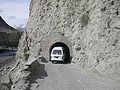
Road transport
Gilgit lies about 10 km off the Karakoram Highway. The KKH connects it to Chilas, Dasu, Besham, Mansehra, Abbottabad and Islamabad on the South. In the North it is connected to Karimabad (Hunza) and Sust in the Northern Areas and to the Chinese cities of Tashkurgan, Upal and Kashgar in Xinjiang.
Northern Areas Transport Corporation (NATCO) offers passenger road service between Islamabad, Gilgit, Sost and Tashkurgan, and road service between Kashgar and Gilgit (via Tashkurgan and Sust) starts in summer 2006. However, the border crossing between China and Pakistan at Khunjerab Pass (the highest border of the world) is open only between May 1 and October 15 of every year. During winter, the roads are blocked by snow. Even during the Monsoon season in summer, the roads are often blocked due to landslides. The best time to travel on Karakoram Highway is Spring or early Summer.
Air transport
Pakistan International Airlines flies brand new ATR42-500 flights twice daily between Gilgit Airport and Islamabad International Airport and the journey offers one of the most scenic areal views (especially from the cockpit) of the world as it passes close to Nanga Parbat and the mountain peaks are higher than the aircraft's cruising altitude. There are two routes that the aircraft takes one is the direct route from the capital Islamabad that takes it over the Margalla hill then over the town of Haripur direct over Kaghan valley from where it heads towards Nanga Parbat and finally abeam the mountain the descent starts into the Indus valley. The other route that it flies is all along the Indus valley which is also scenic but a little longer. The landing into Gilgit airport is pretty amazing and nerve wrecking for the faint hearted, but a must do for the adrenalin junkie provided you are allowed into the cockpit. These flights, however, are subject to the clearance of weather and in winters, flights are often delayed by several days. After a Fokker aircraft crashed near Multan, the Pakistani government banned all Fokker flights in domestic operations.
Hospitals
There are two major hospitals in Gilgit proper. The first is the DHQ or District Head Quarters which is the general hospital for the city. The Aga Khan Health Services Hospital is the other major health system including Emergency, Medicine, Paediatrics and Gynaecology Ops. It was started by Aga Khan in 1981 under the umbrella organization called (AKDN) (Aga Khan Development Network). It is generally considered the best hospital system in the entire Northern Areas.
Notable people
- Sher Jehan Mir- (President/CEO Karakuram Bank Ltd)
- Sardar Rasool Mir - former MNA and Chief of the Mir tribe
- Agha Zia-ud-din Rizvi - Religious leader
- Agha Rahat Al Hussaini - Head of Shia Sect Gilgit-Baltistan.
- Afzal Ali Shigri - former Inspector General of Police, Sindh
- Shukat Ali Khan - Mir of Nagar, Pakistan
- Mir Tazeem Akhtar - Finance Director, Karakorum International University
- G M Sikander - Principal Secretary to Chief Minister of Punjab
Picture Gallery
 Danyor Tanel
 Gilgit Valley
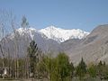 Gilgit Valley from Sonikot
 Broad View Of Gilgit Valley


References
- "The Gilgit Game" by John Keay (1985) ISBN 0-19-577466-3
- Drew, Frederic. Date unknown. The Northern Barrier of India: a popular account of the Jammoo and Kashmir Territories with Illustrations. Reprint: Light & Life Publishers, Jammu. 1971.
- Jettmar, Karl, 1980. Bolor & Dardistan. National Institute of Folk Heritage, Islamabad.
- Knight, E. F. 1893. Where Three Empires Meet: A Narrative of Recent Travel in: Kashmir, Western Tibet, Gilgit, and the adjoining countries. Longmans, Green, and Co., London. Reprint: Ch'eng Wen Publishing Company, Taipei. 1971.
- Leitner, G. W. 1893. Dardistan in 1866, 1886 and 1893: Being An Account of the History, Religions, Customs, Legends, Fables and Songs of Gilgit, Chilas, Kandia (Gabrial) Yasin, Chitral, Hunza, Nagyr and other parts of the Hindukush, as also a supplement to the second edition of The Hunza and Nagyr Handbook. And An Epitome of Part III of the author's “The Languages and Races of Dardistan. First Reprint 1978. Manjusri Publishing House, New Delhi.
- Muhammad, Gulam. 1980. Festivals and Folklore of Gilgit. National Institute of Folk Heritage, Islamabad.
- This article incorporates text from a publication now in the public domain: Chisholm, Hugh, ed. (1911). Encyclopædia Britannica (11th ed.). Cambridge University Press.
{{cite encyclopedia}}: Missing or empty|title=(help)