Shakhtarsk Raion
Shakhtarskyi Raion Шахтарський район | |
|---|---|
 | |
| Coordinates: 48°0′23″N 38°28′46.3″E / 48.00639°N 38.479528°E | |
| Country | |
| Region | Donetsk Oblast |
| Established | 1965 |
| Disestablished | 18 July 2020 |
| Admin. center | Shakhtarsk |
| Subdivisions | List
|
| Government | |
| • Governor | Dmytro Konakov |
| Area | |
• Total | 1,100 km2 (400 sq mi) |
| Population (2020) | |
• Total | |
| Time zone | UTC+02:00 (EET) |
| • Summer (DST) | UTC+03:00 (EEST) |
| Postal index | 86200-86263 |
| Area code | +380 6255 |
Shakhtarsk Raion (Ukrainian: Шахтарський район) was one of the raions of Donetsk Oblast, located in eastern Ukraine. The administrative center of the raion was the city of Shakhtarsk, which was incorporated separately as a city of oblast significance and was not part of the raion. The raion was abolished on 18 July 2020 as part of the administrative reform of Ukraine, which reduced the number of raions of Donetsk Oblast to eight.[1][2] However the raion has not been under control of the Ukrainian government since 2014, and has been part of the Donetsk People's Republic which in 2015 abolished it and subordinated to the city of Shakhtarsk.[3] The last estimate of the raion population, reported by the Ukrainian government, was 18,878 (2020 est.).[4]
Location
Shakhtarsk Raion was located in the eastern part of Donetsk Oblast and to its southeast it had an international border with Rostov Oblast of the Russian Federation. To its east it borders Luhansk Oblast.
To the south is Amvrosiivka Raion, and to its north, Bakhmut Raion. To the west of Shakhtars Raion stretched a chain of several cities with separate regional-level self-government such as Makiivka, Khartsyzk, Yenakieve, Zhdanivka. The raion also completely surrounded the cities of Shakhtarsk, Torez, and Snizhne.
War in Donbas

Shakhtarsk Raion had one international border crossing with the Russian Federation, Marynivka - Kuibyshevo. On June 5, 2014, the Government of Ukraine was forced to close the border crossing, due to multiple reports of unsanctioned crossings by militants from the Russian Federation. On June 6, 2014 intense fighting erupted at the Marynivka border checkpoint between Ukrainian border guards and militants who tried to cross into Ukraine from the Russian Federation.[citation needed]
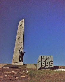
During the war in Donbas several battles took place around the Savur-Mohyla heights. The obelisk of the Savur-Mohyla Soviet memorial is depicted on the coat of arms and flag of Shakhtarsk Raion.
The Malaysia Airlines Flight 17, remnants of which scattered around the village of Hrabove, went down within the area of the raion.
On August 10–11, 2014 Ukrainian media claimed that the village of Stepanivka was completely destroyed by BM-21 Grad multi-rocket launcher systems fired from the territory of the Russian Federation.[5]
Demographics
As of the 2001 Ukrainian Census, the majority of residents are ethnic Ukrainians and speak Ukrainian as their first language:[6][7]
| Ethnicity | ||
|---|---|---|
| Ukrainians | 18,042 | 74.4% |
| Russians | 5,663 | 23.3% |
| Belarusians | 249 | 1.0% |
| Language | |
|---|---|
| Ukrainian | 53.36% |
| Russian | 46.25% |
| Belarusian | 0.12% |
| Armenian | 0.06% |
Localities
References
- ^ "Про утворення та ліквідацію районів. Постанова Верховної Ради України № 807-ІХ". Голос України (in Ukrainian). 2020-07-18. Retrieved 2020-10-03.
- ^ "Нові райони: карти + склад" (in Ukrainian). Міністерство розвитку громад та територій України. 17 July 2020.
- ^ "История города Шахтерска" (in Russian). City administration of Shakhtyorsk.
- ^ Чисельність наявного населення України на 1 січня 2020 року / Population of Ukraine Number of Existing as of January 1, 2020 (PDF) (in Ukrainian and English). Kyiv: State Statistics Service of Ukraine. Archived (PDF) from the original on 28 September 2023.
- ^ "Russian "Grads" completely destroyed Ukrainian village in Donetsk region". August 11, 2014. Archived from the original on August 12, 2014. Retrieved August 27, 2014.
- ^ "Home". ukrcensus.gov.ua.
- ^ "Національний склад та рідна мова населення Донецької області" [Ethnic and linguistic composition of Donetsk Oblast] (in Ukrainian). Archived from the original on 7 February 2012.
- ^ Зарощенское (in Russian). Donpatriot.ru. Retrieved 25 July 2014.


