Sentinel Dome
| Sentinel Dome | |
|---|---|
 Sentinel Dome | |
| Highest point | |
| Elevation | 8,127 ft (2,477 m) NAVD 88[1] |
| Prominence | 322 ft (98 m)[2] |
| Parent peak | Illilouette Ridge[3] |
| Coordinates | 37°43′23″N 119°35′03″W / 37.723094928°N 119.584304967°W[1] |
| Geography | |
| Location | Yosemite National Park, Mariposa County, California, U.S. |
| Parent range | Sierra Nevada |
| Topo map | USGS Half Dome |
| Geology | |
| Rock age | Cretaceous |
| Mountain type | Granite dome |
| Climbing | |
| Easiest route | Hike up northeast slope. |
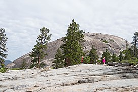
Sentinel Dome is a granite dome in Yosemite National Park, United States. It lies on the south wall of Yosemite Valley, 0.8 miles (1.3 km) southwest of Glacier Point and 1.4 miles (2.3 km) northeast of Profile Cliff.
The view from the top offers a 360 degree view of Yosemite Valley and surroundings. One can see Half Dome, El Capitan, Yosemite Falls, North Dome, Basket Dome, and much more. Sentinel Dome provides a 360 degree view of the night sky and it and nearby Glacier Point are popular places for stargazing.[4]
History
The original Native American name of Sentinel Dome, in the Southern Sierra Miwok language, was pronounced "Sak'-ka-du-eh".[5] The Bunnell survey named it "South Dome", but the Whitney survey renamed it Sentinel Dome (from its likeness to a watch-tower).[6]
Hiking trail
The trail to the base of Sentinel Dome is a relatively easy 1.1-mile (1.8 km) hike. The trailhead, the same as the Taft Point trailhead, is located 6 miles (9.7 km) from Bridalveil Creek on the Glacier Point road. Once at the base, hikers traverse the less imposing northeast granite slope to the summit.[7] In winter, Sentinel Dome can be reached from Badger Pass by a 10-miles ski tour.
Jeffrey Pine
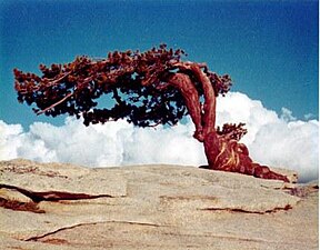
Sentinel Dome is known for a Jeffrey Pine that grew from its peak. The pine was photographed as early as 1867 by Carleton Watkins, and was the subject of a well-known photograph by Ansel Adams. The tree died during the drought of 1976,[8] but remained standing until August 2003.[8]
- The iconic Jeffrey Pine photographed August 7, 1968
- The dead Jeffery Pine in 2001
- The Jeffrey Pine shortly after it fell in 2003
References
- ^ a b "Sentinel Dome". NGS Data Sheet. National Geodetic Survey, National Oceanic and Atmospheric Administration, United States Department of Commerce. Retrieved 2012-03-30.
- ^ "Sentinel Dome, California". Peakbagger.com. Retrieved 2012-03-30.
- ^ "Sentinel Dome". ListsOfJohn.com.
- ^ "Yosemite Park Stargazing". scenicwonders.com. Retrieved 27 May 2013.
- ^ Powers, Stephen (1877). Tribes of California. University of California Press. p. 363. ISBN 9780520031722. Retrieved 14 September 2024.
- ^ Farquhar, Francis P. (1926). Place Names of the High Sierra. San Francisco: Sierra Club. Retrieved 2009-01-19.
- ^ "Day Hikes along the Glacier Point Road". National Park Service. Retrieved 2008-05-25.
- ^ a b "Famous Jeffrey Pine Falls on Sentinel Dome-Yosemite National Park". National Park Service. Archived from the original on 2008-11-19. Retrieved 2011-05-07.
External links
 Media related to Sentinel Dome at Wikimedia Commons
- "Sentinel Dome". Geographic Names Information System. United States Geological Survey, United States Department of the Interior.


