Sekiu, Washington
Sekiu, Washington | |
|---|---|
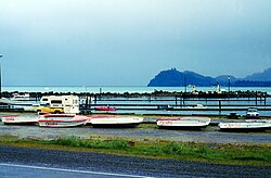
 Fishing boats out for the winter in Sekiu | |
| Coordinates: 48°15′45″N 124°18′4″W / 48.26250°N 124.30111°W | |
| Country | United States |
| State | Washington |
| County | Clallam |
| Settled | 1879 |
| Elevation | 20 ft (6 m) |
| Population (2010) | |
• Total | 27 |
| • Density | 211/sq mi (81.5/km2) |
| Time zone | UTC-8 (PST) |
| • Summer (DST) | UTC-7 (PDT) |
| ZIP code | 98381[1] |
| Area code | 360 |
Sekiu, a small fishing village[2], is an unincorporated community and census-designated place in Clallam County, Washington, United States. As of the 2020 census it had a population of 24.[3] Overlooking the west side of Clallam Bay and the Strait of Juan de Fuca, it is twinned with the community of Clallam Bay, on the east side of the bay.
The term "Sekiu" first appears as Sekou Pt on Henry Kellett's chart of 1846. Sekiu was first settled in 1879 by J.A. Martin who attempted to establish a salmon cannery there. Leather tanning and logging were other early industries in the area.
Sekiu has a small year-round population and is known primarily as a summer tourist destination for kayaking, birdwatching, diving, and fishing, particularly for salmon, halibut, lingcod, rockfish, and other bottomfish.[4] Additionally, whale watching can occur from the Sekiu overlook.[5]
Sekiu Airport is located a mile west of Sekiu and offers a 2,997-foot (913 m) lighted runway with a visual approach indicator, at an elevation of 350 feet (110 m).
Climate
The climate in this area has mild differences between highs and lows. Average year-round temperatures fall between 41F in winter to 58F in summer, with an average rainfall of 95 inches.[6] According to the Köppen Climate Classification system, Sekiu has a marine west coast climate, abbreviated "Cfb" on climate maps.[7]
| Climate data for Sekiu, Washington (1991-2020) | |||||||||||||
|---|---|---|---|---|---|---|---|---|---|---|---|---|---|
| Month | Jan | Feb | Mar | Apr | May | Jun | Jul | Aug | Sep | Oct | Nov | Dec | Year |
| Mean daily maximum °F (°C) | 46.0 (7.8) |
47.5 (8.6) |
49.8 (9.9) |
52.7 (11.5) |
57.6 (14.2) |
61.2 (16.2) |
64.9 (18.3) |
65.7 (18.7) |
63.7 (17.6) |
56.5 (13.6) |
50.2 (10.1) |
45.5 (7.5) |
55.1 (12.8) |
| Daily mean °F (°C) | 41.4 (5.2) |
42.1 (5.6) |
43.7 (6.5) |
46.4 (8.0) |
51.1 (10.6) |
54.7 (12.6) |
58.1 (14.5) |
58.5 (14.7) |
56.3 (13.5) |
50.4 (10.2) |
44.8 (7.1) |
41.0 (5.0) |
49.0 (9.5) |
| Mean daily minimum °F (°C) | 36.7 (2.6) |
36.5 (2.5) |
37.6 (3.1) |
40.1 (4.5) |
44.6 (7.0) |
48.4 (9.1) |
51.1 (10.6) |
51.4 (10.8) |
48.9 (9.4) |
44.1 (6.7) |
39.4 (4.1) |
36.3 (2.4) |
42.9 (6.1) |
| Average precipitation inches (mm) | 14.64 (371.83) |
8.91 (226.24) |
9.42 (239.17) |
5.69 (144.6) |
3.09 (78.55) |
1.95 (49.61) |
1.14 (29.07) |
1.34 (33.92) |
2.76 (70.03) |
7.95 (201.96) |
13.55 (344.09) |
12.98 (329.68) |
83.42 (2,118.75) |
| Average dew point °F (°C) | 37.2 (2.9) |
36.1 (2.3) |
37.9 (3.3) |
40.5 (4.7) |
45.0 (7.2) |
48.9 (9.4) |
52.3 (11.3) |
53.1 (11.7) |
50.5 (10.3) |
45.7 (7.6) |
40.5 (4.7) |
36.7 (2.6) |
43.7 (6.5) |
| Source: PRISM Climate Group [8] | |||||||||||||
References
- ^ "Sekiu WA ZIP Code". zipdatamaps.com. 2023. Retrieved June 16, 2023.
- ^ "SEKIU, Halfway to Alaska". TrollingFlies.com. March 4, 2019. Retrieved February 25, 2024.
- ^ "2020 Census Results". Retrieved February 19, 2024.
- ^ "Marine Area 5 - Sekiu and Pillar Point | Washington Department of Fish & Wildlife". wdfw.wa.gov. Retrieved February 19, 2024.
- ^ "Sekiu WA: Info and Photos of Sekiu on the Olympic Peninsula". www.myportangeles.com. Retrieved February 25, 2024.
- ^ "Sekiu WA: Info and Photos of Sekiu on the Olympic Peninsula". www.myportangeles.com. Retrieved February 25, 2024.
- ^ Climate Summary for Sekiu, Washington
- ^ "30-year monthly normals at:Latitude: 48.2626 Longitude: -124.3015 Elevation: 86m (282ft)". prism.oregonstate.edu. Based at Oregon State University. Northwest Alliance for Computational Science & Engineering. Retrieved March 19, 2024.
4km PRISM cells / not interpolated
{{cite web}}: CS1 maint: others (link)
External links
- Clallam Bay - Sekiu Chamber of Commerce
- History at Sekiu, Clallam County, Washington
- Port of Port Angeles - Sekiu Airport
- The Traveling Twins videoclip on Sekiu


