Scarr
| Scarr Mountain | |
|---|---|
| skajar | |
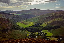
 Distinctive peak of Scarr, viewed from the R759 above the Luggala Estate | |
| Highest point | |
| Elevation | 641 m (2,103 ft)[1] |
| Prominence | 231 m (758 ft)[1] |
| Listing | Marilyn, Hewitt, Arderin, Simm, Vandeleur-Lynam |
| Coordinates | 53°03′19″N 6°18′41″W / 53.055277°N 6.311412°W |
| Naming | |
| English translation | sharp rock |
| Language of name | Irish |
| Geography | |
| Location | County Wicklow, Republic of Ireland |
| Parent range | Wicklow Mountains |
| OSI/OSNI grid | O1326801828 |
| Topo map | OSi Discovery 56 |
| Geology | |
| Mountain type(s) | Dark blue-grey slate, phyllite & schist[1] |
| Climbing | |
| Easiest route | Via Oldbridge at Lough Dan |
Scarr Mountain [2] at 641 metres (2,103 ft), is the 174th–highest peak in Ireland on the Arderin scale,[3] and the 207th–highest peak on the Vandeleur-Lynam scale.[4][5] Scarr is situated in the central sector of the Wicklow Mountains range, but off main "central spine" of the range that runs from Kippure in the north, to Lugnaquillia in the south.[6] Scarr lies on its own small massif that includes Scarr North-West Top 561 metres (1,841 ft) and Kanturk 523 metres (1,716 ft);[7] it is bounded by Lough Dan to the east and the Glenmacnass Valley on the west.[6] Scarr's sharp peak gives it a distinctive profile amongst the rounded summits of the Wicklow mountains, and it forms the backdrop to scenic views across the Guinness Estate and Lough Dan.[6][8]
Hill walking
A popular trail is the 14-kilometre (8.7 mi), four-to-five hour long Scarr and Kanturk Loop walk, which starts at a lay-by outside Oldbridge (O158019) at the southern end of Lough Dan. The recommended route is counter-clockwise, summiting Kanturk first and then crossing to the summit of Scarr before returning to Oldbridge.[9][10][11]
Gallery
- Scarr in Winter
- Scarr (left) from White Hill boardwalk on Djouce
- From the Guinness Estate
See also
- Wicklow Way
- Wicklow Round
- Wicklow Mountains
- Lists of mountains in Ireland
- List of mountains of the British Isles by height
- List of Marilyns in the British Isles
- List of Hewitt mountains in England, Wales and Ireland
References
- ^ a b c "Scarr". MountainViews Online Database. Retrieved 8 February 2019.
- ^ Paul Tempan (February 2012). "Irish Hill and Mountain Names" (PDF). MountainViews.ie.
- ^ Simon Stewart (October 2018). "Arderins: Irish mountains of 500+m with a prominence of 30m". MountainViews Online Database.
- ^ Simon Stewart (October 2018). "Vandeleur-Lynams: Irish mountains of 600+m with a prominence of 15m". MountainViews Online Database.
- ^ Mountainviews, (September 2013), "A Guide to Ireland's Mountain Summits: The Vandeleur-Lynams & the Arderins", Collins Books, Cork, ISBN 978-1-84889-164-7
- ^ a b c Dillion, Paddy (1993). The Mountains of Ireland: A Guide to Walking the Summits. Cicerone. ISBN 978-1852841102.
Walk 6: Tonelagee, Scarr
- ^ Michael Guilfoyle (12 June 2019). "Nine-hour hike across six beautiful mountains in Co Wicklow". Irish Times. Retrieved 26 July 2019.
- ^ Fairbairn, Helen (2014). Dublin & Wicklow: A Walking Guide. Collins Press. ISBN 978-1848892019.
Route 18: Tonelagee
- ^ Fairbairn, Helen (2014). Dublin & Wicklow: A Walking Guide. Collins Press. ISBN 978-1848892019.
Route 19: Scarr and Kanturk
- ^ "A Walk in Scarr". Ordnance Survey Ireland. 11 June 2015. Retrieved 28 July 2019.
- ^ Helen Fairbairn; Adrian Hendroff; John G O'Dwyer (8 April 2019). "30 best spring walks in Ireland: Fresh air for every age and fitness level!". Retrieved 28 July 2019.
12. Best for hikers: What Scarr and Kanturk Mountains, Co Wicklow
Bibliography
- Fairbairn, Helen (2014). Dublin & Wicklow: A Walking Guide. Collins Press. ISBN 978-1848892019.
- Fairbairn, Helen (2014). Ireland's Best Walks: A Walking Guide. Collins Press. ISBN 978-1848892118.
- MountainViews Online Database (Simon Stewart) (2013). A Guide to Ireland's Mountain Summits: The Vandeleur-Lynams & the Arderins. Collins Books. ISBN 978-1-84889-164-7.
- Dillion, Paddy (1993). The Mountains of Ireland: A Guide to Walking the Summits. Cicerone. ISBN 978-1852841102.
External links
- MountainViews: The Irish Mountain Website, Scarr
- MountainViews: Irish Online Mountain Database
- The Database of British and Irish Hills , the largest database of British Isles mountains ("DoBIH")
- Hill Bagging UK & Ireland, the searchable interface for the DoBIH


