Sandyville, Ohio
Sandyville, Ohio | |
|---|---|
 Sign at five-way intersection | |
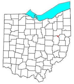
 Location of Sandyville, Ohio | |
| Coordinates: 40°38′49″N 81°22′01″W / 40.64694°N 81.36694°W | |
| Country | United States |
| State | Ohio |
| County | Tuscarawas |
| Township | Sandy |
| Elevation | 991 ft (302 m) |
| Population | |
• Total | 350 |
| Time zone | UTC-5 (Eastern (EST)) |
| • Summer (DST) | UTC-4 (EDT) |
| ZIP code | 44671 |
| GNIS feature ID | 2628966[1] |
Sandyville is an unincorporated community and census-designated place in northern Sandy Township, Tuscarawas County, Ohio, United States. It has a post office with the ZIP code 44671.[3] It lies along State Route 800 between Canton and New Philadelphia. The population was 350 at the 2020 census.
History
Sandyville was laid out and platted in 1815.[4] The community takes its name from nearby Sandy Creek.[5] A post office called Sandyville has been in operation since 1816.[6] The village was originally located a half-mile south next to Sandy Creek, but decided to move to its present site in the 1930s after the Muskingum Watershed Conservancy District announced plans to build a series of dams in the region that would have put the town inside a flood plain. About 30 homes, the town hall, post office and several businesses were physically moved uphill to the new site between 1937 and 1938.[7]
References
- ^ a b U.S. Geological Survey Geographic Names Information System: Sandyville, Ohio
- ^ "Sandyville CPD, Ohio - Census Bureau Profile". United States Census Bureau. Retrieved September 3, 2023.
- ^ USPS – Cities by ZIP Code
- ^ The History of Tuscarawas County, Ohio: Containing a History of the County; Its Townships, Towns, Churches, Schools, Etc. Warner, Beers & Company. 1884. p. 647.
- ^ Overman, William Daniel (1958). Ohio Town Names. Akron, OH: Atlantic Press. p. 123.
- ^ "Tuscarawas County". Jim Forte Postal History. Retrieved January 6, 2016.
- ^ Wang, Robert (July 25, 2015). "Sandyville honors its history with bicentennial celebration". The Repository. Canton, Ohio. Retrieved May 16, 2021.

