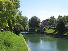
St. James's Bridge


St. James's Bridge (Slovene: Šentjakobski most) in Ljubljana is a bridge that crosses the Ljubljanica River on the southern end of downtown Ljubljana, next to Zois Manor. It links Zois Street (Zoisova cesta) and Karlovac Street (Karlovška cesta). The most important city traffic artery across the Ljubljanica runs across it.[1]
Background
A wooden bridge was constructed at this place in 1824, later than other bridges of the period, and for a long time it was therefore called the New Bridge (German: Neue Brücke). In 1915, it was replaced by a reinforced concrete corbel bridge by the engineer Alois Král and the architect Alfred Keller. It was described by the art historian Damjan Prelovšek as a "monumental neo-Biedermeier architectural language of late-Secession Vienna."[2]
Since 1954, there has been a plaque with an inscription on the bridge about a 15th-century town watermill, which caused damage to farmers and was destroyed in the 1515 peasant revolt.[3] Four bronze relief plaques depicting scenes from The Water Man, a Ljubljana-related Romantic ballad by the poet France Prešeren, were intended to be put on the fence of the bridge.[4] However, this has been never realised.[5]
References
- ^ Habič, Marko (1997). "Šentjakobski most" [St. James's Bridge]. Prestolnica Ljubljana nekoč in danes [A Pictorial Chronicle of a Capital City]. National Publishing House of Slovenia. ISBN 86-341-2007-4.
{{cite book}}:|work=ignored (help) - ^ "Šentjakobski most" [Šentjakob Bridge]. Ljubljana Tourism. Retrieved 25 May 2012.
- ^ Bric, Renato (28 March 2008). "Med mostovi slovenske prestolnice" [Among the Bridges of the Slovene Capital]. MMC RTV Slovenija (in Slovenian).
- ^ Dobida, Karel (1936). "In memoriam S.M. Peruzzi". Ljubljanski zvon. Vol. 56, no. 8. ISSN 1408-5909.
- ^ Meze (11 January 1983). "Nedokončani most" [Unfinished Bridge]. Naša komuna - delegatska priloga. Vol. 20, no. 1. p. 489.
External links
 Media related to St. James's Bridge at Wikimedia Commons
46°2′45.13″N 14°30′20.12″E / 46.0458694°N 14.5055889°E
