Rockfield, Monmouthshire
| Rockfield | |
|---|---|
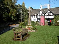
 Rockfield village green and war memorial | |
Location within Monmouthshire | |
| OS grid reference | SO482149 |
| Community | |
| Principal area | |
| Preserved county | |
| Country | Wales |
| Sovereign state | United Kingdom |
| Post town | MONMOUTH |
| Postcode district | NP25 |
| Dialling code | 01600 |
| Police | Gwent |
| Fire | South Wales |
| Ambulance | Welsh |
| UK Parliament | |
Rockfield is a small village in the community of Whitecastle, Monmouthshire, Southeast Wales. It is located beside the River Monnow, about 2 miles (3.2 km) north-west of Monmouth, at the junction of the B4233 to Abergavenny and the B4347 to Grosmont. Rockfield Studios is situated just south of the village.[1]
Placename
The use of the English name, Rockfield, is first documented in 1566. However, it is believed that the name dates back to the 11th century, being derived from the French, Rocheville. The pre-Norman name for the settlement was Llanoronwy, and the Welsh Academy dictionary still gives the Welsh language name for the village as Llanoronwy Carn Cenhedlon. There was some controversy late in 2010, when Monmouthshire County Council reintroduced the Welsh name on local signage.[2] The name was removed from the signs in 2011 after complaints from villagers.[3][4]
Church of St Cenedlon
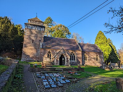
The village church is dedicated to an early Welsh saint, Cenedlon, who may have been the wife of Arthfael ab Ithel, king of Gwent in the 7th century.[5] Some old sources show it as being also dedicated to Saint Kenelm, a 9th-century Mercian martyr.[6] However, the Welsh name Llanoronwy appears to derive from a third name, Goronwy.
The church tower is mediaeval, but the rest of the church was rebuilt and refitted in 1859–60 by John Prichard and John Pollard Seddon in the Early English and Perpendicular styles. It contains a painted coat of arms of William III, dated 1700.[7]
It also contains, beneath the altar, the grave of Bishop Matthew Pritchard, the Catholic Vicar Apostolic of the Western District between 1713 and 1744. In retirement, he lived with a Catholic family in a mediaeval mansion, Perthîr, beside the river; the house was demolished around 1830.[8]
Other notable buildings
Several buildings in and around the village were constructed as part of the Rolls estate. One of the entrance lodges to the family home at The Hendre, 2 miles (3.2 km) to the west, is sited immediately north of the village. Almshouses, provided in 1906 by Lord Llangattock for retired estate workers, are located beside the main road south of the village. They were designed by Aston Webb and built in local Old Red Sandstone with half-timbering.[7] To the north of the village, Pentwyn is a house designed and occupied from 1837 by the Monmouth architect George Vaughan Maddox, and later extended as a parsonage.[7]
Politics
The village falls under the community of Llangattock-Vibon-Avel and the constituency of Monmouth.
Gallery
- St Cenedlon church
- Gateway at Rockfield leading to The Hendre
- Road sign containing English and the contentious Welsh name
References
- ^ "Rockfield Studios, The Legendary Welsh Recording Studios".
- ^ "Community campaigns to get rid of Welsh place name". BBC News. 14 December 2010. Retrieved 1 June 2011.
- ^ "Rockfield and Cross Ash signs have Welsh names removed". 1 June 2011. BBC News. 1 June 2011. Retrieved 1 June 2011.
- ^ James, Eleri Hedd (2022). "Sign of the Times: Onomastics and Language Policy in Wales". In McLeod, Wilson; Dunbar, Robert; Jones, Kathryn; Walsh, John (eds.). Language, Policy and Territory: A Festschrift for Colin H. Williams. Basingstoke: Palgrave Macmillan. p. 190. doi:10.1007/978-3-030-94346-2. ISBN 978-3-030-94345-5. OCLC 1336402969.
- ^ Baring-Gould, Sabine; Fisher, John (June 2005). Sabine Baring-Gould, The Lives of the British Saints: The Saints of Wales, Cornwall and Irish Saints, Volume 2, p.455. ISBN 9780766187658.
- ^ Lewis, Samuel (4 March 1831). "A Topographical Dictionary of England: Comprising the Several Counties, Cities, Boroughs, Corporate and Market Towns, Parishes, Chapelries, and Townships, and the Islands of Guernsey, Jersey, and Man, with Historical and Statistical Descriptions; Illustrated by Maps of the Different Counties and Islands; a Map of England ... and a Plan of London and Its Environs ... : in Four Volumes". Lewis – via Google Books.
- ^ a b c John Newman, The Buildings of Wales: Gwent/Monmouthshire, Penguin Books, 2000, ISBN 0-14-071053-1, pp. 517–518
- ^ The Catholic Registers of Perthîr in the County of Monmouth, 1758–1818. Accessed 5 February 2012


