Pular (volcano)
| Pular | |
|---|---|
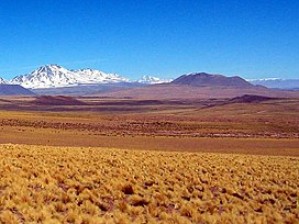
 Miñiques surrounding area with Pular, Cerro Pajonales and Socompa in the distance. | |
| Highest point | |
| Elevation | 6,233 m (20,449 ft)[1] |
| Prominence | 1,898 m (6,227 ft)[2] |
| Listing | Ultra |
| Coordinates | 24°11′15″S 68°03′15″W / 24.18750°S 68.05417°W[1] |
| Naming | |
| English translation | The Eyebrow |
| Language of name | Kunza |
| Geography | |
| Location | Antofagasta Region, Chile |
| Parent range | Andes |
| Geology | |
| Mountain type | Stratovolcanoes |
| Last eruption | Unknown[1] |
| Climbing | |
| First ascent | Inca, pre-Columbian[3] |
Pular is a massive stratovolcano located in the Antofagasta Region of northern Chile, about 15 km west of the border with Argentina, which in this area is a straight line between the summits of Socompa volcano and Cerro del Rincón. Pular, along with Cerro Pajonales, forms a high volcanic ridge, which runs in a generally north-east to south-west direction for 12 km (7 mi). Southward, following the same direction as the ridge, lies Socompa volcano. The ridge's crest forms a drainage divide between Salar de Atacama basin and Salar de Pular basin. This latter is a bowl-shaped basin enclosed on the east by Aracar volcano.
In the Kunza language Pular means "The Eyebrow"[3] and the volcano was a site of Inka cultural activity.[4]
Geology and geomorphology
The Andes of northern Chile are formed by a number of volcanoes, some of which reach 6,000 metres (20,000 ft) elevation. During winter they are covered with snow but the climate of the region is arid and the snow disappears during the summer months; only on some high summits like Ojos del Salado and Llullaillaco does ice exist. However, traces of past glaciation occur on other volcanoes.[5]
The Pajonales-Pular volcanic massif has a volume exceeding 100 cubic kilometres (24 cu mi)[6] and is formed by andesitic and dacitic rocks[7] and covers an area of 300 square kilometres (120 sq mi) on faulted Miocene sediments. The massif consists of an alignment of volcanoes and two subunits, a heavily eroded unit that consists of Pajonales and Pular proper[8] and a younger unit consisting of volcanic domes. These domes reach heights of 0.8–1 kilometre (0.50–0.62 mi) and one of these overlies a glacial moraine. Rocks of the older unit are 3.9 million years old, while one of the domes has been dated to be 1.8 million years old.[7] Unverified reports indicate an explosive eruption in 1990, but the region is remote and renewed activity is unlikely to have any impact.[9]
Numerous moraines occur within the drainage network of Pajonales-Pular.[10] The mountain was extensively glaciated in the past, with five glacier systems on its northwestern and six on the southeastern slopes. The glaciers reached lengths of 6 kilometres (3.7 mi) and formed moraines at less than 5 kilometres (3.1 mi) elevation. A snowfield presently occupies one of the areas on the southeastern slopes that was formerly glaciated,[11] and ephemeral lakes filled with snowmelt water occasionally appear on the mountain.[12]
See also
- List of volcanoes in Chile
- List of Ultras of South America
- Caichinque
- Monturaqui crater
- List of andean peaks with known pre-columbian ascents
References
- ^ a b c "Pular". Global Volcanism Program. Smithsonian Institution. Retrieved 2010-04-10.
- ^ "Argentina and Chile North: Ultra-Prominences" Peaklist.org. Retrieved 2013-02-26.
- ^ a b Humberto Barrera, "Cerro Pular", American Alpine Journal, 1974, p. 194. Available at AAJ Online Archived 2007-09-27 at the Wayback Machine (PDF).
- ^ Valenzuela, América; Moyano, Ricardo (2021). "Ethnicity and Ritual in the Atacameños Andes: Water, Mountains, and Irrigation Channels in Socaire (Atacama, Chile)". Andean Foodways: Pre-Columbian, Colonial, and Contemporary Food and Culture. Springer International Publishing. p. 435. doi:10.1007/978-3-030-51629-1_17. ISBN 978-3-030-51629-1. S2CID 229411986.
- ^ Ramirez 1988, p. 144.
- ^ Grosse, Pablo; Orihashi, Yuji; Guzmán, Silvina R.; Sumino, Hirochika; Nagao, Keisuke (4 April 2018). "Eruptive history of Incahuasi, Falso Azufre and El Cóndor Quaternary composite volcanoes, southern Central Andes". Bulletin of Volcanology. 80 (5): 44. Bibcode:2018BVol...80...44G. doi:10.1007/s00445-018-1221-5. ISSN 1432-0819. S2CID 134869390.
- ^ a b Ramirez 1988, p. 148.
- ^ Ramirez 1988, p. 147.
- ^ Amigo, Álvaro R.; Bertin, Daniel U.; Orozco, Gabriel L. (2012). Peligros volcánicos de la Zona Norte de Chile (PDF) (Report). Carta geológica de Chile: Serie Geología Ambiental (in Spanish). Vol. 17. SERVICIO NACIONAL DE GEOLOGÍA Y MINERÍA. p. 20. ISSN 0717-7305. Archived from the original (PDF) on June 29, 2021. Retrieved 20 August 2021.
- ^ Ramirez 1988, p. 145.
- ^ Jenny, Bettina; Kammer, Klaus (1996). Climate Change in den trockenen Anden (in German). Verlag des Geographischen Institutes der Universität Bern. pp. 60–63. ISBN 3906151034.
- ^ Ramirez 1988, p. 151.
Sources
- Ramirez, C.F. (12 August 1988). Evidencias de Glaciación en el Macizo de los Volcanes Pular y Pajonales, Región de Antofagasta (PDF). V Congreso Geologico Chileno (in Spanish). Santiago. Archived from the original (PDF) on December 30, 2019.}

