Port Murray Historic District
Port Murray Historic District | |
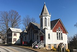
 McCrea Memorial Methodist Church on Main Street | |
| Location | Roughly, Port Murray Road from Cherry Tree Bend Road to Hoffman Road Port Murray, New Jersey |
|---|---|
| Coordinates | 40°47′31″N 74°54′51″W / 40.79194°N 74.91417°W |
| Area | 88 acres (36 ha) |
| Built | 1828 |
| Architectural style | Italianate, Second Empire, Carpenter Gothic |
| NRHP reference No. | 96000658[1] |
| NJRHP No. | 3499[2] |
| Significant dates | |
| Added to NRHP | June 7, 1996 |
| Designated NJRHP | April 26, 1996 |
The Port Murray Historic District is a 88-acre (36 ha) historic district in the Port Murray section of Mansfield Township in Warren County, New Jersey, United States. It was an important transportation location, being on the Morris Canal and the Morris and Essex Railroad. The district was added to the National Register of Historic Places on June 7, 1996 for its significance in community development, architecture, and transportation from 1828 to 1915.[1] It includes 82 contributing buildings, 7 contributing sites, and 12 contributing structures.[3]
History and description
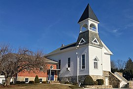
The community grew after the completion of the Morris Canal in 1831. It had a boat basin and was located near Inclined Plane 5 West. The canal store was built in 1836. The Morris and Essex Railroad was constructed in 1850. The train station was built around 1909–1914 and handled both passenger and freight trains. The McCrea Memorial Methodist Church was built in 1895 and features Shingle style architecture. The Italianate house built by Samuel McCrea around 1860–1873 became the Methodist Church Parsonage in 1898. The former Mansfield Baptist Church was built in 1842, with the belfry added in 1894.[3]
Gallery
- Canal Store on the Morris Canal
- Former train station on the Morris and Essex Railroad
- Built by Samuel McCrea, used as Methodist Church Parsonage
- Franco-Italianate Second Empire style house
- Former Mansfield Baptist Church, currently the Abundant Life Community Church
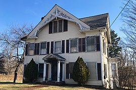
- Carpenter Gothic style house
See also
- National Register of Historic Places listings in Warren County, New Jersey
- List of bridges on the National Register of Historic Places in New Jersey
- Port Colden Historic District
References
- ^ a b "National Register Information System – (#96000658)". National Register of Historic Places. National Park Service. November 2, 2013.
- ^ "New Jersey and National Registers of Historic Places – Warren County" (PDF). New Jersey Department of Environmental Protection – Historic Preservation Office. December 27, 2023. p. 7.
- ^ a b Greiff, Constance M. (December 1994). "National Register of Historic Places Inventory/Nomination: Port Murray Historic District". National Park Service. With accompanying 22 photos
External links
 Media related to Port Murray Historic District at Wikimedia Commons
- "Morris Canal: Inclined Plane 5 West". The Historical Marker Database.
- "Main Street (CR629) over Washington Secondary DL&W RR" (PDF). New Jersey Historic Bridge Data: Warren County. New Jersey Department of Transportation: 158.
Structure# 2154166
- "Port Murray (CR629) over Washington Sec (Conrail)". Bridge Reports – via National Bridge Inventory.


