Plumwood, Ohio
Plumwood, Ohio | |
|---|---|
 Monroe Township hall | |
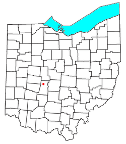
 Location of Plumwood, Ohio | |
| Coordinates: 40°00′32″N 83°24′53″W / 40.00889°N 83.41472°W | |
| Country | United States |
| State | Ohio |
| County | Madison |
| Township | Monroe |
| Area | |
• Total | 0.62 sq mi (1.61 km2) |
| • Land | 0.62 sq mi (1.61 km2) |
| • Water | 0.00 sq mi (0.00 km2) |
| Elevation | 1,007 ft (307 m) |
| Population (2020) | |
• Total | 257 |
| • Density | 413.18/sq mi (159.61/km2) |
| Time zone | UTC-5 (Eastern (EST)) |
| • Summer (DST) | UTC-4 (EDT) |
| FIPS code | 39-63758 |
| GNIS feature ID | 2628953[2] |
Plumwood is a census-designated place in central Monroe Township, Madison County, Ohio, United States.[3] It lies at the intersection of State Route 38 with Arthur Bradley Road, 8½ miles (13½ km) north of the city of London, the county seat of Madison County. The Spring Fork of the Little Darby Creek flows past the community.[4]
History
Plumwood was originally laid out on December 23, 1895, by Charles F. Sanford. The community was originally named Sanford, but the name was later changed.[5] As of 1915, the community was one of the largest trade posts in the county, with three large general stores, a blacksmith, six threshing outfits, three hay baling outfits, and the population was 200.[5]
| Census | Pop. | Note | %± |
|---|---|---|---|
| 2020 | 257 | — | |
| U.S. Decennial Census[6] | |||
Education
It is in the Jonathan Alder School District,[7] which operates Jonathan Alder High School.
References
- ^ "ArcGIS REST Services Directory". United States Census Bureau. Retrieved September 20, 2022.
- ^ a b U.S. Geological Survey Geographic Names Information System: Plumwood, Ohio
- ^ U.S. Geological Survey Geographic Names Information System: Plumwood, Ohio
- ^ DeLorme. Ohio Atlas & Gazetteer. 7th ed. Yarmouth: DeLorme, 2004, pp. 57, 67. ISBN 0-89933-281-1.
- ^ a b Bryan, Chester E., History of Madison County, Ohio, B.F. Bowen & Company, Inc., Indianapolis, Indiana, 1915, Pg. 181.
- ^ "Census of Population and Housing". Census.gov. Retrieved June 4, 2016.
- ^ "2020 CENSUS - SCHOOL DISTRICT REFERENCE MAP: Madison County, OH" (PDF). U.S. Census Bureau. Retrieved September 18, 2024. - Text list

