Pilling Sands
| Pilling Sands | |
|---|---|
 People walking on the sands, with Heysham Power Station, located to the north, in the background | |
| Geography | |
| Country | England |
| District | Wyre, Lancashire |
| Population center | Pilling |
| Coordinates | 53°57′N 2°55′W / 53.95°N 2.92°W |
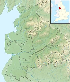
Pilling Sands is a tidal marsh in the Borough of Wyre, Lancashire, England. Named after the village of Pilling, located on the Fylde coast immediately to the south,[1] it forms part of the southern edge of Morecambe Bay.[2] Cockerham Sands adjoins it to the east.
The 134-mile (216 km)-long Lancashire Coastal Way runs beside the sands. This section is closed from 26 December to Good Friday to protect lambs and birdlife.[3] Rare birds for Lancashire that have been spotted near the sands include lesser yellowlegs and hoopoe.[4]
In 2022, the North West Inshore Fisheries and Conservation Authority found that the Pilling Sands cockle fishery was, in a Habitats Regulations Assessment, in non-compliance of the North West Sea Fisheries Commission byelaw 13A, and was subsequently closed temporarily.[5] Closure notices are active until two consecutive samples return normal levels of bacteriological quality for the production area.[6]
Horse racing regularly took place on the sands in the 19th century.[7]
References
- ^ "#GetOutside: do more in the British Outdoors". OS GetOutside. Retrieved 2022-11-01.
- ^ Evans, Denise (2022-08-07). "Coastal village with a salt marsh beach, windmill and a bug hotel". LancsLive. Retrieved 2022-11-01.
- ^ "Play-Dogs: L'application mobile pour découvrir et partager des balades avec ton chien". Play-Dogs: Let's dog it ! (in French). Retrieved 2022-11-01.
- ^ "Pilling Birdwatching Site - BirdGuides". www.birdguides.com. Retrieved 2022-11-01.
- ^ "Pilling Sands and Newbiggin Cockle Fishery HRA Review Update". IFCA North West. 2022-01-14. Retrieved 2022-11-01.
- ^ Grieve, Leo. "Shellfish harvesting". Wyre Council. Retrieved 2022-11-01.
- ^ Our Country Churches and Chapels. A. Hewitson. 1872. p. 498.


