Pemberton Point
Pemberton Point Windmill Point | |
|---|---|
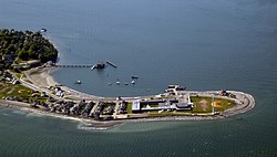
 Aerial view of Pemberton Point, 2008 | |
| Coordinates: 42°18′17″N 70°55′10″W / 42.30472°N 70.91944°W | |
| Country | United States |
| State | Massachusetts |
| County | Plymouth |
| Town | Hull |
| Time zone | UTC-5 (Eastern) |
| • Summer (DST) | UTC-4 (Eastern) |
| ZIP code | 02045 |
| Area code(s) | 339 / 781 |
Pemberton Point (formerly known as Windmill Point) is a peninsula in Hull, Massachusetts. It is located at the tip of the Nantasket Peninsula, in Boston Harbor.
History
Historic manuscripts have called the location "Windmill Point" since the 1820s.[1] The windmills for which the point were named were used by two brothers to pump seawater into vats to be used for harvesting salt.[1][2][3] The salt would then be used to pack fish.[2]
On July 13, 1909, fourteen-year-old Rosie Pitenhof swam across the Hull Gut from Peddocks Island to Pemberton Point and back, believed to be the first to do so.[4]
Hull High School, the town's public high school, opened on the point in 1957.[5]
Wind turbines

An Enertech 40 kW wind turbine was installed on Pemberton Point and started energy production in March 1985.[6][7] The turbine was funded by the Massachusetts Department of Energy Resources, and was sited adjacent to the high school.[7] It was damaged beyond repair by a storm in March 1997,[1][7] and was removed after a new wind turbine, nicknamed "Hull Wind 1", was installed nearby at the end of 2001.[6]
Hull Wind 1
Hull Wind 1, a new Vestas V47 turbine capable of producing 660 kW, began producing power on Pemberton Point in December 2001. It stands 150 feet (46 m) tall.[8] It is the first commercial wind turbine on the East Coast of the United States[6] and in the whole of New England.[1] It is also the first commercial urban turbine in North America.[6] During its first year of operation, it saved Hull over $100,000.[2] In 2003, planning began for an additional wind turbine known as "Hull Wind 2".[7] It was initially suggested that it be located near Hull Wind 1, but after concerns were expressed by nearby residents over having two in close proximity, the new Vestas V80 1.8 MW wind turbine was installed on a landfill to the east, away from Pemberton Point, and began operation in May 2006.[1]
Facilities
The United States Coast Guard Station Point Allerton was built in 1969 and is located near the point.[9] It was commissioned on April 18, 1970.[10] Point Allerton Lifesaving Station, which opened on October 15, 1889,[10] used to hold the United States Coast Guard before the present station was built.
The Massachusetts Bay Transportation Authority runs boats from Pemberton Point to both Long Wharf and Logan Airport.[11]
Pemberton Point Pier is a popular fishing location.[12]
See also
References
- ^ a b c d e Manwell, James F.; MacLeod, John; Wright, Sally; DiTullio, Lynn; McGowan, Jon G (June 2006). "Hull Wind II: A Case Study of the Development of a Second Large Wind Turbine Installation in the Town of Hull, MA" (PDF). American Wind Energy Association. Archived from the original (PDF) on November 2, 2013. Retrieved June 5, 2012.
- ^ a b c Cherry, Jonathan S. (June 2008). "The windy city: Harnessing Power in the Neighborhood Landscape" (PDF). Massachusetts Institute of Technology. pp. 19, 22. Archived from the original (PDF) on November 2, 2013. Retrieved July 22, 2012.
- ^ Sweeney, Emily (January 23, 2011). "Hull harvests rewards of wind power". The Boston Globe. Retrieved July 11, 2012.
- ^ "Girl Swims Hull Gut: 14-Year-old Miss First Person to Accomplish Hard Task at Boston" (PDF). The New York Times. July 14, 1909. Retrieved July 8, 2012.
- ^ "Hull High School: 2011 - 2012 School Profile" (PDF). Hull High School. p. 1. Archived from the original (PDF) on March 28, 2012. Retrieved July 11, 2012.
- ^ a b c d Manwell, J. F.; McGowan, J. G.; Rogers, A.; Ellis, A.; Wright, S. (2003). "Wind Turbine Siting in an Urban Environment: The Hull, MA 660 KW Turbine" (PDF). American Wind Energy Association. p. 10. Archived from the original (PDF) on October 21, 2013. Retrieved July 22, 2012.
- ^ a b c d "History of Hull's wind project". HullWind.org. 2006. Retrieved July 10, 2012.
- ^ "Hull Wind: 6,000,000 kWhs of clean energy" (PDF). HullWind.org. December 1, 2005. Retrieved July 10, 2012.
- ^ "Massachusetts, Hull, Plymouth Co". Sail 1620. 2012. Archived from the original on June 9, 2012. Retrieved June 7, 2012.
- ^ a b "History - Station Point Allerton". United States Coast Guard. January 26, 2012. Retrieved July 12, 2012.
- ^ "Boat Map and Schedules". MBTA. Retrieved August 8, 2013.
- ^ Broach, Heidi. "Massachusetts Onshore Fishing Hot Spots". USA Today. Retrieved July 25, 2012.

