Osku County
Osku County Persian: شهرستان اسکو | |
|---|---|
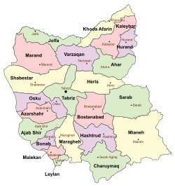
 Location of Osku County in East Azerbaijan province (center left, purple) | |
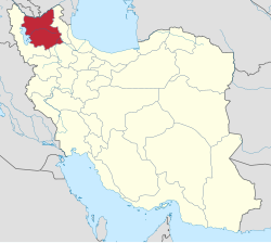
 Location of East Azerbaijan province in Iran | |
| Coordinates: 37°53′30″N 45°51′00″E / 37.89167°N 45.85000°E[1] | |
| Country | Iran |
| Province | East Azerbaijan |
| Capital | Osku |
| Districts | Central, Ilkhchi |
| Population (2016)[2] | |
• Total | 158,270 |
| Time zone | UTC+3:30 (IRST) |
| Osku County can be found at GEOnet Names Server, at this link, by opening the Advanced Search box, entering "9205846" in the "Unique Feature Id" form, and clicking on "Search Database". | |
Osku County (Persian: شهرستان اسکو) is in East Azerbaijan province, Iran. Its capital is the city of Osku.[3]
Osku is one of the oldest cities in East Azerbaijan, according to old books, and is like stepping into a time machine. The city is located on a volcano hillside and has many caves in the city. Attractions such as Kandovan and natural landscapes make Osku one of the touristic cities in Iran. It is one of the few cities in Iran where batik printing centers still remain in operation. Osku is presently known as the capital of batik in Iran. Hilleh Historical Village is another historical village near to the city, currently abandoned.
History
After the 2006 National Census, the village of Sahand was elevated to the status of a city.[4]
Demographics
Ethnicity
The inhabitants of Osku are Azerbaijani Turks, who have lived in the city for more than 100 years.[citation needed]
Population
At the time of the 2006 census, the county's population was 84,061 in 23,613 households.[5] The following census in 2011 counted 98,988 people in 30,091 households.[6] The 2016 census measured the population of the county as 158,270 in 50,674 households.[2]
Administrative divisions
Osku County's population history and administrative structure over three consecutive censuses are shown in the following table.
| Administrative Divisions | 2006[5] | 2011[6] | 2016[2] |
|---|---|---|---|
| Central District | 56,253 | 69,116 | 127,452 |
| Bavil RD | 23,318 | 9,792 | 9,397 |
| Gonbar RD | 7,315 | 7,704 | 7,763 |
| Sahand RD | 9,480 | 9,933 | 9,339 |
| Osku (city) | 16,140 | 16,983 | 18,459 |
| Sahand (city) | 24,704 | 82,494 | |
| Ilkhchi District | 27,808 | 29,872 | 30,818 |
| Jazireh RD | 3,574 | 3,014 | 2,499 |
| Shurakat-e Jonubi RD | 10,307 | 11,627 | 11,745 |
| Ilkhchi (city) | 13,927 | 15,231 | 16,574 |
| Total | 84,061 | 98,988 | 158,270 |
| RD = Rural District | |||
See also
![]() Media related to Osku County at Wikimedia Commons
Media related to Osku County at Wikimedia Commons
References
- ^ OpenStreetMap contributors (5 September 2024). "Osku County" (Map). OpenStreetMap (in Persian). Retrieved 5 September 2024.
- ^ a b c Census of the Islamic Republic of Iran, 1395 (2016): East Azerbaijan Province. amar.org.ir (Report) (in Persian). The Statistical Center of Iran. Archived from the original (Excel) on 13 November 2020. Retrieved 19 December 2022.
- ^ Habibi, Hassan (10 November 1392) [Approved 17 April 1376]. Changes in country divisions in East Azarbaijan province. rc.majlis.ir (Report) (in Persian). Ministry of the Interior, Political-Defense Commission of the Government Board. Notification 57400 17940 K. Archived from the original on 30 January 2014. Retrieved 6 December 2023 – via Research Center of the System of Laws of the Islamic Council of the Farabi Library of Mobile Users.
- ^ "Details of the establishment of the new city Shahriar by the private sector". ahrabnews.com (in Persian). 30 May 2015. Archived from the original on 29 May 2015. Retrieved 22 February 2023.
- ^ a b Census of the Islamic Republic of Iran, 1385 (2006): East Azerbaijan Province. amar.org.ir (Report) (in Persian). The Statistical Center of Iran. Archived from the original (Excel) on 20 September 2011. Retrieved 25 September 2022.
- ^ a b Census of the Islamic Republic of Iran, 1390 (2011): East Azerbaijan Province. irandataportal.syr.edu (Report) (in Persian). The Statistical Center of Iran. Archived from the original (Excel) on 16 January 2023. Retrieved 19 December 2022 – via Iran Data Portal, Syracuse University.

