Narrows, Virginia
Town of Narrows, Virginia | |
|---|---|
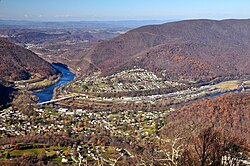
 Narrows, Virginia in November 2013. | |
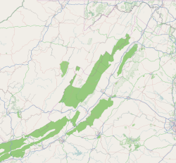
| Coordinates: 37°19′55″N 80°48′31″W / 37.33194°N 80.80861°W | |
| Country | United States |
| State | Virginia |
| County | Giles |
| Government | |
| • Mayor | John Davis |
| Area | |
• Total | 1.34 sq mi (3.47 km2) |
| • Land | 1.27 sq mi (3.28 km2) |
| • Water | 0.07 sq mi (0.19 km2) 4.5% |
| Elevation | 1,545 ft (471 m) |
| Population (2010) | |
• Total | 2,029 |
• Estimate (2019)[2] | 1,952 |
| • Density | 1,540.65/sq mi (595.04/km2) |
| U.S. Census Bureau, 2010 Census Count | |
| Time zone | UTC−5 (EST) |
| • Summer (DST) | UTC−4 (EDT) |
| ZIP code | 24124 |
| Area code | 540 |
| FIPS code | 51-54904[3] |
| GNIS feature ID | 1497034[4] |
| Website | http://www.townofnarrows.org/ |
Narrows, named for the narrowing of the New River that flows through the town, is a town in Giles County, Virginia, United States. The population was 2,029 at the 2010 census, a decline of 3.9% from the 2000 count of 2,111. It is part of the Blacksburg–Christiansburg Metropolitan Statistical Area.
Geography
Narrows is located at 37°19′55″N 80°48′31″W / 37.33194°N 80.80861°W (37.331818, −80.808477).[5]
The town is just north of the Mill Creek (conservation area), an area in the Jefferson National Forest designated by the Wilderness Society as a "Mountain Treasure".[6]
According to the United States Census Bureau, the town has a total area of 1.3 square miles (3.5 km2), of which 1.3 square miles (3.3 km2) is land and 0.1 square mile (0.2 km2) (4.48%) is water.
Demographics
| Census | Pop. | Note | %± |
|---|---|---|---|
| 1910 | 975 | — | |
| 1920 | 1,141 | 17.0% | |
| 1930 | 1,345 | 17.9% | |
| 1940 | 1,489 | 10.7% | |
| 1950 | 2,520 | 69.2% | |
| 1960 | 2,508 | −0.5% | |
| 1970 | 2,421 | −3.5% | |
| 1980 | 2,516 | 3.9% | |
| 1990 | 2,082 | −17.2% | |
| 2000 | 2,111 | 1.4% | |
| 2010 | 2,029 | −3.9% | |
| 2019 (est.) | 1,952 | [2] | −3.8% |
| U.S. Decennial Census[7] | |||
Detailed breakdowns of the 2010 census numbers are not yet available.
At the 2000 census there were 2,111 people, 890 households, and 600 families in the town. The population density was 1,649.7 people per square mile (636.8/km2). There were 971 housing units at an average density of 758.8 per square mile (292.9/km2). The racial makeup of the town was 98.86% White, 0.24% African American, 0.05% Native American, 0.05% Asian, 0.28% from other races, and 0.52% from two or more races. Hispanic or Latino of any race were 0.43%.[3]
Of the 890 households 27.9% had children under the age of 18 living with them, 53.1% were married couples living together, 10.3% had a female householder with no husband present, and 32.5% were non-families. 29.6% of households were one person and 16.2% were one person aged 65 or older. The average household size was 2.35 and the average family size was 2.90.
The age distribution was 22.9% under the age of 18, 7.2% from 18 to 24, 28.3% from 25 to 44, 23.3% from 45 to 64, and 18.4% 65 or older. The median age was 39 years. For every 100 females, there were 85.0 males. For every 100 females aged 18 and over, there were 81.5 males.
The median household income was $31,875 and the median family income was $42,610. Males had a median income of $31,806 versus $22,222 for females. The per capita income for the town was $17,933. About 5.4% of families and 8.7% of the population were below the poverty line, including 11.4% of those under age 18 and 11.9% of those age 65 or over.
History
Settled as early as 1778, a post office was opened in 1873 and the town was incorporated in 1904.[8]
From 1946–1950, the New River Rebels were a minor league baseball team representing Narrows and Pearisburg, Virginia . The New River Rebels were a member of the Class D Appalachian League from 1946–1950. The Rebels captured Appalachian League Championships in 1946 and 1947. The New River Rebels were an affiliate of the Chicago White Sox in 1946 and played at Ragsdale Field.[9]
On December 22, 1996, Airborne Express Flight 827 crashed in Narrows, killing all six people on board.[10]
The Narrows Commercial Historic District was added to the National Register of Historic Places in 2014.
References
- ^ "2019 U.S. Gazetteer Files". United States Census Bureau. Retrieved August 7, 2020.
- ^ a b "Population and Housing Unit Estimates". United States Census Bureau. May 24, 2020. Retrieved May 27, 2020.
- ^ a b "U.S. Census website". United States Census Bureau. Retrieved January 31, 2008.
- ^ "US Board on Geographic Names". United States Geological Survey. October 25, 2007. Retrieved January 31, 2008.
- ^ "US Gazetteer files: 2010, 2000, and 1990". United States Census Bureau. February 12, 2011. Retrieved April 23, 2011.
- ^ Parsons, Shireen (May 1999). Virginia's Mountain Treasures, The Unprotected Wildlands of the Jefferson National Forest. Washington, D. C.: The Wilderness Society, OCLC: 42806366. p. 46.
- ^ "Census of Population and Housing". Census.gov. Retrieved June 4, 2015.
- ^ Tennis, Joe (2004). Southwest Virginia Crossroads. Johnson City, Tennessee: The Overmountain Press. p. 124. ISBN 1-57072-256-0.
- ^ "Ragsdale Field in Narrows, VA history and teams on StatsCrew.com". www.statscrew.com.
- ^ "Uncontrolled Flight into Terrain, ABX Air (Airborne Express) Douglas DC-8-63, N827AX, Narrows, Virginia, December 22, 1996" (PDF). ntsb.gov. National Transportation Safety Board. July 15, 1997. NTSB/AAR-97/05. Retrieved September 5, 2019.


