Mungungo
| Mungungo Queensland | |||||||||||||||
|---|---|---|---|---|---|---|---|---|---|---|---|---|---|---|---|
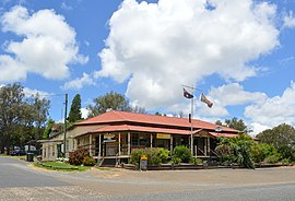
 Waratah Hotel at Mungungo, 2017 | |||||||||||||||
| Coordinates | 24°46′02″S 151°09′50″E / 24.7672°S 151.1638°E | ||||||||||||||
| Population | 84 (2021 census)[1] | ||||||||||||||
| • Density | 0.820/km2 (2.125/sq mi) | ||||||||||||||
| Postcode(s) | 4630 | ||||||||||||||
| Area | 102.4 km2 (39.5 sq mi) | ||||||||||||||
| Time zone | AEST (UTC+10:00) | ||||||||||||||
| Location | |||||||||||||||
| LGA(s) | North Burnett Region | ||||||||||||||
| State electorate(s) | Callide | ||||||||||||||
| Federal division(s) | Flynn | ||||||||||||||
| |||||||||||||||
Mungungo is a rural town and locality in the North Burnett Region, Queensland, Australia.[2][3] In the 2021 census, the locality of Mungungo had a population of 84 people.[1]
Geography
Mungungo is in the Wide Bay-Burnett region, 488 kilometres (303 mi) north west of the state capital, Brisbane.
History
The name Mungungo is believed to mean "darkness" or "night" in an unidentified Aboriginal language. Until 1929, the town was known as Waratah.[3]
Clonmel State School opened on 12 April 1926 and closed in 1967.[4] It was on the eastern side of Monal Road (24°44′26″S 151°10′08″E / 24.74059°S 151.16890°E).[5][6]
The Mungungo Hall (also known as School of Arts) was officially opened with a dance on Saturday 13 July 1929.[7] celebrated its 90th birthday in 2019.[8]
The now-abandoned Gladstone to Monto railway line reached Mungungo in 1930 with two now-abandoned stations in the locality:
- Crana railway station (24°45′39″S 151°11′14″E / 24.7607°S 151.1873°E)[9]
- Mungungo railway station (24°46′02″S 151°09′45″E / 24.7672°S 151.1624°E)[9]
Demographics
In the 2016 census, the locality of Mungungo had a population of 77 people.[10]
In the 2021 census, the locality of Mungungo had a population of 84 people.[1]
Education
There are no schools in Mungungo. The nearest government primary and secondary schools are Monto State School and Monto State High School, both in neighbouring Monto to the south.[6]
Amenities

Mungungo is well known for its pub which is one of the few available eateries in the area.[citation needed]
Mungungo Public Hall is at 14 Harris Street (24°46′05″S 151°09′48″E / 24.7680°S 151.1634°E).[11]
Attractions
The Bicentennial National Trail passes through Mungungo.[12]
References
- ^ a b c Australian Bureau of Statistics (28 June 2022). "Mungungo (SAL)". 2021 Census QuickStats. Retrieved 28 February 2023.
- ^ "Mungungo – town in North Burnett Region (entry 23491)". Queensland Place Names. Queensland Government. Retrieved 14 August 2022.
- ^ a b "Mungungo – locality in North Burnett Region (entry 45400)". Queensland Place Names. Queensland Government. Retrieved 14 August 2022.
- ^ Queensland Family History Society (2010), Queensland schools past and present (Version 1.01 ed.), Queensland Family History Society, ISBN 978-1-921171-26-0
- ^ "Queensland Two Mile series sheet 2m160" (Map). Queensland Government. 1939. Retrieved 26 November 2023.
- ^ a b "Queensland Globe". State of Queensland. Retrieved 26 November 2023.
- ^ "MONTO". Maryborough Chronicle, Wide Bay and Burnett Advertiser. No. 18, 264. Queensland, Australia. 27 July 1929. p. 5. Retrieved 16 November 2022 – via National Library of Australia.
- ^ Treacy, Alex (9 July 2019). "Small hall set to have a big birthday ball". The Courier Mail. Retrieved 20 October 2022.
- ^ a b "Railway stations and sidings - Queensland". Queensland Open Data. Queensland Government. 2 October 2020. Archived from the original on 5 October 2020. Retrieved 5 October 2020.
- ^ Australian Bureau of Statistics (27 June 2017). "Mungungo (SSC)". 2016 Census QuickStats. Retrieved 20 October 2018.
- ^ "Mungungo School of Arts Hall" (Map). Google Maps. Retrieved 16 November 2022.
- ^ "Regional Road Map NORTH BURNETT" (PDF). North Burnett Regional Council (6 ed.). 2018. Retrieved 20 October 2022.
Further reading
- Pat Bowles, ed. (1979), Bancroft and associated schools 1929-1979 : Bukali, Kolanga, Railway construction camp, Bancroft, Cannindah, Clonmel, Ventnor., Bancroft and District Jubilee Committee

