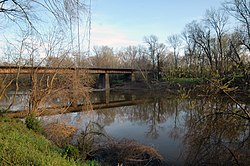
Meherrin River
| Meherrin River Tributary to Chowan River | |
|---|---|
 The Meherrin at Emporia, Virginia | |
 Chowan River Watershed | |
| Location | |
| Country | United States |
| State | Virginia North Carolina |
| County | Hertford (NC) Northampton (NC) Southampton (VA) Greensville (VA) Brunswick (VA) Mecklenburg (VA) Lunenburg (VA) |
| City | Emporia, Virginia Murfreesboro, NC |
| Physical characteristics | |
| Source | confluence of South Meherrin River and North Meherrin River |
| • location | Reekes Mill, Virginia |
| • coordinates | 36°49′11″N 078°16′32″W / 36.81972°N 78.27556°W[1] |
| • elevation | 258 ft (79 m)[2] |
| Mouth | Chowan River |
• location | about 0.5 miles north of Chowan Beach, North Carolina |
• coordinates | 36°25′54″N 076°56′53″W / 36.43167°N 76.94806°W[1] |
• elevation | 0 ft (0 m)[3] |
| Length | 143.37 mi (230.73 km)[4] |
| Basin size | 1,601.05 square miles (4,146.7 km2)[5] |
| Discharge | |
| • location | Chowan River |
| • average | 1,565.82 cu ft/s (44.339 m3/s) at mouth with Chowan River[5] |
| Basin features | |
| Progression | Chowan River → Albemarle Sound[4] |
| River system | Chowan River |
| Tributaries | |
| • left | North Meherrin River, Mason Creek, Crooked Creek, Flat Rock Creek, Stony Creek, Aaron Creek, Shining Creek, Briery Branch, Flat Branch, Saddletree Creek, Totaro Creek, Great Creek, Robinson Creek, Reedy Creek, Greensville Creek, Metcalf Branch, Caney Branch, Big Branch, Buckhorn Swamp, Burnt Reeds Swamp |
| • right | South Meherrin River, Buckhorn Creek, Piney Creek, Mountain Creek, Smith Creek, Taylors Creek, Evans Creek, Genito Creek, Hays Creek, Allen Creek, Coldwater Creek, Big Branch, Brandy Creek, Lightfoot Creek, Millpond Creek, Douglas Run, Falling Run, Fountains Creek, Cypress Creek, Kirbys Creek, Worrell Mill Swamp, Potecasi Creek |
| Bridges | Oral Oaks Road, North Whittles Mill Road, Craig Mill Road, VA 138, Dixie Bridge Road, I-85, US 1, US 58, Robinson Ferry Road, Meherrin Beach Road, VA 46, Iron Bridge Road, Western Mill Road, I-95, Main Street, Hicksford Avenue, Little Texas Road, NC 186, Branches Bridge Road, NC 35, Boones Bridge Road, US 258, |

The Meherrin River is a 143.37 mi (230.73 km) long 6th order tributary to the Chowan River that joins in Hertford County, North Carolina.
A twenty-foot-high dam on the river creates a reservoir in Emporia.[citation needed] For most of its length, the Meherrin is not large enough for commercial traffic. It widens somewhat between Murfreesboro, North Carolina and the Chowan. Prior to the American Civil War, this section of the river was a significant trading route for Northeastern North Carolina.
The river was named after the Meherrin Indians, whose territory was along it.[citation needed]
Variant names
According to the Geographic Names Information System, it has also been known historically as:[1]
- Maherine River
- Maherrin River
- Mehearin River
- Meherin River
- Pochike River
- Wayanock
- Woodford River
Course
The Meherrin River is formed at the confluence of the South Meherrin River and North Meherrin River at Reekes Mill, Virginia, and then flows southeasterly into North Carolina to join the Chowan River about 0.5 miles north of Chowan Beach in Hertford County, North Carolina.[3]
Watershed
The Meherrin River drains 1,601.05 square miles (4,146.7 km2) of area, receives about 46.3 in/year of precipitation, has a wetness index of 495.22, and is about 46% forested.[5]
See also
References
- ^ a b c "GNIS Detail - Meherrin River". geonames.usgs.gov. US Geological Survey. Retrieved 19 May 2021.
- ^ "Get Maps". USGS Topoview. US Geological Survey. Retrieved 19 May 2021.
- ^ a b "Get Maps". USGS Topoview. US Geological Survey. Retrieved 19 May 2021.
- ^ a b "ArcGIS Web Application". epa.maps.arcgis.com. US EPA. Retrieved 19 May 2021.
- ^ a b c "Meherrin River Watershed Report". US EPA Geoviewer. US EPA. Retrieved 19 May 2021.


