Maritime Continent

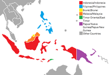
Maritime Continent is the name given primarily by meteorologists and oceanographers to the region of Southeast Asia which comprises, amongst other countries, Indonesia, Philippines and Papua New Guinea. In some usage the maritime continent includes the Malay Peninsula.[1] Located between the Indian and Pacific Oceans, it is situated within a warm ocean region known as the Tropical Warm Pool.
The maritime continent consists of many islands, peninsulas and shallow seas. The region is significant in meteorology because it is considered the most important energy source region in the entire global circulation system owing to a number of coincident factors, the most significant being geographic location and topography, both of which contribute to the development of the Tropical Warm Pool, which is the warmest large area of ocean on Earth.
Coined by Colin Ramage in 1968,[2] the name combines the terms maritime and continent normally used as opposites in the description of climate. Maritime air is humid, and continental air is dry.
In the Southeast Asia region, land masses and bodies of water are, roughly speaking, evenly distributed. Moreover, the land masses are characterized by high mountains, and the seas are among the warmest on the Earth. This produces a widespread area of diurnal thunderstorms which pump huge quantities of moisture and heat high up into the atmosphere. These in turn feed the upper-level winds which circle the globe.
References
- ^ http://www.bom.gov.au/climate/about/tropics/maritime-continent.shtml [bare URL]
- ^ Ramage, C.S. (June 1968). "Role of a tropical "maritime continent" in the atmospheric circulation". Monthly Weather Review. 96 (6): 365–370. Bibcode:1968MWRv...96..365R. doi:10.1175/1520-0493(1968)096<0365:ROATMC>2.0.CO;2.
External links
