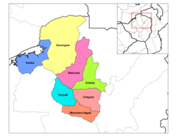
Makonde District
Makonde District | |
|---|---|
 Makonde District in Mashonaland West Province | |
| Country | Zimbabwe |
| Province | Mashonaland West |
| Area | |
• Total | 8,564 km2 (3,307 sq mi) |
| Population (2022 census) | |
• Total | 209,960 |
| • Density | 25/km2 (63/sq mi) |
Makonde District is a district in Zimbabwe.
Location
The district is located in Mashonaland West Province, in north central Zimbabwe. Its main town, Chinhoyi, with an estimated population of 61,739 people in 2004,[1] is located about 125 kilometres (78 mi), by road, northwest of Harare, the capital of Zimbabwe and the largest city in that country.[2]
Overview
Makonde District is a farming district. Crops grown here include cotton, maize and tobacco. Cattle are also raised in the district for dairy products and beef on a commercial basis. Mining of copper also takes place.
Chinhoyi, the district headquarters is a college town, hosting two major universities, namely: Chinhoyi University of Technology (CUT) and Zimbabwe Open University (ZOU). There are three major high schools; Chinhoyi High School, Nemakonde High School and Lomagundi College. In addition the district is home to numerous primary schools.
Population
In 2010, the district population was estimated at 167,436 people.[3] The 2022 census estimated a population of 209,960.[4]
Urban centers in the district include Chinhoyi, the provincial and district headquarters, Alaska approximately 15 kilometres (9.3 mi) directly west of Chinhoyi,[5] and Lion's Den, which lies about 25 kilometres (16 mi), northwest of Chinhoyi, on the road to Chirundu.
See also
References
- ^ "What is the population of chinhoyi, zimbabwe? - Wolfram|Alpha". Wolframalpha.com. Retrieved 24 April 2015.
- ^ "Distance between Harare (Harare) and Chinhoyi () (Zimbabwe)". Distancecalculator.globefeed.com. Retrieved 24 April 2015.
- ^ "What is the population of makonde district, zimbabwe? - Wolfram|Alpha". Wolframalpha.com. 18 August 2002. Retrieved 24 April 2015.
- ^ "Zimbabwe: Administrative Division (Provinces and Districts) - Population Statistics, Charts and Map". www.citypopulation.de. Retrieved 17 February 2024.
- ^ "Distance between Alaska () and Chinhoyi () (Zimbabwe)". Distancecalculator.globefeed.com. Retrieved 24 April 2015.
