Makalondi
Makalondi | |
|---|---|
Commune | |
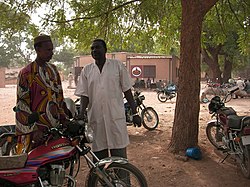
 Health Center in Makalondi | |
 | |
| Area | |
• Total | 1,226 km2 (473 sq mi) |
| Population | |
• Total | 73,271 |
Makalondi is a rural commune in the Torodi department of Niger. As of 2012, it had a population of 73,271.[1]
Geography
Makalondi is located in the Sahel. It borders Burkina Faso in the south and west.
Flora and fauna
On the higher plains of Makalondi, for which tiger bush is typical as a vegetation form, grow winged seed plants, acacias, monkey bread trees, doum palms and caritat trees. Khaya senegalensis and Tamarind thrive in the lowlands.[2] The average rainfall level between 1961 and 1990 was about 600 mm (23 in).[3] The Makalondi District is recognized as an Important Bird Area. The major birds include the Long-tailed glossy starling and the Savile's bustard. The birds were studied mainly by Pierre Souvairan, who lived in the area for 30 years between 1968 and 1998.[3] Until the 1970s, large mammals, including Loxodonta africana, Panthera leo and Syncerus caffer were common, particularly in the western part of the area. Most disappeared following extensive clearance of land for agriculture during the 1980s.[3]
History
Makalondi was separated from the territory of the rural community of Torodi on 18 August 2009 as a separate commune.[4] The reasons for the separation of Torodi included the high population density in this area and in particular the position of Makalondi as an important border town.[5] Since 2011, Makalondi has not belonged to the Say department, but to the newly founded department of Torodi.
Population
Makalondi had 73,271 inhabitants as of the 2012 census, which lived in 8975 households.[6]
Culture
In Makalondi there are two Roman Catholic parishes belonging to the Archdiocese of Niamey: the parish of St. Francis in the main town, founded in 1967, and the parish of St. Spirit in the village of Bomanga (Bomoanga), founded in 1994. Its members are mainly members of the Gurma people ethnic group.[7]
References
- ^ "MAKALONDI Commune in Niger". 25 August 2018. Retrieved 29 July 2020.
- ^ Montagne, P (1997). Les marchés ruraux de bois-énergie au Niger : outils de développement rural local (in French). p. 196. ISBN 2-7420-0193-X.
- ^ a b c "Makalondi district". Birdlife Date Zone. Retrieved 29 July 2020.
- ^ "Le Sahel" (PDF) (in French). Archived from the original (PDF) on 7 October 2009. Retrieved 29 July 2020.
- ^ "Le Sahel newspaper August 19 2009" (PDF). Archived (PDF) from the original on 23 August 2009. Retrieved 30 July 2020.
- ^ "Répertoire National des Localités (ReNaLoc)" (in French). Archived from the original on 4 March 2016. Retrieved 30 July 2020.
- ^ "Catholiques du Niger" (in French). Retrieved 30 July 2020.
