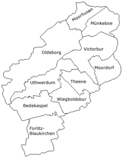
Münkeboe
Münkeboe | |
|---|---|
 | |
| Coordinates: 53°30′59″N 7°22′36″E / 53.51629°N 7.37676°E | |
| Country | Germany |
| State | Lower Saxony |
| District | Aurich |
| Municipality | Südbrookmerland |
| Elevation | 4 m (13 ft) |
| Population | |
| • Metro | 1,713[1] |
| Time zone | UTC+01:00 (CET) |
| • Summer (DST) | UTC+02:00 (CEST) |
| Dialling codes | 04942 |
| Vehicle registration | 26624 |
Münkeboe is an East Frisian village in Lower Saxony, Germany. It is an Ortsteil of the municipality of Südbrookmerland, in the district of Aurich. It is located southwest of the Ewiges Meer and approximately 8 kilometers northwest of Aurich.
Münkeboe was an independent municipality until it was incorporated into the municipality of Südbrookmerland on 1 July 1972.[2]
The village has a museum, Dörpmuseum Münkeboe, exhibiting old handicrafts and tools used by the rural population. The museum includes a functioning windmill, a wheelwright's shop, a blacksmith's shop, a carpenter's shop, a pottery, a bakery, a classroom, and a grocery store.[3]
Etymology
Münkeboe is a moor settlement established in 1764 and first mentioned in the Engerhafe church register in 1771. The place was first recorded in 1787 as Münkeboo. The current spelling has been documented since 1825. The name of the settlement means "monk's hut", which is based on the fact that, according to reports, the first colonists found remains of walls in the ground here, which could indicate a property of a former monastery.[4]
Gallery
- Dörpmuseum Münkeboe
- Interior of the Church of the Good Shepherd
References
- ^ "Über die Gemeinde" [About the municipality]. Südbrookmerland (in German). Retrieved 22 October 2024.
- ^ "Die Geschichte des Südbrookmerlandes" [The history of Südbrookmerland]. Südbrookmerland (in German). Retrieved 22 October 2024.
- ^ "Übersicht". Dörpmuseum Münkeboe (in German). Retrieved 22 October 2024.
- ^ "Münkeboe" (PDF). Ostfriesische Landschaft (in German). Retrieved 22 October 2024.


