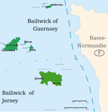
List of lighthouses in the Channel Islands

This is a list of lighthouses in the Channel Islands. The archipelago lies to the west of the Cotentin Peninsula in the English Channel. There are lighthouses on all of the four main islands: Alderney, Guernsey, Jersey and Sark.[1][2][3]
Lighthouses in the Bailiwick of Guernsey
| Name | Image | Location & coordinates |
Year built | Tower height (in metres) |
Focal height ( in metres) |
Admiralty number |
|---|---|---|---|---|---|---|
| Alderney Lighthouse |  | Alderney 49°43′45″N 2°9′51″W | 1912 | 32 | 37 | A1536 |
| Bréhon Tower |  | Guernsey 49°28′17″N 2°29′18″W | 1856 | 7 | 19[4] | A1559 |
| Crocq Pierhead lighthouse | Saint Sampson 49°28′58″N 2°30′59″W | 6 | 11 | A1554 | ||
| Castle Breakwater Lighthouse |  | Saint Peter Port 49°27′18″N 2°31′27″W | 1850s | 12 | 14 | A1560 |
| Casquets lighthouses |  | Alderney 49°43′19″N 2°22′37″W | 1724[5] | 23[5] | 37[6][5] | A1532 |
| Les Hanois Lighthouse |  | Torteval 49°26′1″N 2°42′1″W | 1862[7] | 36 | 33[6] | A1580 |
| St Martins Point Lighthouse |  | Jerbourg Point 49°25′18″N 2°31′42″W | 5 | 15 | A1574 | |
| Platte Fougère lighthouse |  | Saint Sampson 49°30′51″N 2°29′7″W | 1910 | 25 | 25 | A1548 |
| Platte lighthouse | Little Roussel 49°29′15″N 2°29′52″W | 6 | 9 | A1550 | ||
| Roustel Beacon | Little Roussel 49°29′14″N 2°28′49″W | 1970 | 8 | 10 | A1552 | |
| Sark Lighthouse |  | Point Robert 49°26′11″N 2°20′44″W | 1913 | 17 | 65[6] | A1544 |
| St Sampsons South Pier, Range Rear |  | Saint Sampson 49°28′57″N 2°31′4″W | 1874 | 12 | 13 | A1558.1 |
| Tautenay Lighthouse | Herm 49°30′6″N 2°26′49″W | 8 | 7 | A1548.5 | ||
| Victoria Marina Lighthouse | Saint Peter Port Harbour 49°27′19″N 2°32′2″W | 7 | 10 | A1569 | ||
| White Rock Pier Lighthouse |  | Saint Peter Port Harbour 49°27′23″N 2°31′35″W | 1908 | 10 | 11 | A1562 |
Lighthouses in the Bailiwick of Jersey
| Name | Image | Location & coordinates |
Year built | Tower height (in metres) |
Focal height (in metres) |
Admiralty number |
|---|---|---|---|---|---|---|
| La Corbière Lighthouse |  | La Corbière 49°10′47″N 2°15′0″W | 1874 | 19 | 36[6] | A1620 |
| St. Catherine's Breakwater Lighthouse |  | Saint Martin 49°13′20″N 2°0′38″W | 9 | 18 | A1586 | |
| Demie de Pas Lighthouse |  | Saint Helier 49°9′1″N 2°6′9″W | 1904 | 13 | 11 | A1598 |
| Gorey Pier Lighthouse |  | Gorey 49°11′48″N 2°1′20″W | 1966 | 9 | 8 | A1588 |
| Greve d'Azette Lighthouse |  | Saint Helier 49°10′7″N 2°5′4″W | 1896 | 19 | 23 | A1594 |
| La Tour de Vinde |  | Saint Brelade 49°9′55″N 2°10′5″W | 1915 | 10 | 18 | A1616 |
| Sorel Point Lighthouse |  | Saint John 49°15′36″N 2°9′32″W | 1938 | 3 | 49.7 | A1584 |
| Mount Ube lighthouse |  | Saint Helier 49°10′18″N 2°3′36″W | 1896 | 14 | 46 | A1594.1 |
See also
References
- ^ Rowlett, Russ. "Lighthouses of Jersey". The Lighthouse Directory. University of North Carolina at Chapel Hill. Retrieved 10 January 2015.
- ^ Rowlett, Russ. "Lighthouses of Guernsey". The Lighthouse Directory. University of North Carolina at Chapel Hill. Retrieved 10 January 2015.
- ^ List of Lights, Pub. 114: British Isles, English Channel and North Sea (PDF). List of Lights. United States National Geospatial-Intelligence Agency. 2014. p. 124.
- ^ NGA List of Lights, Radio Aids and Fog Signals, National Geospatial-Intelligence Agency, Wikidata Q13872896
- ^ a b c https://www.trinityhouse.co.uk/lighthouses-and-lightvessels/casquets-lighthouse
- ^ a b c d Reeds PBO Small Craft Almanac 2014. ISBN 978-1-4081-9330-3. OL 32692860M. Wikidata Q25198336.
- ^ Tom Nancollas (2018). Seashaken Houses. ISBN 978-1-84614-938-2. OL 28716637M. Wikidata Q80678896.
External links
- Rowlett, Russ. "The Lighthouse Directory". University of North Carolina at Chapel Hill.
