List of populated places in Antigua and Barbuda
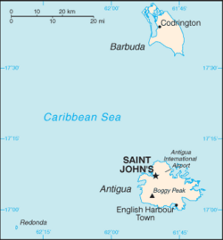
This is a list of settlements in Antigua and Barbuda, sorted by alphabetical order.


List
Antigua
Saint John
- Aberdeen - 17°04′12″N 61°48′35″W / 17.06994°N 61.80977°W
- Adelin
- Barrymore
- Branns Hamlet - 17°06′13″N 61°50′10″W / 17.10366°N 61.83612°W
- Belmont - 17°05′59″N 61°49′34″W / 17.09964°N 61.82612°W
- Bellevue Heights - 17°05′32″N 61°49′23″W / 17.0922°N 61.82302°W
- Belvedere - 17°04′04″N 61°50′19″W / 17.06772°N 61.83867°W
- Bendals - 17°04′05″N 61°50′10″W / 17.06807°N 61.83604°W
- Black Rock - 17°10′09″N 61°49′39″W / 17.16912°N 61.82741°W
- Blue Waters
- Boon House - 17°10′00″N 61°50′00″W / 17.16667°N 61.83333°W
- Buckleys - 17°04′20″N 61°48′48″W / 17.07221°N 61.81337°W
- Cedar Grove - 17°09′44″N 61°49′04″W / 17.16225°N 61.8178°W
- Cedar Valley - 17°08′00″N 61°48′00″W / 17.13333°N 61.8°W
- Clare Hall - 17°07′00″N 61°49′00″W / 17.11667°N 61.81667°W
- Clarkes Hill
- Cooks Hill
- Cooks New Extension
- Crosbies - 17°09′56″N 61°49′25″W / 17.16569°N 61.82367°W
- Deanery
- Emanuel - 17°04′20″N 61°50′14″W / 17.07217°N 61.83731°W
- Five Islands - 17°07′10″N 61°53′02″W / 17.11944°N 61.88388°W
- Friars Hill - 17°08′47″N 61°50′03″W / 17.14634°N 61.83406°W
- Gambles
- Gamble's Terrace
- Golden Grove - 17°05′21″N 61°50′49″W / 17.08903°N 61.84685°W
- Gray Hill
- Grays Farm
- Green Bay - 17°06′53″N 61°50′56″W / 17.11468°N 61.84892°W
- Green Castle
- Hamiltons - 17°03′00″N 61°50′00″W / 17.05°N 61.83333°W
- Hattons - 17°07′00″N 61°51′11″W / 17.11654°N 61.85302°W
- Herberts - 17°05′38″N 61°48′51″W / 17.094°N 61.81403°W
- Hodges Bay
- Jacks Hill, Antigua and Barbuda
- Marble Hill
- Martin Hill - 17°04′22″N 61°49′01″W / 17.07291°N 61.81704°W
- McKinnon’s
- Montclear
- Nut Grove
- Obeez
- Old Battery
- Olivers - 17°04′38″N 61°48′56″W / 17.07713°N 61.81551°W
- Ottos
- Paradise View - 17°08′58″N 61°50′30″W / 17.14953°N 61.84161°W
- Piggott's Ville
- Potters Buff - 17°06′13″N 61°48′47″W / 17.10366°N 61.81297°W
- Potters Village - 17°06′48″N 61°49′11″W / 17.11337°N 61.81962°W
- Prison Farm
- Radio Range
- Renfrew - 17°05′25″N 61°48′39″W / 17.09023°N 61.81071°W
- Side Hill - 17°07′05″N 61°51′45″W / 17.11817°N 61.86245°W
- Skerrits
- St. Claire
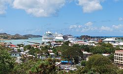
- St. John's
- St. Luke - 17°04′44″N 61°50′04″W / 17.07877°N 61.83437°W
- Soldier - 17°10′07″N 61°50′10″W / 17.16859°N 61.83619°W
- Sutherlands - 17°06′45″N 61°52′48″W / 17.11241°N 61.88007°W
- Sutherlands Development - 17°07′22″N 61°49′46″W / 17.12268°N 61.8295°W
- Tomlinson - 17°06′48″N 61°48′29″W / 17.11327°N 61.80808°W
- Union Road
- Upper Gamble's
- Villa
- Weatherhills - 17°09′55″N 61°50′07″W / 17.16514°N 61.83534°W
- Woods - 17°08′07″N 61°49′33″W / 17.13526°N 61.82585°W
- Yeptons - 17°07′30″N 61°52′20″W / 17.12493°N 61.87235°W
- Yorks
Saint Mary
Saint Paul
Saint Philip
Saint Peter
- All Saints (Saint Peter portion)
- Big Duers
- Cedar Hill
- Cochranes
- Cocoa Hall (Mercers Creek Division)[1]
- Crabs Mill
- Diamonds
- Freemans
- Gilberts (Mercers Creek Division)[1]
- Jonas (All Saints)
- Mount Joy
- Pares
- Parham
- Parham Hill
- Parrys
- Sandersons
- The Garden
- Twenty Hill
- Vernons
- Yeamans
Saint George
Barbuda
- Codrington
- Broady
- Guava Farm
- Indigo North
- Indigo South
- Jeffrey Wood
- Meadow East
- Meadow West
- Middle Section
- Mulatto North
- Mulatto South
- Park
- Spring View
- Barbuda-North
- Barbuda-East
- Barbuda-South
- White Ponds East
- White Ponds West
Largest settlements
- Saint John's 22,634
- All Saints 3,412
- Liberta 2,239
- Potter's Village 2,067
- Bolans 1,785
- Swetes 1,573
- Seaview Farm 1,486
- Piggotts 1,363
- Codrington 1,325
- Parham 1,276
Populated places in 1856
The following is a complete list of settlements, specifically towns and villages during 1856:[2]
| Settlement Name | Total Population | Parish |
|---|---|---|
| City of Saint John | 8,515 | Saint John |
| All Saints | 283 | |
| Saint James | 389 | |
| Hamiltons | 202 | |
| Aberdeen | 46 | |
| Wilcox | 108 | |
| Laws | 22 | |
| Williams' Farm | 46 | |
| Bendals | 44 | |
| Bush Town | 33 | |
| Ferris' Farm | 9 | |
| Fort James | 25 | |
| Alleynes | 279 | |
| Hainings | 102 | |
| Potters | 179 | |
| Grays | 381 | |
| Tomlinsons | 172 | |
| Cooks | 36 | |
| Galley Bay | 367 | |
| Gray's Hill | 395 | |
| Side Hill & Green Bay | 866 | |
| Goat Hill | 10 | |
| Gracefield | 7 | |
| Olivers | 12 | |
| Crabb Hill | 133 | Saint Mary |
| Johnson's Point | 162 | |
| Dalzel's | 6 | |
| Urlin's | 104 | |
| Saint Mary's Glebe | 10 | |
| Bailey Hill | 19 | |
| Old Road Town | 96 | |
| Grace Bay | 50 | |
| Sea Valley | 44 | |
| Fairfield | 114 | |
| Green Hill (1) | 73 | |
| Kingston | 83 | |
| Fisher's | 16 | |
| River | 104 | |
| Nanton's | 85 | |
| Cedar Grove | 44 | |
| John Hughes | 128 | |
| Bishop's | 116 | |
| Green Hill (2) | 219 | |
| Jenning's | 117 | |
| Thompson's | 189 | |
| Darby's | 125 | |
| McGregor's | 20 | |
| Dunning's | 45 | |
| Jenning's (top) | 42 | |
| Gillards | 60 | |
| Bolans | 508 | |
| Dunning's (bottom) | 22 | |
| Roses | 38 | |
| Tottenham | 25 | |
| The Rectory | 16 | Saint Philip |
| Farrs Hill Village | 913 | |
| Seatons | 791 | |
| Newfield | 403 | |
| Willoughby Bay | 87 | |
| Wilkies | 249 | |
| Mayers | 40 | |
| Salters | 47 | |
| McKay Lands | 5 | |
| Sandy Ground | 3 | |
| Brooks Lands | 11 | |
| Grays Hill | 13 | |
| Winthropes Village | 309 | Saint George |
| Barnes Hill | 194 | |
| Saint Marks | 365 | |
| Osborns Farm | 213 | |
| Sea View Farm | 1,119 | |
| English Harbour | 986 | Saint Paul |
| Falmouth | 211 | |
| The Ridge | 62 | |
| Ffryes | 122 | |
| Victoria | 85 | |
| Bethesda | 299 | |
| Grace Hill | 151 | |
| Liberta | 788 | |
| Buckshorns | 19 | |
| Edwards | 63 | |
| Sweets | 572 | |
| Jenny Bush | 171 | |
| Spring Hill | 116 | |
| Bailey Hill | 31 | |
| Ding-a-ding-nook | 18 | |
| Parham | 500 | Saint Peter |
| Glebe | 123 | |
| Freemans | 537 | |
| Pares | 139 | |
| Osborns | 101 | |
| Parham Lodge | 194 | |
| Parham Hill | 83 | |
| Vernons | 82 |
Data for small estates, typically the size of tiny hamlets, were also collected. No estate had a larger population than a village. This list is incomplete and currently only has data for Saint John.
| Estate Name | Population | Parish |
|---|---|---|
| Thibou's | 47 | Saint John |
| Wood | 59 | |
| Drews Hill | 47 | |
| Skerrets and Clare Hall | 125 | |
| Dunbars | 67 | |
| Ottos | 94 | |
| Langfords | 191 | |
| Crosbies | 62 | |
| Hodges Bay | 67 | |
| Briggins | 90 | |
| Thibou Jarvis | 239 | |
| Mount Pleasant | ||
| Wetherills | ||
| Cedar Valley | ||
| Will Blizards | ||
| Tomlinsons | ||
| Cedar Grove | ||
| Marble Hill | ||
| Sir Geo. Thomas, Upper | ||
| Sir Geo. Thomas, Lower | ||
| Hawkes Bill | ||
| Brecknock | ||
| Turnbull's | ||
| Belvidere | ||
| Buckley's | ||
| Saint Clare | ||
| Mount View | ||
| Cookes | ||
| Friars Hill | ||
| Galley Bay | ||
| Potters | ||
| Villa | ||
| Belmont | ||
| Herberts | ||
| George Byams | ||
| Rose Hill | ||
| Hill House | ||
| Bendals | ||
| McKinnons | ||
| Harts and Royals | ||
| Cassada Garden | ||
| Adneys | ||
| Gambles | ||
| Union | ||
| Yapton | ||
| Denfield | ||
| Bath Lodge | ||
| Belle Vue | ||
| Renfrew | ||
| Body Ponds |
See more
References
- ^ a b Martin., Adams, Henry (1891), [Island of Antigua]., [publisher not identified], OCLC 13213586, retrieved 2023-02-24
{{citation}}: CS1 maint: multiple names: authors list (link) - ^ Commons, Great Britain Parliament House of (1858). Accounts and Papers of the House of Commons. Ordered to be printed.
