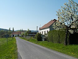
Kuřimany
Kuřimany | |
|---|---|
 Northern entrance to Kuřimany | |
| Coordinates: 49°12′14″N 13°58′5″E / 49.20389°N 13.96806°E | |
| Country | |
| Region | South Bohemian |
| District | Strakonice |
| First mentioned | 1327 |
| Area | |
• Total | 3.11 km2 (1.20 sq mi) |
| Elevation | 476 m (1,562 ft) |
| Population (2024-01-01)[1] | |
• Total | 46 |
| • Density | 15/km2 (38/sq mi) |
| Time zone | UTC+1 (CET) |
| • Summer (DST) | UTC+2 (CEST) |
| Postal code | 386 01 |
| Website | www |
Kuřimany is a municipality and village in Strakonice District in the South Bohemian Region of the Czech Republic. It has about 50 inhabitants.
Etymology
The name Kuřimany meant "the village of people who lived in Kouřim / who came from Kouřim".[2]
Geography
Kuřimany is located about 7 kilometres (4 mi) southeast of Strakonice and 44 km (27 mi) northwest of České Budějovice. It lies in the Bohemian Forest Foothills. The highest point is at 565 m (1,854 ft) above sea level. The brook Třešovický potok flows through the municipality.
History
The first written mention of Kuřimany is from 1327.[3]
Demographics
|
|
| ||||||||||||||||||||||||||||||||||||||||||||||||||||||
| Source: Censuses[4][5] | ||||||||||||||||||||||||||||||||||||||||||||||||||||||||
Transport
There are no railways or major roads passing through the municipality.
Sights

The main landmark of Kuřimany is the Chapel of Saint John of Nepomuk with a Baroque gable and bell tower.[3]
References
- ^ "Population of Municipalities – 1 January 2024". Czech Statistical Office. 2024-05-17.
- ^ Profous, Antonín (1949). Místní jména v Čechách II: CH–L (in Czech). pp. 452–453.
- ^ a b "O obci" (in Czech). Obec Kuřimany. Retrieved 2023-02-13.
- ^ "Historický lexikon obcí České republiky 1869–2011" (in Czech). Czech Statistical Office. 2015-12-21.
- ^ "Population Census 2021: Population by sex". Public Database. Czech Statistical Office. 2021-03-27.


