Klobouky u Brna
Klobouky u Brna | |
|---|---|
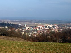
 General view of the town | |
| Coordinates: 48°59′42″N 16°51′34″E / 48.99500°N 16.85944°E | |
| Country | |
| Region | South Moravian |
| District | Břeclav |
| First mentioned | 1210 |
| Government | |
| • Mayor | Pavel Volek |
| Area | |
• Total | 31.27 km2 (12.07 sq mi) |
| Elevation | 228 m (748 ft) |
| Population (2024-01-01)[1] | |
• Total | 2,501 |
| • Density | 80/km2 (210/sq mi) |
| Time zone | UTC+1 (CET) |
| • Summer (DST) | UTC+2 (CEST) |
| Postal code | 691 72 |
| Website | www |
Klobouky u Brna is a town in Břeclav District in the South Moravian Region of the Czech Republic. It has about 2,500 inhabitants.
Administrative parts
The village of Bohumilice is an administrative part of Klobouky u Brna.
Etymology
The Czech word klobouky literally means 'hats'. The name was probably derived from the shape of the surrounding hills.[2]
Geography
Klobouky u Brna is located about 25 kilometres (16 mi) north of Břeclav and 28 km (17 mi) southeast of Brno. Almost the entire municipal territory lies in the Ždánice Forest, only a small part in the east extends into the Kyjov Hills. The highest point is the Nedánov hill at 368 m (1,207 ft) above sea level.
History
The first written mention of both Klobouky and Bohumilice is from 1210, when Lev of Klobouky donated the villages to the Premonstratensian monastery in Zábrdovice (today part of Brno), which he founded. In 1298, Klobouky was promoted to a market town by King Wenceslaus II. The monastery owned the Klobouky estate until its abolishment in 1784.[3][4]
Klobouky was located on an important route between Moravia and Kingdom of Hungary, from which it profited in times of peace, but suffered from the passage of troops and looting in times of war. The settlement was badly damaged during the Bocskai uprising and during the Thirty Years' War.[2]
Klobouky obtained the town status in 1964.[2] On 7 October 1992, the town was renamed Klobouky u Brna.[5]
Demographics
|
|
| ||||||||||||||||||||||||||||||||||||||||||||||||||||||
| Source: Censuses[6][7] | ||||||||||||||||||||||||||||||||||||||||||||||||||||||||
Transport
There are no major roads passing through the town. The railway that starts in the eastern part of the municipal territory is unused.
Sights

Among the landmarks of the town centre are a castle and two churches. The Church of Saint Lawrence was built in the Baroque style in 1655.[8] The Evangelical church was built in the Historicist style and dates from the second half of the 19th century.[9]
The Klobouky u Brna Castle is the most important urban component of the town. It originally served as a residence of the Zábrdovice monastery.[10] Today it houses the town museum.[2]
The main symbol of Klobouky u Brna is a two-story wooden windmill, located on a hill near the town. It was moved here from Pacetluky in 1825. After it was destroyed by fire during World War II, the mill was reconstructed in 1985.[2][11]
The Chapel of Saint Barbara was built in 1669. It is a distinctive feature located on a hill above the town.[3]
References
- ^ "Population of Municipalities – 1 January 2024". Czech Statistical Office. 2024-05-17.
- ^ a b c d e "Klobouky u Brna" (in Czech). CzechTourism. Retrieved 2023-11-20.
- ^ a b "Kaple sv. Barbory" (in Czech). Město Klobouky u Brna. Retrieved 2023-11-20.
- ^ "Místní část Bohumilice" (in Czech). Město Klobouky u Brna. Retrieved 2023-11-20.
- ^ "Historický lexikon obcí České republiky – 1869–2005" (in Czech). Czech Statistical Office. 2004-12-31. p. 229. Retrieved 2023-11-20.
- ^ "Historický lexikon obcí České republiky 1869–2011" (in Czech). Czech Statistical Office. 2015-12-21.
- ^ "Population Census 2021: Population by sex". Public Database. Czech Statistical Office. 2021-03-27.
- ^ "Kostel sv. Vavřince" (in Czech). National Heritage Institute. Retrieved 2023-11-20.
- ^ "Evangelický kostel" (in Czech). National Heritage Institute. Retrieved 2023-11-20.
- ^ "Zámek" (in Czech). National Heritage Institute. Retrieved 2023-11-20.
- ^ "Větrný mlýn" (in Czech). National Heritage Institute. Retrieved 2023-11-20.


